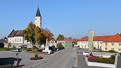
Langau

Last updated
Langau
Langau - Ortszentrum.JPG
AUT Langau COA.png
Coat of arms
Austria adm location map.svg
Red pog.svg
Langau
Location within Austria
Coordinates: 48°49′N15°42′E / 48.817°N 15.700°E / 48.817; 15.700 Coordinates: 48°49′N15°42′E / 48.817°N 15.700°E / 48.817; 15.700
Country Austria
State Lower Austria
District Horn
Government
   Mayor Franz Linsbauer
Area
[1]
  Total22.22 km2 (8.58 sq mi)
Elevation
450 m (1,480 ft)
Population
 (2018-01-01) [2]
  Total673
  Density30/km2 (78/sq mi)
Time zone UTC+1 (CET)
  Summer (DST) UTC+2 (CEST)
Postal code
2091
Area code 02912
Website www.langau.at

Langau is a town in the district of Horn in Lower Austria, Austria.

Population

Historical population
YearPop.±%
1923989    
19511,294+30.8%
19611,313+1.5%
19711,042−20.6%
1981892−14.4%
1991763−14.5%
2001686−10.1%
2011989+44.2%

Related Research Articles

Alberschwende Place in Vorarlberg, Austria

Alberschwende is a municipality in the district of Bregenz in the Austrian state of Vorarlberg.

Wolfurt Place in Vorarlberg, Austria

Wolfurt is a municipality in the western Austrian state of Vorarlberg.

Schwarzach, Vorarlberg Place in Vorarlberg, Austria

Schwarzach is a municipality in the Austrian state of Vorarlberg.

Nenzing Place in Vorarlberg, Austria

Nenzing is a market town in the district of Bludenz in the Austrian state of Vorarlberg.

Warth, Vorarlberg Place in Vorarlberg, Austria

Warth is a municipality in the district of Bregenz in the Austrian state of Vorarlberg.

Lorüns Place in Vorarlberg, Austria

Lorüns is a municipality in the district of Bludenz in the Austrian state of Vorarlberg.

Sankt Gallenkirch Place in Vorarlberg, Austria

Sankt Gallenkirch is a municipality in the district of Bludenz in the Austrian state of Vorarlberg.

Silbertal Place in Vorarlberg, Austria

Silbertal is a municipality in the district of Bludenz in the Austrian state of Vorarlberg.

Buch, Austria Place in Vorarlberg, Austria

Buch is a municipality in the district of Bregenz in the Austrian state of Vorarlberg.

Fußach Place in Vorarlberg, Austria

Fußach is a municipality in the district of Bregenz in the Austrian state of Vorarlberg.

Gaißau Place in Vorarlberg, Austria

Gaißau is a municipality in the district of Bregenz in the Austrian state of Vorarlberg.

Höchst, Austria Place in Vorarlberg, Austria

Höchst is a municipality in the district of Bregenz in the Austrian state of Vorarlberg.

Hörbranz Place in Vorarlberg, Austria

Hörbranz is a municipality in the district of Bregenz in the Austrian state of Vorarlberg.

Göfis Place in Vorarlberg, Austria

Göfis is a municipality in the district of Feldkirch in the Austrian state of Vorarlberg.

Klaus, Vorarlberg Place in Vorarlberg, Austria

Klaus is a municipality in the district of Feldkirch in the Austrian state of Vorarlberg.

Röthis Place in Vorarlberg, Austria

Röthis is a municipality in the district of Feldkirch in the Austrian state of Vorarlberg.

Sulz, Vorarlberg Place in Vorarlberg, Austria

Sulz is a municipality in the district of Feldkirch in the Austrian state of Vorarlberg.

Altschwendt Place in Upper Austria, Austria

Altschwendt is a municipality in the district of Schärding in the Austrian state of Upper Austria.

Schwanenstadt Place in Upper Austria, Austria

Schwanenstadt is a town in the district of Vöcklabruck in the Austrian state of Upper Austria.

Bad Waltersdorf Place in Styria, Austria

Bad Waltersdorf is a municipality in the district of Hartberg-Fürstenfeld in Styria, Austria.

References

  1. "Dauersiedlungsraum der Gemeinden Politischen Bezirke und Bundesländer - Gebietsstand 1.1.2018". Statistics Austria. Retrieved 10 March 2019.
  2. "Einwohnerzahl 1.1.2018 nach Gemeinden mit Status, Gebietsstand 1.1.2018". Statistics Austria. Retrieved 9 March 2019.
Parish church Langau - Kirche.JPG
Parish church