
The West Midlands County is a metropolitan county and combined authority area in western-central England with a 2018 estimated population of 2,916,458, making it the second most populous county in England after Greater London. It came into existence as a metropolitan county in 1974 after the passage of the Local Government Act 1972, formed from parts of Staffordshire, Worcestershire and Warwickshire. The county itself is a NUTS 2 region within the wider NUTS 1 region of the same name. The county consists of seven metropolitan boroughs: the City of Birmingham, the City of Coventry and the City of Wolverhampton, as well as the boroughs of Dudley, Sandwell, Solihull and Walsall.

The Black Country is an area of the West Midlands, England, west of Birmingham and commonly refers to a region of more than one million people covering most of the four Metropolitan Boroughs of Dudley, Sandwell, and Walsall. During the Industrial Revolution, it became one of the most industrialised parts of the UK with coal mines, coking, iron foundries, glass factories, brickworks and steel mills producing a high level of air pollution.
West Bromwich is a market town in the borough of Sandwell, West Midlands, England. Historically part of Staffordshire, it is 6.4 miles (10.3 km) northwest of Birmingham. West Bromwich is part of the area known as the Black Country, in terms of geography, culture, and dialect. West Bromwich had a population of almost 78,000 in 2018.

Dudley is a large industrialised market town and administrative centre in the county of West Midlands, England, 6 miles (9.7 km) south-east of Wolverhampton and 10.5 miles (16.9 km) north-west of Birmingham. Historically in Worcestershire, the town is the administrative centre of the Metropolitan Borough of Dudley and in 2011 had a population of 79,379. The Metropolitan Borough, which includes the towns of Stourbridge and Halesowen, had a population of 312,900. Dudley is sometimes called the capital of the Black Country.
Tipton is an industrial town in the West Midlands in England with a population of around 38,777 at the 2011 UK Census.

Smethwick is an industrial town in Sandwell, West Midlands, historically in Staffordshire. It is 4 miles west of Birmingham city centre and borders West Bromwich and Oldbury to the north and west. Formerly a Staffordshire county borough, Smethwick is situated near the edge of Sandwell metropolitan borough and borders the Birmingham districts of Handsworth, Winson Green, Harborne, Edgbaston and Quinton to the south and east, as well as the Black Country towns of West Bromwich and Oldbury in the north and west.

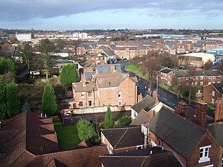
Sandwell is a metropolitan borough of the West Midlands county in England. The borough is named after the Sandwell Priory, and spans a densely populated part of the West Midlands conurbation. According to Sandwell Metropolitan Borough Council, the borough comprises the six amalgamated towns of Oldbury, Rowley Regis, Smethwick, Tipton, Wednesbury, and West Bromwich, although these places consist of numerous smaller settlements and localities. Though West Bromwich is the largest town in the borough and its designated Strategic Town Centre, Sandwell Council House is situated in Oldbury.
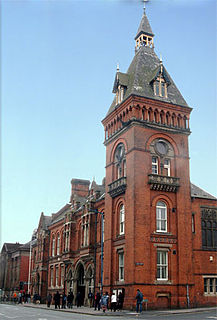
Oldbury is an industrialized market town and administrative centre in Sandwell, West Midlands, England. It is a part of the Black Country, and the administrative centre of the borough of Sandwell.

The West Midlands is one of nine official regions of England at the first level of NUTS for statistical purposes. It covers the western half of the area traditionally known as the Midlands. It contains Birmingham and the larger West Midlands conurbation, which is the third most populous in the United Kingdom. The City of Coventry is also located within the West Midlands county, but is separated from the conurbation to the west by several miles of green belt. The region also contains 6 shire counties which stretch from the Welsh Border to the East Midlands.

The Black Country Living Museum is an open-air museum of rebuilt historic buildings in Dudley, West Midlands, England. It is located in the centre of the Black Country, 10 miles west of Birmingham. The museum occupies 105,000 square metres of former industrial land partly reclaimed from a former railway goods yard, disused lime kilns, canal arm and former coal pits.

Bournbrook is an industrial and residential district in southwest Birmingham, England, in both the Selly Oak Council Ward and the Parliamentary District of Selly Oak. Prior to what is commonly termed the Greater Birmingham Act, which came into effect on 9 November 1911, the Bourn Brook watercourse was the North Eastern boundary of Worcestershire, and the area was locally governed by the King’s Norton and Northfield Urban District Council.

Sandwell and Dudley railway station is on the Birmingham Loop of the West Coast Main Line, on the outskirts of Oldbury town centre on Bromford Lane, England. The name of the station is somewhat misleading; the station is actually located between West Bromwich and Oldbury, and not near Dudley. The nearest station to the town of Dudley is actually Dudley Port.
Wordsley is a village of Stourbridge in the West Midlands, England. It is part of the Metropolitan Borough of Dudley and falls into the Stourbridge (DY8) postcode and address area, being just north of the River Stour. Wordsley is part of the Dudley South Parliamentary constituency and backs onto open countryside with an extensive array of luxury property.
The BCN Main Line, or Birmingham Canal Navigations Main Line describes the evolving route of the Birmingham Canal between Birmingham and Wolverhampton in England.

Wolverhampton is a city, administrative centre and metropolitan borough in the West Midlands, England. At the 2011 census, it had a population of 249,470. The demonym for people from the city is 'Wulfrunian.'

The Titford Canal is a narrow (7 foot) canal, a short branch of the Birmingham Canal Navigations (BCN) in Oldbury, West Midlands, England.
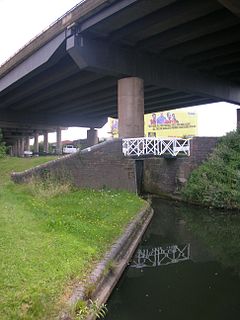
Spon Lane Junction is the original junction of the Wednesbury Canal and the Birmingham Canal, near Oldbury in the West Midlands, England.

Between the late 11th century and 1844, the English county of Shropshire had a large exclave within the present-day Black Country and surrounding area. This territory was gained from neighbouring Worcestershire, and the exclave's border corresponded with the medieval Manor of Hala. Shropshire (Detached) contained the townships of Halesowen, Oldbury, Warley Salop, Ridgacre, Hunnington, Romsley and Langley. The exceptions were Cradley, Lutley and Warley Wigorn, which were exclaves or enclaves still aligned with the original county. Bounded entirely by Staffordshire and Worcestershire, Hala was part of Brimstree hundred, and totally detached from the rest of Shropshire. Bridgnorth, the nearest town within the main body of Shropshire, is 16.8 miles (27.03 km) away from Halesowen, whilst the county town of Shrewsbury is 34.6 miles (55.62 km) away.

The Fox and Grapes was an historic, heritage-designated public house in the Digbeth area of Birmingham, England. After some time derelict, and a major fire, it was demolished in 2018.


