Langue de Barbarie

Last updated
Birds flock on the beach at the Langue de Barbarie National Park, 2006. Senegal 2006.jpg
Birds flock on the beach at the Langue de Barbarie National Park, 2006.
Ruins in the park LangueBarbarie.jpg
Ruins in the park

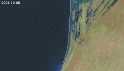
The Langue de Barbarie (French for "Barbary spit of land", named after the Barbary Coast) is a thin, sandy peninsula, adjacent to the Atlantic Ocean, located in western Senegal, in the neighbourhood of the city of Saint-Louis. [1] The peninsula separates the ocean from the final section of the Senegal River.

Contents

National park

Designations
Official nameParc National de la Langue de Barbarie
Designated7 April 2021
Reference no.2467 [2]

The Langue de Barbarie National Park (French : Parc National de la Langue de Barbarie) is located at the southern edge of the peninsula. Covering an area of 2,000 hectares (4,900 acres), it is home to an abundant variety of bird species and three species of turtle, including the critically endangered hawksbill sea turtle. [3] [4] The park was named a Ramsar site in 2021. [2]

2003 breach and environmental disaster

Animation of the widening of the breach. Langue de Barbarie breach animation.gif
Animation of the widening of the breach.

A 4 metres (13 ft) breach was cut in the peninsula near the city of Saint-Louis on 3 October 2003 to help counter possible flooding. However, the breach quickly widened to 800 m (2,600 ft) and separated the southern end of the peninsula permanently from the main country, effectively transforming it into an island. [5] As of December 2013 the sea has claimed over 3 km (1.9 mi) of land and has caused the loss of villages and tourist resorts in addition to changes in the flora and fauna of the peninsula. [6] [7] [8] By January 2020, the breach had widened to 6 km. [9]

Related Research Articles

<span class="mw-page-title-main">16th arrondissement of Paris</span> French municipal arrondissement in Paris, France

The 16th arrondissement of Paris is one of the 20 arrondissements of the capital city of France. In spoken French, this arrondissement is referred to as seizième.

<span class="mw-page-title-main">Barbary Coast</span> Coastal region of North Africa inhabited by Berber people

The Barbary Coast was the name given to the coastal regions of North Africa or Maghreb, specifically the Ottoman borderlands consisting of the regencies in Algiers and Tripoli, as well as the Beylik of Tunis and the Sultanate of Morocco from the 16th to 19th centuries. The term originates from the exonym of the Berbers.

<span class="mw-page-title-main">Saint-Louis, Senegal</span> Town in Saint-Louis Region, Senegal

Saint Louis or Saint-Louis, is the capital of Senegal's Saint-Louis Region. Located in the northwest of Senegal, near the mouth of the Senegal River, and 320 kilometres (200 mi) north of Senegal's capital city Dakar, it has a population officially estimated at 258,592 in 2021. Saint-Louis was the capital of the French colony of Senegal from 1673 until 1902 and French West Africa from 1895 until 1902, when the capital was moved to Dakar. From 1920 to 1957, it also served as the capital of the neighboring colony of Mauritania.

<span class="mw-page-title-main">Louis Faidherbe</span> French general and colonial administrator (1818–1889)

Louis Léon César Faidherbe was a French general and colonial administrator. He created the Senegalese Tirailleurs when he was governor of Senegal.

<span class="mw-page-title-main">W National Park</span> National park in West Africa

The W National Park or W Regional Park is a major national park in West Africa around a meander in the River Niger shaped like the letter W. The park includes areas of the three countries Niger, Benin and Burkina Faso, and is governed by the three governments. Until 2008, the implementation of a regional management was supported by the EU-funded project ECOPAS. The three national parks operate under the name W Transborder Park.. The section of W National Park lying in Benin, measuring over 8,000 km2 (3,100 sq mi), came under the full management of African Parks in June 2020. In Benin, W National Park is contiguous with Pendjari National Park which is also under the management of African Parks.

<span class="mw-page-title-main">Parc de la Tête d'or</span> Urban park in Lyon

The Parc de la Tête d'or is a large urban park in Lyon, France, with an area of approximately 117 hectares. Located in the northern part of the 6th arrondissement, it features the Jardin botanique de Lyon, as well as a lake on which boating takes place during the summer months. Due to the relatively small number of other parks in Lyon, it receives a huge number of visitors over summer; it is a frequent destination for joggers and cyclists.

<span class="mw-page-title-main">Tourism in Senegal</span>

Tourism in Senegal is a vital part of the West African nation's economy.

<span class="mw-page-title-main">Faidherbe Bridge</span> Road bridge in Senegal

Faidherbe Bridge is a road bridge over the Senegal River which links the island of the city of Saint-Louis in Senegal to the African mainland. The metal bridge is 507.35 m (1,664.5 ft) long and 10.5 m (34 ft) wide, weighing 1,500 t. It has eight spans, of which the longest five are 78.26 m (256.8 ft).

Ruvubu National Park is a national park in Burundi covering 508 km2 (196 sq mi) that was established in 1980. Its borders fall within the provinces of Karuzi, Muyinga, Cankuzo and Ruyigi. The park touches neighboring Tanzania to the south, the valley of the Ruvubu River whose landscape dominates this area.

<span class="mw-page-title-main">Ifrane National Park</span> National park in the Moyen Atlas mountains, Morocco

Ifrane National Park is a national park located in the Middle Atlas mountain range, in Morocco. Its territory extends over the Western part of the Middle Atlas mountains and areas within the provinces of Ifrane and Boulmane. It was established in 2004 and covers an area of 125,000 hectares. Much of the park is forested with Atlas cedar. Ifrane National Park is one of the few remaining habitats for the Barbary macaque, Macaca sylvanus; this primate prehistorically had a much broader range in North Africa, but currently survives as an endangered species in narrowly restricted and fragmented habitats.

<span class="mw-page-title-main">Réunion National Park</span> French national park in Réunion

Réunion National Park is a National Park of France located on the island of Réunion, an overseas department in the western Indian Ocean. Established on 5 March 2007, the park protects the endemic ecosystems of Les Hauts, Réunion's mountainous interior, and covers around 42% of the island. Notable endemic species include the Réunion cuckooshrike and the Reunion Island day gecko.

Basse Casamance National Park, located near Oussouye in Ziguinchor, is one of six national parks in Senegal. It is currently closed.

<span class="mw-page-title-main">Mont-Saint-Bruno National Park</span>

Mont-Saint-Bruno Provincial Park is a small national park of Quebec located near the municipality of Saint-Bruno-de-Montarville, 15 kilometres (9.3 mi) to the east of Montréal on the south shore of the Saint Lawrence River. The park, with an area of 8.84 square kilometres (3.41 sq mi), notably includes Mont Saint-Bruno, one of the Monteregian Hills which peaks at 218 metres (715 ft). The mountain is shared with the Ski Mont Saint-Bruno ski resort, a quarry and a small Canadian Forces training camp. Despite its relatively small size, the mountain is known for its rich fauna and flora. Situated at the heart of the old signory of Montarville, its many lakes have permitted the construction and exploitation of many water mills, contributing to the region's economical success. A building from one of those mills, the "Vieux Moulin", still stands to this day and is used as a rest area for skiers and hikers in different seasons.

<span class="mw-page-title-main">Landes de Gascogne Regional Natural Park</span> Regional natural park of France

Landes de Gascogne Regional Natural Park is a protected area of pine forest, wetland and oceanic coastline located in the Landes de Gascogne natural region of Nouvelle-Aquitaine in southwestern France.

<span class="mw-page-title-main">Djoudj National Bird Sanctuary</span>

The Djoudj National Bird Sanctuary lies on the southeast bank of the Senegal River in Senegal, in northern Biffeche, north east of St-Louis.

Haut Atlas Oriental National Park is located in Morocco. It covers 49,000 hectares in and near the eastern High Atlas mountains. Parts of the park have been designated as a protected Ramsar site since 2005.

<span class="mw-page-title-main">Khenifiss National Park</span> National park in Morocco

Khenifiss National Park is a national park in the southwest of Morocco, located near Akhfenir on the Atlantic coast in the region of Laâyoune-Sakia El Hamra. It was established in 2006. The area of the park is 1,850 square kilometres (710 sq mi). The national park was created to protect desert, wetlands, and coastal dunes.

<span class="mw-page-title-main">Point of Sangomar</span> Sand spit located on the Atlantic Ocean at the mouth of the Saloum Delta

The Point of Sangomar is a sand spit located on the Atlantic Ocean at the mouth of the Saloum Delta, which marks the end of the Petite Côte west of Senegal.

<span class="mw-page-title-main">Sept Îles Archipelago Regional Park</span> Proposed protected area in Quebec, Canada

The Sept Îles Archipelago Regional Park is a proposed protected area in the Côte-Nord region of Quebec, Canada. The islands are important to migratory sea birds, and are also of interest to tourists. The management plan was prepared in 2008.

<span class="mw-page-title-main">Mauritania–Senegal border</span> International border

The Mauritania–Senegal border is 742 km in length and runs from the Atlantic Ocean in the west along the Senegal River to the tripoint with Mali in the east.

References

  1. Deith, Jane (2007-05-05). "Senegal fights hunger to save birds". BBC News online. BBC . Retrieved 2007-08-08.
  2. 1 2 "Parc National de la Langue de Barbarie". Ramsar Sites Information Service. Retrieved 2 March 2022.
  3. "Parcs et réserves" (in French). Environment Ministry, Senegalese Government. 13 October 2005. Archived from the original on 2009-01-30. Retrieved 8 January 2014.
  4. "Parc National de la Langue de Barbarie". World Bird Database. BirdLife International . Retrieved 8 August 2007.
  5. "Le parc national de la Langue de Barbarie" (in French). Senegalaisement.com. 29 May 2009. Retrieved 20 October 2011.
  6. Grisot, Maureen (11 December 2013). "Près de Saint-Louis du Sénégal, la mer engloutit les villages". Le Monde (in French). Retrieved 5 January 2014.
  7. Triplet, Patrick; Benmergui, Maurice; Schricke, Vincent (2010). "Évolution de quelques espèces d'oiseaux d'eau dans le delta du fleuve Sénégal – Période 1989-2010" (PDF). Faune Sauvage (in French). 289: 6–13. Retrieved 8 January 2014.
  8. Durand, Paul; Anselme, Brice; Thomas, Yves-François (27 April 2010). "L'impact de l'ouverture de la brèche dans la langue de Barbarie à Saint-Louis du Sénégal en 2003: un changement de nature de l'aléa inondation ?". Cybergeo: European Journal of Geography (in French). doi: 10.4000/cybergeo.23017 . Retrieved 8 January 2014.
  9. Pronczuk, Monika (2020-01-28). "How the 'Venice of Africa' is losing its battle against the rising ocean". The Guardian. ISSN   0261-3077 . Retrieved 2020-01-29.

Coordinates: 15°55′N16°30′W / 15.917°N 16.500°W / 15.917; -16.500