
Skaun is a municipality in Trøndelag county, Norway. It is part of the Orkdalen region. The administrative centre of the municipality is the village of Børsa. Other villages include Buvika, Eggkleiva, Melby, Skaun, and Viggja.

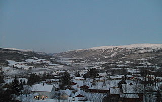
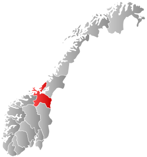
Klæbu is a municipality in Trøndelag county, Norway. It is located in the southern part of the Trondheim Region, about 20 kilometres (12 mi) south of the city of Trondheim. The administrative center is the village of Klæbu. The other major village in Klæbu municipality is Tanem.

Malvik is a municipality in Trøndelag county, Norway. It is part of the Trondheim Region. The administrative center of the municipality is the village of Hommelvik. Other villages in Malvik include Muruvika, Smiskaret, Sneisen, Vikhammer, and Hundhammeren.

Tydal is a municipality in Trøndelag county, Norway. The administrative centre of the municipality is the village of Ås. Other villages include Østby, Gressli, Aunet, and Stugudalen. There is a school and a kindergarten in Tydal.
Meråker is a municipality in Trøndelag county, Norway. It is part of the Stjørdalen region. The administrative centre of the municipality is the village of Midtbygda which is about 20 kilometres (12 mi) west of Storlien in Sweden and 46 kilometres (29 mi) east of the town of Stjørdalshalsen in neighboring Stjørdal municipality. Other villages in Meråker include Gudåa, Kopperå, and Stordalen.

Stjørdal or Skierde is a municipality in Trøndelag county, Norway. It is part of the Stjørdalen region. The administrative centre of the municipality is the town of Stjørdal, also called Stjørdalshalsen. Some of the villages in the municipality include Elvran, Flornes, Hegra, Hell, Kvithammer, Prestmoen, Skatval, Skjelstadmarka, Sona, and Værnes.

Svorkmo is a village in the municipality of Orkdal in Trøndelag county, Norway. It is situated in the Orkdalen valley along the river Orkla about 60 kilometres (37 mi) west-southwest of the city of Trondheim. Svorkmo is located about 3.5 kilometres (2.2 mi) south of the village of Vormstad and about 11 kilometres (6.8 mi) south of the urban area of Orkanger-Fannrem-Råbygda. The lake Svorksjøen lies about 7 kilometres (4.3 mi) to the east of the village.

Orkanger is a town and the administrative centre of Orkdal municipality in Trøndelag county, Norway. The town is also a former municipality which existed from 1920 until 1963. The town sits at the end of the Orkdalsfjorden, and arm of the Trondheimsfjord. Orkanger is the commercial centre of the municipality of Orkdal and it is the site of the Orkanger Church. It was established as a "town" in 2014.

Skatval is a village in the municipality of Stjørdal in Trøndelag county, Norway. It is located on the Skatval peninsula about 8 kilometres (5.0 mi) northwest of the town of Stjørdalshalsen. The inhabitants are called as Skatvalsbygg. Skatval Church is located in the village.

Vanvikan is a village in the municipality of Indre Fosen in Trøndelag county, Norway. It is located along the Trondheimsfjord in the southeastern part of the municipality. The village of Seter lies about 10 kilometres (6.2 mi) northeast of Vanvikan and the lake Storvatnet lies about 4 kilometres (2.5 mi) north of the village. One of the schools in the municipality, Vanvikan Skole is located in the village of Vanvikan. Stranda Church is also located in the village.

Storås is a village in the municipality of Meldal in Trøndelag county, Norway. It is located along the Orkla River, about 8 kilometres (5.0 mi) northwest of the village of Meldal. For most Norwegians, Storås is best known for hosting the annual festival called Storåsfestivalen since 2004. The nearest major city is Trondheim.
Ringvål is a village in the municipality of Trondheim in Trøndelag county, Norway. The village is located in the borough of Heimdal, at the mouth of the Gaula River between the urban areas of Heimdal and Spongdal.

Korsvegen is a village in the municipality of Melhus in Trøndelag county, Norway. It is located about 40 kilometres (25 mi) south of the city of Trondheim, just west of the lake Benna. The village was the administrative centre of the old municipality of Hølonda which existed from 1865 until 1964.

Soknedal is a village in Midtre Gauldal municipality in Trøndelag county, Norway. The village is located along the river Sokna which flows north and later joins the river Gaula. The Dovrebanen railway line and the European route E06 highway both run through the village, heading to the city of Trondheim which is about 60 kilometres (37 mi) to the north. The village of Støren lies about 12 kilometres (7.5 mi) to the north and the village of Berkåk lies about 16 kilometres (9.9 mi) to the south.
Trolla is a village in the municipality of Trondheim in Trøndelag county, Norway. It is located in the Midtbyen borough, along the Trondheimsfjord on the north coast of the Bymarka area. It is about 10 kilometres (6.2 mi) northeast of the village of Langørjan and about 4 kilometres (2.5 mi) northwest of the Ila neighborhood in the city of Trondheim.
Spongdal is a village in the municipality of Trondheim in Trøndelag county, Norway. It is the largest village in the Byneset area in Heimdal borough. It is located between the villages of Langørjan and Ringvål. The Byneset Church lies about 2.5 kilometres (1.6 mi) west of the village of Spongdal.
Byneset is a former municipality in Sør-Trøndelag county, Norway. The 78.5-square-kilometre (30.3 sq mi) municipality existed from 1838 until its dissolution in 1964. The municipality of Byneset encompassed the western part of what is now Trondheim municipality in Trøndelag county. Byneset was located along an arm of the Trondheimsfjord and it was separated from the city of Trondheim by the Bymarka recreation area. The local Byneset Church is one of the oldest stone churches in Norway. The largest village in Byneset was Spongdal which was the administrative centre of the municipality. Other villages included Byneset and Langørjan.
Bratsberg is a village in Trondheim municipality in Trøndelag county, Norway. The village is located in the borough of Lerkendal, between the village of Tanem and the lake Jonsvatnet. The 0.26-square-kilometre (64-acre) village has a population (2018) of 379 and a population density of 1,458 inhabitants per square kilometre (3,780/sq mi).
Hundhammeren is a village in the municipality of Malvik in Trøndelag county, Norway. The village is located along an arm of the Trondheimsfjord, about 1.5 kilometres (0.93 mi) west of the village of Vikhammer and about 4 kilometres (2.5 mi) east of the village of Ranheim.
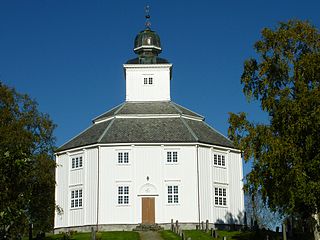
Klæbu is the administrative centre of Klæbu municipality in Trøndelag county, Norway. The village is located on the eastern shore of the river Nidelva, about 2 kilometres (1.2 mi) east of the village of Tanem and about 15 kilometres (9.3 mi) south of the city of Trondheim. The village sits at the junction of Norwegian county roads 805 and 921. The historic Klæbu Church is located in the village.


