
St Austell is a town in Cornwall, England, United Kingdom, 10 miles (16 km) south of Bodmin and 30 miles (48 km) west of the border with Devon.

The Bodmin and Wenford Railway is a 6 miles 12 chains (9.9 km) heritage railway at Bodmin in Cornwall, England. Its headquarters are at Bodmin General railway station and it connects with the national rail network at Bodmin Parkway.

The Bodmin and Wadebridge Railway was a railway line opened in 1834 in Cornwall, England, United Kingdom. It linked the quays at Wadebridge with the town of Bodmin and also to quarries at Wenfordbridge. Its intended traffic was minerals to the port at Wadebridge and sea sand, used to improve agricultural land, inwards. Passengers were also carried on part of the line.

London Apprentice is a village in south Cornwall, England, UK, on the banks of St Austell River in the Pentewan Valley approximately two miles (3 km) south of St Austell.
The Wrexham and Minera Railway or Wrexham and Minera Branch was a railway line in North Wales between the city of Wrexham, the village of Brymbo where it served the Brymbo Steelworks, and the lead mines and limeworks at Minera. A further branch ran from Brymbo to Coed Talon, where it connected with lines to Mold. The system was constructed in several stages between 1844 and 1872, while the various lines making up the system closed in 1952, 1972 and 1982.
The Lostwithiel and Fowey Railway opened in 1869 as a broad gauge railway linking the port of Fowey in Cornwall with the Cornish Main Line at Lostwithiel. Its main traffic was china clay. The company ran into financial difficulties and closed in 1880, but the line was purchased by the Cornwall Minerals Railway and reopened in 1895.
The Newquay and Cornwall Junction Railway was a 7 ft broad gauge railway intended to link the Cornwall Railway with the horse-worked Newquay Railway. It opened a short section to Nanpean in 1869, the remainder being built by the Cornwall Minerals Railway who took over the company in 1874. Its main traffic has always been china clay.

The Clay Trails are a series of bicycle trails located in mid Cornwall, England, United Kingdom. The trails pass through the St Austell moorland which for over two centuries has been extensively quarried for china clay, hence the name.
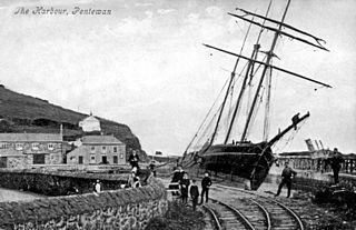
The Pentewan Railway was a 2 ft 6 in narrow gauge railway in Cornwall, England. It was built as a horse-drawn tramway carrying china clay from St Austell to a new harbour at Pentewan, and was opened in 1829. In 1874 the line was strengthened for locomotive working. It finally succumbed to more efficient operation at other ports and closed in 1918.
The South Wales Mineral Railway was a railway built to serve collieries in the upper Afan Valley, and bring their output to a dock at Briton Ferry, in South Wales. It opened in stages, in 1861 and 1863. It was built on the broad gauge and had steep gradients, including a rope worked incline near Briton Ferry.
The Pontypool, Caerleon & Newport Railway was promoted independently to relieve congestion on the heavily worked Eastern Valley Line of the Monmouthshire Railway and Canal Company. The Great Western Railway put up half the capital, making it in effect a GWR subsidiary. It opened in 1874, and most long-distance passenger and goods traffic, especially the heavy mineral traffic, transferred to it. It amalgamated with the GWR in 1876.
The Liskeard and Looe Railway was a railway originally built between Moorswater, in the valley west of Liskeard, and Looe, in Cornwall, England, UK, and later extended to Liskeard station on the Cornish Main Line railway. The first section was opened in 1860 and was owned by the Liskeard and Looe Union Canal Company, whose canal had earlier been built to convey sea sand and lime up the valley of the East Looe River, for the purpose of improving agricultural land.

The Cornwall Minerals Railway owned and operated a network of 45 miles (72 km) of standard gauge railway lines in central Cornwall, England, United Kingdom. It started by taking over an obsolescent horse-operated tramway in 1862, and it improved and extended it, connecting Newquay and Par Harbours, and Fowey. Having expended considerable capital, it was hurt by a collapse in mineral extraction due to a slump in prices. Despite its title, it operated a passenger service between Newquay and Fowey.
The Treffry Tramways were a group of mineral tramways in Cornwall in the United Kingdom, constructed by Joseph Treffry (1782-1850), a local land owner and entrepreneur. They were constructed to give transport facilities to several mines and pits producing non-ferrous metal, granite and china clay in the area between the Luxulyan Valley and Newquay, and were horse-operated, with the use of water and steam power on inclines, and at first operated in conjunction with the Par Canal and Par Docks, also constructed by Treffry. One of the routes crossed the Luxulyan Valley on a large viaduct, the largest in Cornwall when it was built.
There are eight disused railway stations between Wadebridge and Bodmin North on the former Bodmin and Wadebridge Railway in Cornwall, in the United Kingdom, with ten other closed sidings on the branches to Ruthern Bridge and Wenfordbridge. The section from Boscarne Junction to Bodmin General is currently part of the Bodmin and Wenford Steam Railway; the line from Wadebridge to Wenfordbridge is now part of the Camel Trail, and the line to Ruthern Bridge can be followed for much of its length as it runs parallel to a public road.

Pentewan is a coastal village and former port in south Cornwall, England, United Kingdom. It is situated at grid reference SX 019 472 3 miles (4.8 km) south of St Austell at the mouth of the St Austell River.
The Truro and Newquay Railway was a Great Western Railway line in Cornwall, England, designed to keep the rival London and South Western Railway (LSWR) out of the west of the county. The line was completed in 1905 and closed in 1963.

The St Austell River properly known as the River Vinnick, but historically called The White River, is a 12 kilometres (7.5 mi) long river located in south Cornwall, England, United Kingdom. 50.337°N 4.793°W. The river has also been known as the "red river" due to tin streaming and mining activity upstream.

The Wheal Martyn China Clay Museum is a museum of china clay mining, at Carthew, on the B3274 road about 2 miles (3.2 km) north of St Austell in Cornwall, England. A Victorian clay works has been preserved, and there is an exhibition building.
The Cornish China Clay Branches are a number of railway branch lines that serve facilities that produce or process China Clay. The area of Cornwall north of St Austell stretching from Bodmin Moor towards Truro is known for the extraction and processing of commercial volumes of China Clay, and with the expansion of the railways in the 19th century a number of lines were constructed to access various mines and clay-dries. Some branches have closed over the years, but several still operated into the 21st century although much of the China Clay traffic has transferred to road transport. In 2020 rail traffic remained in the shape of regular trains running between Parkandillack and the wharves at Carne Point where the large volumes required to be loaded onto ships for export would make road transport uneconomic.
