Signy Island is a small subantarctic island in the South Orkney Islands of Antarctica. It was named by the Norwegian whaler Petter Sørlle (1884–1933) after his wife, Signy Therese.

Little Traverse Bay is a small bay, 170 feet deep, off Lake Michigan in the northern area of the Lower Peninsula of Michigan. The cities of Harbor Springs and Petoskey are located on this bay.

Mandalay State Beach is a protected beach in the city of Oxnard, California, United States. Managed by the California Department of Parks and Recreation, the park preserves an area of undeveloped sand dunes and wetlands that was once common along the 16.5-mile-long (26.6 km) coastline of the Oxnard Plain.

Larchmont Yacht Club is a private, members-only yacht club situated on Larchmont Harbor in the Village of Larchmont, in Westchester County, New York.

Clear Lake is the name of a natural spring fed body of water located in Cerro Gordo County, Iowa near Clear Lake, Iowa. It is approximately 3,684 acres (15 km2) in size. It is a popular fishing destination, with walleye, yellow bass and channel catfish. People from Des Moines and Minneapolis–Saint Paul have had homes on the shores of the lake since the 1870s. The average depth is 10 feet (3 m) and the maximum depth is 30 feet (9 m), in the dredged area of the west end. The lake has 13.6 mi (22 km) of shoreline. As of 2004, the lake has seen major efforts undergone to restore its natural clarity, including filtration systems, dredging, and education of local farmers to reduce toxic pesticides from entering the lake. Clear Lake has been named the "Best Iowa Lake Town" by The Des Moines Register and "A Top Vacation Spot" by Midwest Living magazine.

The Bayview Mackinac Boat Race is run by the Bayview Yacht Club of Detroit, Michigan. It is one of the longest fresh-water races in the world with over two hundred boats entering the race each year.

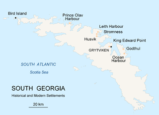
Prince Olav Harbour is small harbour in the south west portion of Cook Bay, entered between Point Abrahamsen and Sheep Point, along the north coast of South Georgia.

Point Judith Pond is a shallow, four-mile (6 km)-long salt body of water lying behind the barrier beaches and sand dunes that form Point Judith Harbor, which lies immediately west of Point Judith in Narragansett, Rhode Island at the southwestern tip of Narragansett Bay. Located about 14 miles (23 km) southwest of Newport Harbor, Point Judith Pond forms a partial border between the communities of Narragansett and South Kingstown, and is connected to Point Judith Harbor by a narrow waterway that cuts through the beaches and sandy shoreline. This waterway is used by a large fishing fleet and local and transient recreational craft. The harbor handles a large amount of passenger traffic, primarily during the summer. Year-round ferry service is available between Point Judith and Block Island.

Sears Rock is a small sub-surface rock about 0.7 miles (1.1 km) west of Rodeo Beach in the Pacific Ocean off Marin County, California. It is the highest point of the larger Centissima Reef, a sub-surface navigation hazard east of the Bonita Channel, although some reports refer to the two as separate features.
Norwalk Harbor is a recreational and commercial harbor and seaport at the estuary of the Norwalk River where it flows into Long Island Sound in Norwalk, Connecticut, United States.

Portage Lake is a natural lake, located in Onekama Township in Manistee County, Michigan, United States. The village of Onekama, Michigan is situated at the northeastern end of the lake.

Big Bay de Noc is a bay in the Upper Peninsula of the U.S. state of Michigan. The bay, which opens into Lake Michigan's Green Bay, is enclosed by Delta County. The small Delta County settlements of Garden and Nahma are harbors on the shore of the bay.

Pea Island is a small island in Long Island Sound and a part of the city of New Rochelle in Westchester County, New York. It features a rocky, grass-covered terrain, with exposed rocks at low tide. The island lies approximately 1 mile from the New Rochelle shore, adjacent to Davids' and Columbia islands, and just west of the New York City border.

Horseshoe Harbor is a bay located on the north shore of Long Island Sound, in the village of Larchmont in Westchester County, New York. This small cove lies just westward of Larchmont Harbor and is used as a launch anchorage for small recreational boats. The deeper water in the entrance favors the eastern side, and the northwest side of the cove is bare at low tide. A rock, bare at low water and marked by a private spindle with can, lies 60 yards off the south side of the point on the west side at the entrance.

New Rochelle Harbor is the name of a harbor located along Long Island Sound in the city of New Rochelle in Westchester County, New York. The Davenport Neck peninsula off the mainland divides New Rochelle's waterfront into two bays; the westerly referred to as New Rochelle Harbor and the easterly as Echo Bay.

Echo Bay is an embayment located off Long Island Sound in the city of New Rochelle in Westchester County, New York. It is an anchorage for small craft and is generally fully occupied during the summer. The depths at the anchorage range from 4 to 15 feet, and launches can anchor in the shallow cove on the northeast side of the harbor, entering between Harrison Islands and the rocky, grassy islet off the northwest side of Echo Island. Vessels frequently anchor between the entrance of Echo Bay and Hicks Ledge, in depths of 20 to 24 feet. On the northwest side of Echo Bay a dredged channel 100 feet wide and 15 feet deep, marked by buoys, leads to the New Rochelle Municipal Marina at Beaufort Point.

Beechmont is an upscale residential community located in the northern end of New Rochelle in Westchester County, New York. Its boundaries are the town of Mamaroneck on the east, by Rochelle Heights on the south, by Huguenot Park on the west and by Forest Heights and Bayberry on the north. Beechmont is within the larger Wykagyl sub-section of New Rochelle, served by the 10804 zip-code. The United States Board on Geographic Names recognizes Beechmont as the official common name for the neighborhood, which it defines as a populated place existing within the incorporated City of New Rochelle.

Premium Point is a guard-gated private community in the city of New Rochelle in Westchester County, New York, United States. The area consists of a series small islands connected by bridges to a peninsular fronting on Long Island Sound and backing on Premium Mill Pond and Echo Bay. Much of the shore line of Premium Point is high and rocky, both on the Sound and on the Bay. Premium Mill Pond is located between the Premium Point peninsula and the mainland. It is fed by the Premium River and is separated from Echo Bay by the former Premium Mill dam.

Sheldrake Lake is a man-made body of water located in the north-eastern section of New Rochelle in Westchester County, New York. It has a surface area of 25 acres and formerly served as the water supply for neighboring Larchmont village. The lake is the result of Larchmont Water Company Dam #2 on the Sheldrake River. The dam, constructed in 1935, is masonry with a height of 31 feet (9.4 m) and a length of 1,000 feet (300 m). The dam has a maximum discharge is 987 cubic feet (27.9 m3) per second and drains an area of 2.66 square miles (6.9 km2).

Ikatan Peninsula is the southeastern extremity of Unimak Island in the U.S. state of Alaska.


