Larne Town (District Electoral Area)

Last updated
Larne Town DEA (1993-2014) within Larne Larne 1993 Larne Town highlight.svg
Larne Town DEA (1993-2014) within Larne

Larne Town was one of the three district electoral areas in Larne, Northern Ireland which existed from 1985 to 2014. The district elected five members to Larne Borough Council, and formed part of the East Antrim constituencies for the Northern Ireland Assembly and UK Parliament.

Contents

It was created for the 1985 local elections, replacing most of Larne Area C which had existed since 1973, and contained the wards of Blackcave, Central, Gardenmore, Harbour and Town Parks. It was abolished for the 2014 local elections and most of the area was transferred to the Coast Road DEA, with some also moving to the Larne Lough DEA.

Councillors

ElectionCouncillor
(Party)
Councillor
(Party)
Councillor
(Party)
Councillor
(Party)
Councillor
(Party)
2011 Roy Craig
(Independent)
Michael Lynch
(Alliance)
Martin Wilson
(SDLP)
Drew Niblock
(DUP)
Jack McKee
(TUV)/
(DUP)
2005 Lindsay Mason
(Independent)
Mark Dunn
(UUP)
2001 Brian Dunn
(UUP)
1997 John Nixon
(Independent)
Rosalie Armstrong
(UUP)
1993 Patricia Kay
(Alliance)
Robert Robinson
(UUP)
1989 Pat Buckley
(Independent)
1985 Liam Kelly
(Alliance)
Leonard Sluman
(DUP)

2011 Election

2005: 2 x Independent, 1 x DUP, 1 x SDLP, 1 x UUP

2011: 1 x DUP, 1 x TUV, 1 x Alliance, 1 x SDLP, 1 x Independent

2005-2011 Change: TUV and Alliance gain from UUP and Independent

Larne Town - 5 seats [1]
PartyCandidateFPv%Count
12345678
TUV Jack McKee *13.56%393399 413 413 441 493  
Independent Roy Craig*13.00%377399 409 416 442 461 560 
Alliance Michael Lynch11.80%342356 359 381 397 404 444 481.81
DUP Drew Niblock12.11%351354 364 365 392 422 448 471.37
SDLP Martin Wilson*11.18%324331 332 432 434 439 452 456.94
DUP Angela Smyth11.00%319326 329 330 337 359 383 392.88
Independent Mark Dunn*6.07%176184 194 195 219 236   
PUP Bill Adamson5.04%146149 166 166 174    
UUP Darin Ferguson5.04%146149 163 164     
Sinn Féin Sean Waide5.28%153154 155      
BNP Robert Bell3.21%9393       
Independent Andrew Swan2.73%79       
Electorate: 6,459  Valid: 2,899 (44.88%)  Spoilt: 28  Quota: 484  Turnout: 2,927 (45.32%)  

    2005 Election

    2001: 2 x Independent, 1 x DUP, 1 x SDLP, 1 x UUP

    2005: 2 x Independent, 1 x DUP, 1 x SDLP, 1 x UUP

    2001-2005 Change: No change

    Larne Town - 5 seats [2]
    PartyCandidateFPv%Count
    1234567891011
    DUP Jack McKee *27.02%939          
    SDLP Martin Wilson*14.71%511512.52 515.9 521.9 524.28 526.28 603.28    
    Independent Roy Craig*12.52%435448.3 450.3 458.3 473.44 485.2 492.2 517.24 571.62 668.62 
    Independent Lindsay Mason *7.02%244253.12 261.12 267.12 277.12 279.88 299.88 313.02 357.02 502.3 550.3
    UUP Mark Dunn8.83%307327.52 329.52 334.52 343.9 423.42 431.42 463.18 494.94 525.32 549.32
    DUP Sharon McKeen3.28%114393.3 395.3 400.3 404.68 413.96 414.96 469.8 477.18 495.46 501.46
    Independent John Anderson7.08%246251.32 262.32 270.32 275.32 278.08 282.08 285.08 324.08   
    Alliance Elena Aceves-Cully5.04%175176.52 185.52 187.52 191.52 193.52 197.52 199.52    
    PUP Bill Adamson3.77%131142.78 143.78 146.78 147.78 150.54 152.54     
    Independent Robert Shaw3.51%122122 126 126 128 129      
    UUP Maxi Burns2.91%101107.46 107.46 109.6 116.36       
    Independent Thomas Robinson 1.64%5761.18 62.18 64.18        
    Independent David Todd1.35%4748.14 50.14         
    Green (NI) Mary Ringland1.32%4646.38          
    Electorate: 6,447  Valid: 3,475 (53.90%)  Spoilt: 60  Quota: 580  Turnout: 3,535 (54.83%)  

      2001 Election

      1997: 2 x Independent, 1 x DUP, 1 x UUP, 1 x Independent Unionist

      2001: 2 x Independent, 1 x DUP, 1 x UUP, 1 x SDLP

      1997-2001 Change: SDLP gain from Independent, Independent Unionist becomes Independent

      Larne Town - 5 seats [3]
      PartyCandidateFPv%Count
      12345678910
      UUP Brian Dunn18.13%804         
      DUP Jack McKee *17.50%776         
      SDLP Martin Wilson12.85%570571.12 572.12 572.12 703.12 703.16 762.16   
      Independent Roy Craig*8.80%390397.2 411.36 412.56 416.64 438.08 487.96 495.16 567.61 698.73
      Independent Lindsay Mason *8.77%389393.96 405.12 406.12 434.28 465.56 513.88 520.18 570.68 690.64
      Independent William Adams7.37%327332.28 349.84 350.96 352.96 370.28 403.56 405.36 458.04 541.41
      Independent John Anderson6.58%292293.6 294.76 295.2 297.2 301.04 326.04 330.09 360.89  
      UUP Andrew Wilson4.17%185217.48 233.8 235.72 237.76 299.68 319.16 321.86   
      Alliance Margaret Richmond5.39%239241.4 242.48 242.56 257.64 258.92     
      DUP Alastair Holden3.72%165169.48 194.72 218.52 218.52      
      Sinn Féin Janette Graffin4.31%191191.32 191.32 191.36       
      PUP Bill Adamson2.41%107109         
      Electorate: 7,483  Valid: 4,435 (59.27%)  Spoilt: 89  Quota: 740  Turnout: 4,524 (60.46%)  

        1997 Election

        1993: 2 x UUP, 1 x UUP, 1 x Alliance, 1 x Independent Unionist

        1997: 2 x Independent, 1 x DUP, 1 x UUP, 1 x Independent Unionist

        1993-1997 Change: Independent (two seats) gain from UUP and Alliance

        Larne Town - 5 seats [4]
        PartyCandidateFPv%Count
        12345
        Independent John Nixon21.22%698    
        DUP Jack McKee *20.16%663    
        UUP Rosalie Armstrong*14.75%485500.18 531.72 670.72 
        Independent Roy Craig10.70%352413.38 426.04 468.42 525.42
        Ind. Unionist Lindsay Mason *14.05%462488.4 496.62 508.94 517.94
        Alliance Patricia Kay*10.22%336364.38 364.82 375.8 394.8
        UUP May Steele 6.14%202213.88 236.54   
        DUP Gregg McKeen2.77%9195.62    
        Electorate: 7,785  Valid: 3,289 (42.25%)  Spoilt: 59  Quota: 549  Turnout: 3,348 (43.01%)  

          1993 Election

          1989: 2 x UUP, 1 x DUP, 1 x Alliance, 1 x Independent

          1993: 2 x UUP, 1 x DUP, 1 x Alliance, 1 x Independent Unionist

          1989-1993 Change: Independent Unionist gain from Independent

          Larne Town - 5 seats [5]
          PartyCandidateFPv%Count
          123456
          DUP Jack McKee *25.76%851     
          UUP Rosalie Armstrong*17.59%581     
          UUP Robert Robinson*12.66%418466.65 518.45 541.1 548.2 583.2
          Alliance Patricia Kay*12.41%410413.15 417.15 418.3 546.3 553.6
          Ind. Unionist Lindsay Mason 10.26%339350.55 352.55 353.5 436.5 468.25
          Independent Roy Craig8.39%277286.45 292.45 294.45 326.5 363.75
          DUP Leonard Sluman2.48%82289.55 294 294.55 297.9  
          Independent Pat Buckley*8.30%274274.35 275.35 275.5   
          UUP May Steele 2.15%7179.05     
          Electorate: 7,773  Valid: 3,303 (42.29%)  Spoilt: 85  Quota: 551  Turnout: 3,388 (43.59%)  

            1989 Election

            1985: 2 x UUP, 2 x DUP, 1 x Alliance

            1989: 2 x UUP, 1 x DUP, 1 x Alliance, 1 x Independent

            1985-1989 Change: Independent gain from DUP

            Larne Town - 5 seats [6]
            PartyCandidateFPv%Count
            12345
            DUP Jack McKee *25.76%979    
            Independent Pat Buckley 23.63%855    
            UUP Robert Robinson*16.03%580630.31   
            UUP Rosalie Armstrong*14.95%541576.1 595.18 606.34 
            Alliance Patricia Kay6.30%228229.95 333.63 487.55 615.21
            DUP Leonard Sluman*2.35%85362.29 365.17 365.92 418.13
            Independent Roy Craig5.94%215223.97 280.85 301.85  
            Alliance William Geddis3.76%136136.39 202.27   
            Electorate: 7,298  Valid: 3,619 (49.59%)  Spoilt: 91  Quota: 604  Turnout: 3,710 (50.84%)  

              1985 Election

              1985: 2 x UUP, 2 x DUP, 1 x Alliance

              Larne Town - 5 seats [7]
              PartyCandidateFPv%Count
              123
              DUP Jack McKee *37.41%1,375  
              Alliance Liam Kelly*26.31%967  
              UUP Robert Robinson*20.92%769  
              DUP Leonard Sluman*2.35%94671.36 
              UUP Rosalie Armstrong*9.36%344402.24 670.91
              UUP Thomas Lamrock2.31%85111.32 185.69
              DUP Frederick Hoey1.14%42134.4 143.11
              Electorate: 7,289  Valid: 3,676 (50.43%)  Spoilt: 87  Quota: 613  Turnout: 3,763 (51.63%)  

                Related Research Articles

                <span class="mw-page-title-main">Castle (District Electoral Area)</span> District Electoral Area in Belfast, Northern Ireland

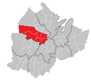
                Castle is one of the ten district electoral areas in Belfast, Northern Ireland. Located in the north of the city, the district elects six members to Belfast City Council and contains the wards of Bellevue, Cavehill, Chichester Park, Duncairn, Fortwilliam and Innisfayle. Castle, along with Oldpark district and parts of the Court district and Newtownabbey Borough Council, forms the Belfast North constituency for the Northern Ireland Assembly and UK Parliament. The district is bounded to the east by the Victoria Channel, to the north by Newtownabbey Borough Council and Belfast Lough, to the south by North Street and to the west by the Cavehill Road.

                <span class="mw-page-title-main">Court (District Electoral Area)</span>

                Court is one of the ten district electoral areas (DEA) in Belfast, Northern Ireland. Located in the north and west of the city, the district elects six members to Belfast City Council and contains the wards of Ballygomartin, Clonard, Falls, Forth River, Shankill, and Woodvale. Court is split between the Belfast North and Belfast West constituencies for the Northern Ireland Assembly and UK Parliament.

                Elections to Larne Borough Council were held on 5 May 2011 on the same day as the other Northern Irish local government elections. The election used three district electoral areas to elect a total of 15 councillors.

                Elections to Larne Borough Council were held on 7 June 2001 on the same day as the other Northern Irish local government elections. The election used three district electoral areas to elect a total of 15 councillors.

                Elections to Larne Borough Council were held on 21 May 1997 on the same day as the other Northern Irish local government elections. The election used three district electoral areas to elect a total of 15 councillors.

                <span class="mw-page-title-main">Castlereagh East (District Electoral Area)</span> Electoral area in Northern Ireland

                Castlereagh East is one of the seven district electoral areas (DEA) in Lisburn and Castlereagh, Northern Ireland. The district elects five members to Lisburn and Castlereagh City Council and contains the wards of Ballyhanwood, Carrowreagh, Dundonald, Enler, Graham's Bridge and Moneyreagh. Castlereagh East forms part of the Belfast East constituencies for the Northern Ireland Assembly and UK Parliament.

                <span class="mw-page-title-main">Lisburn North (District Electoral Area)</span> District electoral area in Northern Ireland

                Lisburn North is one of the seven district electoral areas (DEA) in Lisburn and Castlereagh, Northern Ireland. The district elects six members to Lisburn and Castlereagh City Council and contains the wards of Derryaghy, Harmony Hill, Hilden, Lambeg, Magheralave and Wallace Park. Lisburn North forms part of the Lagan Valley constituencies for the Northern Ireland Assembly and UK Parliament.

                <span class="mw-page-title-main">Dunmurry Cross (District Electoral Area)</span> District electoral areas in Ards, Northern Ireland

                Dunmurry Cross was one of the district electoral areas in Lisburn, Northern Ireland which existed from 1985 to 2014. It was one of four Lisburn DEAs until 1993, and one of five until 2014. The district elected seven members to Lisburn City Council and formed part of Belfast West constituencies for the Northern Ireland Assembly and UK Parliament and part of the Lagan Valley constituencies for the Northern Ireland Assembly and UK Parliament.

                <span class="mw-page-title-main">Ballyclare (District Electoral Area)</span> District electoral area in Northern Ireland

                Ballyclare is one of the seven district electoral areas (DEA) in Antrim and Newtownabbey, Northern Ireland. The district elects five members to Antrim and Newtownabbey Borough Council and contains the wards of Ballyclare East, Ballyclare West, Ballynure, Ballyrobert and Doagh. Ballyclare forms part of the South Antrim constituencies for the Northern Ireland Assembly and UK Parliament.

                Antrim Line was one of the district electoral areas in Newtownabbey, Northern Ireland which existed from 1985 to 2014, one of five DEAs until 1993 and one of four DEAs until 2014. The district elected five members to Newtownabbey Borough Council until 1993 and seven members until 2014, and formed part of the South Antrim constituencies for the Northern Ireland Assembly and UK Parliament and part of the Belfast North constituencies for the Northern Ireland Assembly and UK Parliament.

                <span class="mw-page-title-main">Antrim South East (District Electoral Area)</span> District electoral areas in Antrim, Northern Ireland

                Antrim South East was one of the three district electoral areas in Antrim, Northern Ireland which existed from 1985 to 2014. The district elected seven members to Antrim Borough Council and formed part of the South Antrim constituencies for the Northern Ireland Assembly and UK Parliament.

                <span class="mw-page-title-main">Kilroot (District Electoral Area)</span> District electoral areas in Carrickfergus, Northern Ireland

                Kilroot was one of the three district electoral areas in Carrickfergus, Northern Ireland which existed from 1985 to 2014. The district elected five members to Carrickfergus Borough Council from 1985 to 1993, and six members from 1993 to 2014, and formed part of the East Antrim constituencies for the Northern Ireland Assembly and UK Parliament.

                <span class="mw-page-title-main">Coast Road (District Electoral Area)</span> District electoral area in Northern Ireland

                Coast Road is one of the seven district electoral areas (DEA) in Mid and East Antrim, Northern Ireland. The district elects five members to Mid and East Antrim District Council and contains the wards of Cairncastle, Carnlough and Glenarm, Craigyhill, Gardenmore and The Maidens. Coast Road forms part of the East Antrim constituencies for the Northern Ireland Assembly and UK Parliament.

                <span class="mw-page-title-main">Braid (District Electoral Area)</span> District electoral area in Northern Ireland

                Braid is one of the seven district electoral areas (DEA) in Mid and East Antrim, Northern Ireland. The district elects seven members to Mid and East Antrim District Council and contains the wards of Ballee and Harryville, Broughshane, Glenravel, Glenwhirry, Kells, Kirkinriola and Slemish. Braid forms part of the North Antrim constituencies for the Northern Ireland Assembly and UK Parliament.

                <span class="mw-page-title-main">Bann Valley (District Electoral Area)</span> District electoral areas in Ballymoney, Northern Ireland

                Bann Valley was one of the three district electoral areas in Ballymoney, Northern Ireland which existed from 1985 to 2014. The district elected six members to Ballymoney Borough Council, and formed part of the North Antrim constituencies for the Northern Ireland Assembly and UK Parliament.

                <span class="mw-page-title-main">The Skerries (District Electoral Area)</span> District electoral areas in Coleraine, Northern Ireland

                The Skerries was one of the district electoral areas in Coleraine, Northern Ireland which existed from 1985 to 2014, one of three DEAs from 1985 to 1993 and one of four DEAs from 1993 to 2014. The district elected seven members to Coleraine Borough Council until 1993, and five until 2014, and formed part of the East Londonderry constituencies for the Northern Ireland Assembly and UK Parliament.

                <span class="mw-page-title-main">Benbradagh (District Electoral Area)</span> District electoral area in Northern Ireland

                Benbradagh is one of the seven district electoral areas (DEA) in Causeway Coast and Glens, Northern Ireland. The district elects five members to Causeway Coast and Glens Borough Council and contains the wards of Altahullion, Ballykelly, Dungiven, Feeny and Greysteel. Benbradagh forms part of the East Londonderry constituencies for the Northern Ireland Assembly and UK Parliament.

                <span class="mw-page-title-main">Banbridge (District Electoral Area)</span> District electoral area in Northern Ireland

                Banbridge is one of the seven district electoral areas (DEA) in Armagh City, Banbridge and Craigavon, Northern Ireland. The district elects seven members to Armagh City, Banbridge and Craigavon Borough Council and contains the wards of Banbridge East, Banbridge North, Banbridge South, Banbridge West, Gilford, Loughbrickland and Rathfriland. Banbridge forms part of the Upper Bann constituencies for the Northern Ireland Assembly and UK Parliament.

                <span class="mw-page-title-main">The Mournes (District Electoral Area)</span> District electoral area in Northern Ireland

                The Mournes is one of the seven district electoral areas (DEA) in Newry, Mourne and Down, Northern Ireland. The district elects seven members to Newry, Mourne and Down District Council and contains the wards of Annalong, Binnian, Donard, Kilkeel, Lisnacree, Murlough and Tollymore. The Mournes forms part of the South Down constituencies for the Northern Ireland Assembly and UK Parliament.

                <span class="mw-page-title-main">Waterside (District Electoral Area)</span> District electoral area in Northern Ireland

                Waterside is one of the seven district electoral areas (DEA) in Derry and Strabane, Northern Ireland. The district elects seven members to Derry and Strabane District Council and contains the wards of Caw, Clondermot, Drumahoe, Ebrington, Kilfennan, Lisnagelvin and Victoria. Waterside forms part of the Foyle constituencies for the Northern Ireland Assembly and UK Parliament.

                References

                1. "Larne Town Result Sheet" (PDF). EONI. Retrieved 8 July 2021.
                2. "Local Government Results 2005". EONI. Retrieved 8 July 2021.
                3. "Local Government Results 2001". EONI. Retrieved 8 July 2021.
                4. "Local Government Results 1997". EONI. Retrieved 8 July 2021.
                5. "Local Government Results 1993". EONI. Retrieved 8 July 2021.
                6. "Local Government Results 1989". EONI. Retrieved 8 July 2021.
                7. "Local Government Results 1985". EONI. Retrieved 8 July 2021.