
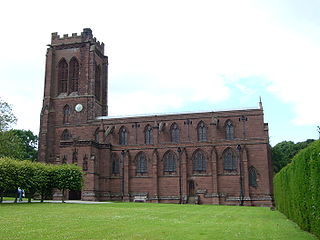
Chaddesden, also known locally as Chadd, is a large residential suburb of Derby, in the ceremonial county of Derbyshire, England. Historically a separate village centred on Chaddesden Hall and the 14th century St Mary's Church, the area was significantly expanded by 20th-century housing developments, and became part of the then County Borough of Derby in 1968, prior to Derby's city status in 1977.

Sherston is a village and civil parish about 5 miles (8 km) west of Malmesbury in Wiltshire, England. The parish is bounded to the north by the county boundary with Gloucestershire, and to the southeast by the Fosse Way, a Roman road. The parish includes the hamlets of Easton Town, immediately east of Sherston; Pinkney, further east along the Malmesbury road; and Willesley, to the north.

Badminton is a village and civil parish in South Gloucestershire, England. The only settlement in the parish is Badminton village, sometimes called Great Badminton to distinguish it from the hamlet of Little Badminton, about one mile to the north in Hawkesbury parish. The large country house called Badminton House is close to the north end of the village, and its surrounding deer park lies to the north and west.

Ambrosden is a village and civil parish in Cherwell, Oxfordshire, England, 3 miles (5 km) southwest of Bicester to which it is linked by the A41 road, and 13 miles (21 km) from Oxford. The 2011 Census recorded the parish's population as 2,248. The parish is bounded by the River Ray to the south, its tributary the River Bure to the west, the outskirts of Bicester to the north and field boundaries to the east.

Modbury is a large village, ecclesiastical parish, civil parish and former manor situated in the South Hams district of the county of Devon in England. Today due to its large size it is generally referred to as a "town" although the parish council has not elected to give itself the status of a town as it could do under s.245(6) of the Local Government Act 1972, so it does not have a town council and cannot have a town mayor. It is also known informally as a "market town", as from at least 1199 the lord of the manor has held the right to hold a regular market. The village is situated on the A379 road, which links it to Plymouth and Kingsbridge. The current parish population is approximately 1,500.

Siston is a small village in South Gloucestershire, England. It is 7 miles (11 km) east of Bristol at the confluence of the two sources of the Siston Brook, a tributary of the River Avon. The village consists of a number of cottages and farms centred on St Anne's Church, and the grand Tudor manor house of Siston Court. Anciently it was bordered to the west by the royal Hunting Forest of Kingswood, stretching westward most of the way to Bristol Castle, always a royal possession, caput of the Forest. The local part of the disafforested Kingswood became Siston Common but has recently been eroded by the construction of the Avon Ring Road and housing developments. In 1989 the village and environs were classed as a conservation area and thus have statutory protection from overdevelopment.

Tormarton is a village and civil parish in the South Gloucestershire district, in the ceremonial county of Gloucestershire, England. The village is about half a mile north of the M4 motorway; the A46 road towards Bath passes a similar distance west of the village to join the motorway at junction 18. The parish includes the small village of West Littleton, south of the motorway. The parish population at the 2021 census was 323. The Cotswold Way footpath passes through the village.
Alderley is a village and civil parish in the Stroud district of Gloucestershire, England, about fourteen miles southwest of Stroud and two miles south of Wotton-under-Edge. It is situated on the Cotswold Way near to the villages of Hillesley and Tresham and lies underneath Winner Hill between two brooks, the Ozleworth and Kilcott.

Arlingham is a village and civil parish in the Stroud District of Gloucestershire, England. The 2021 Census recorded a parish population of 533. The parish contains the hamlets of Milton End, Overton and Priding. The next parish to the east is Fretherne with Saul.
Eccleston is a village and former civil parish, now in the parish of Eaton and Eccleston, in the borough of Cheshire West and Chester, in the ceremonial county of Cheshire, England. The village is approximately 2.7 miles (4.3 km) to the south of the city of Chester, near to the River Dee. The village is situated on the estate of the Duke of Westminster who maintains his ancestral home at nearby Eaton Hall.

Cogges is an area beside the River Windrush in Witney, in the West Oxfordshire district, in Oxfordshire, England, 0.5 miles (800 m) east of the town centre. It had been a separate village and until 1932 it was a separate civil parish.

Great Barrington is a village and former civil parish, now in the parish of Barrington, in the Cotswold district of Gloucestershire, England. It lies in the north bank of the River Windrush, 3 miles (4.8 km) west of the town of Burford, Oxfordshire. In 1931 the parish had a population of 330.

Ospringe is a village and area of Faversham in the English county of Kent. It is also the name of a civil parish, which since 1935 has not included the village of Ospringe.

Chitterne is a village and civil parish in the county of Wiltshire, in the south west of England. The village lies in the middle of Salisbury Plain, about 7 miles (11 km) east of the town of Warminster.

Calcot Manor is a historic building in Calcot, three and a half miles west of Tetbury on A 4135 in Gloucestershire, England, near the junction of roads A46 and A4135. The original building was established in approximately 1300 AD by Henry of Kingswood as a tithe barn annex of Kingswood Abbey. The estate was expanded to include a 16th-century manor house and other buildings. Structures added from the Late Middle Ages to the mid-17th century include a chapel, granary, stables and other buildings. The buildings are all constructed from limestone; which are locally quarried stones that are typically flat and easily stacked for drystone wall purposes.

Fishbourne is a village and civil parish in the Chichester District of West Sussex, England and is situated two miles (3.2 km) west of Chichester.

Rendcomb is a village in the Cotswold local authority area of the English county of Gloucestershire. It is about five miles north of Cirencester in the Churn Valley.
Drayton is a village and civil parish in the valley of the Sor Brook in Oxfordshire, about 2 miles (3 km) northwest of Banbury. The 2011 Census recorded the parish's population as 242.

Leigh is a civil parish in the English county of Staffordshire. The parish includes the village of Church Leigh, together with the settlements of Withington, Upper Leigh, Lower Leigh, Morrilow Heath, Middleton Green, Dodsley, Godstone, Nobut and Field.
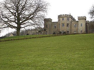
Lasborough Park is a Grade II listed country house in Newington Bagpath/Lasborough, Tetbury, Gloucestershire, England. The estate includes a medieval manor, a house, and parkland. The original medieval manor, Lasborough Farm, dates to the 11th century, and included terraced gardens. A manor house is record in the 14th century. The manor was surrounded by woodland and a deer park. Lasborough House and its pleasure grounds was built in 1794.

