
Waterloo is a city in the Canadian province of Ontario. It is one of three cities in the Regional Municipality of Waterloo. Waterloo is situated about 94 km (58 mi) southwest of Toronto. Due to the close proximity of the city of Kitchener to Waterloo, the two together are often referred to as "Kitchener–Waterloo" or the "Twin Cities".

The Regional Municipality of Waterloo is a metropolitan area of Southern Ontario, Canada. It contains the cities of Cambridge, Kitchener and Waterloo, and the townships of North Dumfries, Wellesley, Wilmot and Woolwich. Kitchener, the largest city, is the seat of government.

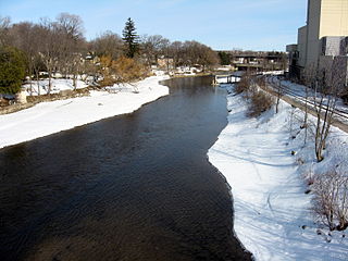
The Grand River formerly known as The River Ouse is a large river in Southwestern Ontario, Canada. It also lies along the western fringe of the Greater Golden Horseshoe region of Ontario which overlaps the eastern portion of southwestern Ontario, sometimes referred to as Midwestern Ontario, along the length of this river. From its source near Wareham, Ontario, it flows south through Grand Valley, Fergus, Elora, Waterloo, Kitchener, Cambridge, Paris, Brantford, Caledonia, and Cayuga before emptying into the north shore of Lake Erie south of Dunnville at Port Maitland. One of the scenic and spectacular features of the river is the falls and Gorge at Elora.

The Conestogo River is a river in Waterloo Region and Wellington County in Southwestern Ontario, Canada. The river was named by Mennonite settlers after the Conestoga River in Pennsylvania. In the 1800s there were several different spellings of the name of the river and of the nearby settlement of Conestogo, Ontario but the name ending in "o" became official.
The Speed River is a river that flows through Wellington County and the Region of Waterloo in southwestern Ontario, Canada. It flows south from its source near Orton, through Guelph, where it is joined by the Eramosa River, then through the towns of Hespeler and Preston, finally uniting with the Grand River in north-west Cambridge.

The Elora Cataract Trailway is a 47 km-long recreational rail trail between the towns of Elora and Forks of the Credit, in the south of the province of Ontario, Canada. The former Canadian National Railway line operated from about 1880 until 1988.

Big Six Mile Creek Marina is a 21-acre (0.085 km2) state park and marina located on the upper Niagara River on Grand Island in Erie County, New York.

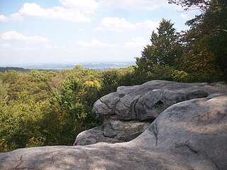
The Elora Gorge is a popular tourist attraction located at the western edge of Elora, Ontario, Canada, which is 25 km north from the city of Guelph through highway 6.
Forbes State Forest is a Pennsylvania state forest in Pennsylvania Bureau of Forestry District #4. The main offices are located in Laughlintown in Westmoreland County, Pennsylvania in the United States. Mount Davis, the highest peak in Pennsylvania, is located in the forest.

The Tonto Trail is a hiking trail on the South Rim of the Grand Canyon in Grand Canyon National Park, located in the U.S. state of Arizona.

The Grand River Conservation Authority (GRCA) is a conservation authority in Ontario, Canada. It operates under the Conservation Authorities Act of Ontario. It is a corporate body, through which municipalities, landowners and other organizations work cooperatively to manage the Grand River watershed and natural resources within it.

Guelph Lake is a man-made reservoir on the Speed River, in the Township of Guelph/Eramosa. It is located upriver and slightly northeast of the city of Guelph, Ontario. The reservoir was created in 1974, with the construction of the Guelph Lake dam. The site is part of a 1,608 hectare conservation area maintained by the Grand River Conservation Authority.

Colt Creek State Park is a Florida State Park in Central Florida, 16 miles (26 km) north of Lakeland off of State Road 471. This 5,067 acre park nestled within the Green Swamp Wilderness Area and named after one of the tributaries that flows through the property was opened to the public on January 20, 2007. Composed mainly of pine flatwoods, cypress domes and open pasture land, this piece of pristine wilderness is home to many animal species including the American bald eagle, Southern fox squirrel, gopher tortoise, white-tailed deer, wild turkey and bobcat.
Puslinch Lake is a kettle lake located in Wellington County, Ontario, Canada. It is the largest kettle lake in Canada. The lake is "private", according to Puslinch Township Council, but some public access was available near the trailer park until the owners closed both to the public in July 2020. In October 2020, Township of Puslinch announced that it "working towards creating a public access to Puslinch Lake".

Sunfish Lake is a small, 25 hectare meromictic lake located north-west of Waterloo, Ontario, in the village of St. Agatha in northern Wilmot Township, and is the source of Laurel Creek. It is one of a few meromictic lakes in Ontario, that is, its deep bottom waters are totally devoid of oxygen. The surface and bottom layers do not mix, and the lake is vulnerable to environmental damage.
Paul F. J. Eagles is an Emeritus Professor at the University of Waterloo in Canada. He is a Biologist and a Planner, specializing in environmental planning.
Ganaraska Region is a region located in Ontario, Canada, stretching along the shore of Lake Ontario for approximately 45 kilometres (28 mi) and about 15 kilometres (9.3 mi) wide. It contains watersheds, covering an area of 700 square kilometres (270 sq mi) from Wilmot Creek in Clarington to eastside of Cobourg and from the southern shore of Rice Lake down to Lake Ontario. This expansive area includes seven municipalities in whole or in part: Township of Cavan Monaghan, Town of Cobourg, Township of Alnwick/Haldimand, Township of Hamilton, Municipality of Port Hope, City of Kawartha Lakes, Municipality of Clarington.
The Cataraqui Region Conservation Authority is one of 36 conservation authorities in the Canadian province of Ontario. It is headquartered in Kingston, Ontario The authority was established by an Order in Council in December 1964 via the Conservation Authorities Act, and is a member authority of Conservation Ontario.

Waterloo Park is an urban park situated in Waterloo, Ontario, Canada on land within Block 2 of the Haldimand Tract. Spanning 111 acres within the Uptown area of Waterloo, it opened in 1893 and is the oldest park in the city. Managed by the City of Waterloo, the park contains numerous recreational amenities including athletic fields, baseball diamonds, playgrounds, a skateboard park, and the Laurel and Trans Canada trails.

Brubacher House is a historic house museum in Waterloo, Ontario, Canada which showcases the home life of 19th century Mennonite pioneers in Waterloo County. The house was built in 1850 or 1851 by the Mennonite community for the Brubacher family. It and its attached farmland were sold in 1965 to the University of Waterloo.
