
A hot spring, hydrothermal spring, or geothermal spring is a spring produced by the emergence of geothermally heated groundwater onto the surface of the Earth. The groundwater is heated either by shallow bodies of magma or by circulation through faults to hot rock deep in the Earth's crust. In either case, the ultimate source of the heat is radioactive decay of naturally occurring radioactive elements in the Earth's mantle, the layer beneath the crust.
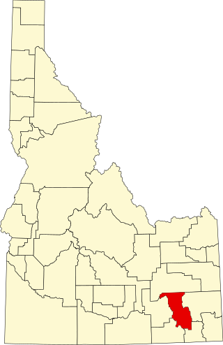
Bannock County is a county in the southeastern part of Idaho. As of the 2020 Census, the population was 87,018, making it the sixth-most populous county in Idaho. The county seat and largest city is Pocatello. The county was established in 1893 and named after the local Bannock tribe. It is one of the counties with territories included in the Fort Hall Indian Reservation of the federally recognized Shoshone-Bannock Tribes.
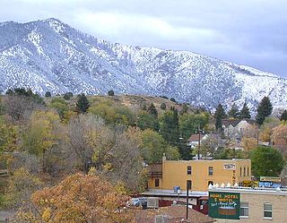
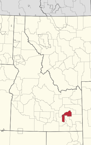
Lava Hot Springs is a city along the Portneuf River in eastern Bannock County, Idaho, United States. It is part of the Pocatello, Idaho metropolitan area. The population was 407 at the 2010 census, down from 521 in 2000. Located in the mountainous valley of the Portneuf River on the old route of the Oregon Trail and California Trail, the city has become a popular resort location, noted for its numerous hot springs amenable to bathing and a turbulent inner tube run through part of the town.

The geothermal areas of Yellowstone include several geyser basins in Yellowstone National Park as well as other geothermal features such as hot springs, mud pots, and fumaroles. The number of thermal features in Yellowstone is estimated at 10,000. A study that was completed in 2011 found that a total of 1,283 geysers have erupted in Yellowstone, 465 of which are active during an average year. These are distributed among nine geyser basins, with a few geysers found in smaller thermal areas throughout the Park. The number of geysers in each geyser basin are as follows: Upper Geyser Basin (410), Midway Geyser Basin (59), Lower Geyser Basin (283), Norris Geyser Basin (193), West Thumb Geyser Basin (84), Gibbon Geyser Basin (24), Lone Star Geyser Basin (21), Shoshone Geyser Basin (107), Heart Lake Geyser Basin (69), other areas (33). Although famous large geysers like Old Faithful are part of the total, most of Yellowstone's geysers are small, erupting to only a foot or two. The hydrothermal system that supplies the geysers with hot water sits within an ancient active caldera. Many of the thermal features in Yellowstone build up sinter, geyserite, or travertine deposits around and within them.

A spring is a natural exit point at which groundwater emerges out of the aquifer and flows onto the top of the Earth's crust (pedosphere) to become surface water. It is a component of the hydrosphere as well as a part of the water cycle. Springs have long been important for humans as a source of fresh water, especially in arid regions which have relatively little annual rainfall.
The Fort Hall Reservation is a Native American reservation of the federally recognized Shoshone-Bannock Tribes in the U.S. state of Idaho. This is one of five federally recognized tribes in the state. The reservation is located in southeastern Idaho on the Snake River Plain about 20 miles (32 km) north and west of Pocatello. It comprises 814.874 sq mi (2,110.51 km2) of land area in four counties: Bingham, Power, Bannock, and Caribou. To the east is the 60-mile-long (97 km) Portneuf Range; both Mount Putnam and South Putnam Mountain are located on the Fort Hall Reservation.
Coso Hot Springs is a hot spring complex in the Coso Volcanic Field in the Mojave Desert of Inyo County, California. The Springs are on the National Register of Historic Places.

Stanley Hot Springs is a series of thermal springs located in the Selway–Bitterroot Wilderness in Idaho County, Idaho, United States.

McCredie Springs are hot springs and a former resort in Lane County, Oregon, United States. It is located near Oregon Route 58, 10.7 miles (17.2 km) east of Oakridge, and 50.7 miles (81.6 km) east of Eugene, within the Willamette National Forest. It is known for the nearby natural hot springs along Salt Creek.

Verde Hot Springs is a grouping of thermal mineral springs near the town of Camp Verde in Yavapai County, Arizona. The springs are located at the western bank of the Verde River. There are ruins of a former historical resort at the site and bathhouse.

Mystic Hot Springs, previously known as Monroe Hot Springs and Cooper Hot Springs are located in northeastern Monroe, Utah. The hot mineral water emerges from the spring at 168 °F (76 °C). The water flows into two smaller pools with temperatures between 92 and 102 °F.
Desert Hot Springs is a geothermal geographic area in Riverside County, California with several hot springs. Since 1941, the California Department of Conservation has recorded approximately 200 geothermal wells that have been drilled in this geographic area; approximately 50 of which are used for commercial spas and pools.

Sunflower Hot Springs is a geothermal mineral spring in Boise National Forest, Idaho, U.S.

Chena Hot Springs are a system of thermal mineral springs located within the Yukon-Tanana Plateau near the town of Chena Hot Springs, approximately 50 miles northeast of Fairbanks, Alaska.

Baker Hot Springs are a series of geothermal spring located on Fumarole Butte, northwest of the town of Delta, Utah. They were formerly known as Crater Springs and Abraham Hot Springs.

Crystal Springs hot springs is a system of geothermal springs and seeps near Ash Springs, located at the site of a ghost town, Crystal Springs, Nevada. Several marshes and springs are located along the White River.

Breitenbush Hot Springs, also known as Breitenbusher Hot Springs, is a thermal mineral spring system along the Breitenbush River near the historic town of Breitenbush, Oregon, United States.
Frenchman's Hot Springs, also known as Frenchman's Bend Hot Springs or Warfield Hot Springs, is a hot spring located along Warm Springs Creek in the Sawtooth National Forest, 11 miles (17.7km) from Ketchum, Idaho. The springs are composed of three wide, shallow pools. The pools are rock-walled, with sand and gravel covered bottoms. The average temperature of the springs varies throughout the year, but most of the time, water enters the springs at around 124°F (51.11°C). The water in the springs is usually clear.

Gregson Hot Springs also known as Fairmont Hot Springs, is a geothermal hot spring system located in Silver Bow County, Montana. Over the years the mineral-rich hot spring water was thought to relieve rheumatism and arthritis among other ailments.


