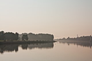
The Drava or Drave, historically known as the Dravis or Dravus, is a river in southern Central Europe. With a length of 710km, or 724km, if the length of its Sextner Bach source is added, it is the fifth or sixth longest tributary of the Danube, after the Tisza, Sava, Prut, Mureș and likely Siret. The Drava drains an area of about 40,154 square kilometers. Its mean annual discharge is seasonally 500m³/s to 670m³/s. Its source is near the market town of Innichen, in the Puster Valley of South Tyrol, Italy. The river flows eastwards through East Tyrol and Carinthia in Austria into the Styria region of Slovenia. It then turns southeast, passing through northern Croatia and, after merging with its main tributary the Mur, forms most of the border between Croatia and Hungary, before it joins the Danube near Osijek, in Croatia.

Carinthia is the southernmost and least densely populated Austrian state, in the Eastern Alps, and is noted for its mountains and lakes. The main language is German. Its regional dialects belong to the Southern Bavarian group. Carinthian Slovene dialects, forms of a South Slavic language that predominated in the southeastern part of the region up to the first half of the 20th century, are now spoken by a small minority in the area.

Carinthia, also Slovene Carinthia or Slovenian Carinthia, is a traditional region in northern Slovenia. The term refers to the small southeasternmost area of the former Duchy of Carinthia, which after World War I was allocated to the State of Slovenes, Croats and Serbs according to the 1919 Treaty of Saint-Germain. It has no distinct centre, but a local centre in each of the three central river valleys among the heavily forested mountains.

The Meža (Slovene) or Mieß is a river in the Austrian state of Carinthia and in Slovenia, a right tributary of the Drava. It is 43 kilometers (27 mi) long, of which 42 kilometers (26 mi) are in Slovenia. Its catchment area is 551.7 square kilometers (213.0 sq mi), of which 543 square kilometers (210 sq mi) in Slovenia.
Wolfsberg is a town in Carinthia, Austria, the capital of Wolfsberg District.
The Bezirk Lienz is an administrative district (Bezirk) in Tyrol, Austria. It is the only district in East Tyrol. The district borders the Pinzgau (Salzburg) in the north, the districts Spittal an der Drau and Hermagor in the east, Veneto (Italy) in the south, and South Tyrol (Italy) in the west.

The Diocese of Lavant was a suffragan bishopric of the Archdiocese of Salzburg, established in 1228 in the Lavant Valley of Carinthia.

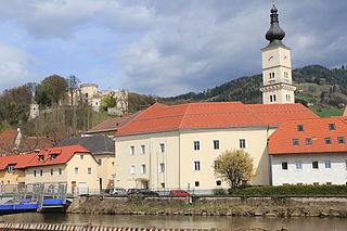
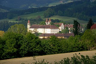
Saint Paul's Abbey in Lavanttal is a Benedictine monastery established in 1091 near the present-day market town of Sankt Paul im Lavanttal in the Austrian state of Carinthia. The premises centered on the Romanesque monastery church were largely rebuilt in a Baroque style in the 17th century.

The Lavant Viaduct is a motorway bridge crossing the Lavant River on the A2 motorway in Carinthia, Austria. With a length of 1,097 m and height of 165 m, it is also the second-highest bridge in Austria.
Sankt Paul im Lavanttal is a municipality of the Wolfsberg district in the Austrian state of Carinthia.

Griffen is a market town in the district of Völkermarkt in the Austrian state of Carinthia.

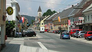
Bad Sankt Leonhard im Lavanttal is a spa town in the district of Wolfsberg in the Austrian state of Carinthia.
Lavamünd is a market town in the district of Wolfsberg in the Austrian state of Carinthia.
Sankt Georgen im Lavanttal is a town in the district of Wolfsberg in the Austrian state of Carinthia.

The Lavanttal lies in the Lavanttal Alps in southern Austria in the eastern part of the state of Carinthia. It covers just under 1,000 km2 (390 sq mi). Approximately 60,000 people live in the area.
Siegfried I is considered the progenitor of the Carinthian ducal House of Sponheim (Spanheimer) and all of its lateral branches, including the Counts of Lebenau and the Counts of Ortenburg. He is documented as Count of Sponheim from 1044 and served as margrave of the Hungarian March in 1045/46 and as count in the Puster Valley and the Lavant Valley from 1048 until his death.

The Koralm Railway is an Austrian 127 km-long (79 mi) double-track, electrified, high-speed railway currently under construction. It will connect the cities of Graz and Klagenfurt. Construction started in 2001; the entire railway line is expected to be operational in December 2025.

The Gurktal Alps is a mountain range in the Central Eastern Alps in Austria which is named after the valley of the Gurk river. The range stretches west to Lake Millstatt and east to Neumarkter Sattel. The highest peak is Eisenhut at 2,441m .

The Lavanttal Alps are part of the Central Eastern Alps in Austria and Slovenia, between the river Mur in the north and the Drava in the south.

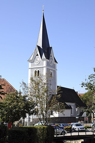
St. Andrew's Church, Sankt Andrä im Lavanttal, formerly Sankt Andrä Cathedral is a Roman Catholic church in Sankt Andrä im Lavanttal at the southern end of the Lavant Valley, Carinthia, Austria. For more than 600 years, between 1228 and 1859, it was the cathedral of the Diocese of Lavant.

