Lavoisier Island

Last updated
Lavoisier Island
Antarctica location map.svg
Red pog.svg
Lavoisier Island
Geography
Location Antarctica
Coordinates 66°12′S66°44′W / 66.200°S 66.733°W / -66.200; -66.733 Coordinates: 66°12′S66°44′W / 66.200°S 66.733°W / -66.200; -66.733
Archipelago Biscoe Islands
Length29 km (18 mi)
Width8 km (5 mi)
Administration
Administered under the Antarctic Treaty System

Lavoisier Island is an island 29 km (18 mi) long and 8 km (5 mi) wide, lying between Rabot and Watkins Islands in the Biscoe Islands, Antarctica. It is separated from Renaud Island and Rabot Island to the northeast by Pendleton Strait, from Watkins Island to the southwest by Lewis Sound, and from Krogh Island to the west-southwest by Vladigerov Passage.

Rabot Island island

Rabot Island is an island 8 km (5 mi) long and 3 km (2 mi) wide, lying 1.6 km (1 mi) south of Renaud Island in the Biscoe Islands. First charted by the French Antarctic Expedition, 1903–05, under Jean-Baptiste Charcot, who named it for Charles Rabot.

Watkins Island island

Watkins Island is a low lying, ice-covered island 5 miles (8 km) long, lying 3 miles (5 km) SW of Lavoisier Island in the Biscoe Islands. The island was first mapped by the French Antarctic Expedition under Jean-Baptiste Charcot, 1903–05 and 1908–10, but remained unnamed until resighted by the BGLE under Rymill, 1934–37. He gave the name Mikkelsen Island after Ejnar Mikkelsen, Danish Arctic explorer. In applying the name, Rymill was unaware of the existence of Mikkelsen Islands 75 mi (121 km) southwestward, named in 1908–10 by Charcot. To avoid confusion of the two, the UK-APC recommended in 1952 that the Rymill naming be amended. The new name, Watkins Island, commemorates Gino Watkins, leader of the British Arctic Air Route Expedition, 1930–31. A new feature, Mikkelsen Bay, has been named for Ejnar Mikkelsen.

Biscoe Islands archipelago

Biscoe Islands is a series of islands, of which the principal ones are Renaud, Lavoisier, Watkins, Krogh, Pickwick and Rabot, lying parallel to the west coast of Graham Land and extending 150 km (81 nmi) between Southwind Passage on the northeast and Matha Strait on the southwest. Another group of islands are the Adolph Islands.

Contents

Lavoisier Island is named Isla Serrano by Chile and isla Mitre by Argentina.

Chile Republic in South America

Chile, officially the Republic of Chile, is a South American country occupying a long, narrow strip of land between the Andes to the east and the Pacific Ocean to the west. It borders Peru to the north, Bolivia to the northeast, Argentina to the east, and the Drake Passage in the far south. Chilean territory includes the Pacific islands of Juan Fernández, Salas y Gómez, Desventuradas, and Easter Island in Oceania. Chile also claims about 1,250,000 square kilometres (480,000 sq mi) of Antarctica, although all claims are suspended under the Antarctic Treaty.

Argentina federal republic in South America

Argentina, officially the Argentine Republic, is a country located mostly in the southern half of South America. Sharing the bulk of the Southern Cone with Chile to the west, the country is also bordered by Bolivia and Paraguay to the north, Brazil to the northeast, Uruguay and the South Atlantic Ocean to the east, and the Drake Passage to the south. With a mainland area of 2,780,400 km2 (1,073,500 sq mi), Argentina is the eighth-largest country in the world, the fourth largest in the Americas, and the largest Spanish-speaking nation. The sovereign state is subdivided into twenty-three provinces and one autonomous city, Buenos Aires, which is the federal capital of the nation as decided by Congress. The provinces and the capital have their own constitutions, but exist under a federal system. Argentina claims sovereignty over part of Antarctica, the Falkland Islands, and South Georgia and the South Sandwich Islands.

The island was first charted by the French Antarctic Expedition, 1903–05, under Jean-Baptiste Charcot, and named "Ile Nansen" after Fridtjof Nansen, Norwegian Arctic explorer. To avoid confusion with Nansen Island (q.v.) in Wilhelmina Bay, the UK-APC recommended in 1960 that the island be renamed for Antoine Laurent Lavoisier, French chemist who pioneered the study of metabolism.

The French Antarctic Expedition is any of several French expeditions in Antarctica.

Jean-Baptiste Charcot French scientist

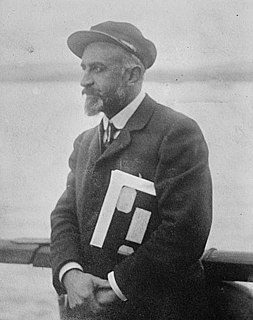
Jean-Baptiste-Étienne-Auguste Charcot, born in Neuilly-sur-Seine, was a French scientist, medical doctor and polar scientist. His father was the neurologist Jean-Martin Charcot (1825–1893).

Fridtjof Nansen Norwegian polar explorer and Nobel Peace Prize laureate

Fridtjof Wedel-Jarlsberg Nansen was a Norwegian explorer, scientist, diplomat, humanitarian and Nobel Peace Prize laureate. In his youth he was a champion skier and ice skater. He led the team that made the first crossing of the Greenland interior in 1888, traversing the island on cross-country skis. He won international fame after reaching a record northern latitude of 86°14′ during his Fram expedition of 1893–1896. Although he retired from exploration after his return to Norway, his techniques of polar travel and his innovations in equipment and clothing influenced a generation of subsequent Arctic and Antarctic expeditions.

Winslow Rock

Winslow Rock is a rock close off the east side of Lavoisier Island, Biscoe Islands. Mapped from surveys by Falkland Islands Dependencies Survey (FIDS) (1958–59). There is a small penguin rookery on this rock, which provides the only known landing place on the east side of Lavoisier Island. Named by United Kingdom Antarctic Place-Names Committee (UK-APC) for Charles E.A. Winslow, American physiologist who has specialized in the reactions of the human body to cold environments.

See also

Related Research Articles

Enterprise Island

Enterprise Island or Isla Lientur or Isla Nansen Norte or North Nansen Island is an island that is 2.8 kilometres (1.5 nmi) long and lies at the northeast end of Nansen Island in Wilhelmina Bay, off the west coast of Graham Land. Today, a visit to Enterprise Island is often part of Antarctic cruises.

Renaud Island

Renaud Island is an ice-covered island, 40 km (25 mi) long and from 6.4 to 16.1 km wide, lying between the Pitt Islands and Rabot Island in the Biscoe Islands of Antarctica. It is separated from Pitt Islands to the northeast by Mraka Sound, and from Lavoisier Island to the southwest by Pendleton Strait. Zubov Bay is a 2.5 mile bay that indents the east side of the island.

Zukriegel Island

Zukriegel Island is an island 1.9 km (1 nmi) long, lying between Rabot Island and Hennessy Islands, in the Biscoe Islands. First accurately shown on an Argentine government chart of 1957. Named by the United Kingdom Antarctic Place-Names Committee (UK-APC) in 1959 for Josef Zukriegel, Czechoslovakian geographer who specialized in sea ice studies.

Atwater Hill is a hill in Antarctica, 2.5 miles (4 km) south of Benedict Point on the east side of Lavoisier Island, Biscoe Islands. It was mapped from air photos by the Falkland Islands and Dependencies Aerial Survey Expedition (1956–57), and named by the UK Antarctic Place-Names Committee for Wilbur Olin Atwater, an American physiologist who, with Francis Gano Benedict, perfected the technique for calorimetric measurement of metabolism.

Long Rock, Livingston Island rock at Livingston Island

Long Rock is a large rock extending 720 m (787 yd) in east-west direction, 180 m (197 yd) wide and rising to 13 m (42.7 ft) in the northeast of Morton Strait in the South Shetland Islands, Antarctica. The area was visited by early 19th century sealers operating on Byers Peninsula.

Wittmann Island is an island lying 2 nautical miles (3.7 km) west-southwest of Nusser Island, off the east side of Renaud Island in the Biscoe Islands. First accurately shown on an Argentine government chart of 1957, it was named by the United Kingdom Antarctic Place-Names Committee (UK-APC) in 1959 after Walter I. Wittmann, an American oceanographer who has specialized in sea ice studies.

Belding Island is an island 3 nautical miles (6 km) long, lying west of the south end of Watkins Island, Biscoe Islands. It was mapped from air photos taken by the Falkland Islands and Dependencies Aerial Survey Expedition (1956–57), and named by the UK Antarctic Place-Names Committee for Harwood S. Belding, an American physiologist who was Director of the Quartermaster at the Climatic Research Laboratory, Department of the Army, Lawrence, Massachusetts, and initiated considerable research on cold climate clothing.

Vize Islands

Vize Islands is a group of small islands lying 4.6 km (2.5 nmi) south of Karelin Islands, off the east side of Renaud Island in the Biscoe Islands. First accurately shown on an Argentine government chart of 1957. Named by the United Kingdom Antarctic Place-Names Committee (UK-APC) in 1959 for Vladimir Vize, Soviet climatologist and oceanographer, a pioneer of ice forecasting methods and author of numerous works on sea ice in the Arctic.

Krogh Island

Krogh Island is an ice-covered island about 5 nautical miles (9 km) long lying close west of the southern part of Lavoisier Island in Biscoe Islands, Antarctica. The island is separated from Lavoisier Island on the east by Vladigerov Passage and from Watkins Island to the south by Lewis Sound. Its north coast is indented by Transmarisca Bay and Suregetes Cove.

Phelps Rock is an insular rock rising 10 m above sea level southwest of Hugo Island, in the west approaches to French Passage, Wilhelm Archipelago. The rock was charted by a Royal Navy Hydrographic Survey Unit from HMS Protector, 1966-67. Named by United Kingdom Antarctic Place-Names Committee (UK-APC) after Captain Edmund M.S. Phelps, First Officer in John Biscoe, 1966-72, who assisted with the hydrographic survey of the area, 1965-67.

Pickwick Island

Pickwick Island is the largest of the Pitt Islands, in the Biscoe Islands, Antarctica. It is 9.45 km long in southwest-northeast direction, separated from Renaud Island on the southwest by Mraka Sound, and has its northeast coast indented by Misionis Bay.

Scholander Island is an island 1.5 nautical miles (2.8 km) east of Watkins Island, Biscoe Islands. Mapped from air photos taken by Falkland Islands and Dependencies Aerial Survey Expedition (FIDASE) (1956–57). Named by United Kingdom Antarctic Place-Names Committee (UK-APC) for Per F. Scholander, American physiologist who has investigated many aspects of polar physiology.

Schule Island is a small island lying 4 nautical miles (7 km) east of Laktionov Island, off the east side of Renaud Island in the Biscoe Islands. First accurately shown on an Argentine government chart of 1957. Named by the United Kingdom Antarctic Place-Names Committee (UK-APC) in 1959 for John J. Schule, Jr., American oceanographer who organized the sea ice service of the U.S. Hydrographic Office in 1950.

Rodman Passage is a passage between the south end of Renaud Island and Rabot Island, in the Biscoe Islands. Charted by the French Antarctic Expedition under Charcot, 1908-10. Named by the United Kingdom Antarctic Place-Names Committee (UK-APC) in 1959 for Hugh Rodman of the U.S. Hydrographic Office, author in 1890 of Reports of Ice and Ice Movements in the North Atlantic, a pioneer work on the subject.

Lewis Sound

Lewis Sound is a body of water running northwest–southeast between Lavoisier Island and Krogh Island to the northeast and Watkins Island to the southwest, in the Biscoe Islands of Antarctica. It was mapped from aerial photographs taken by the Falkland Islands and Dependencies Aerial Survey Expedition, 1956–57. In association with the names of pioneers in cold climate physiology grouped in this area, it was named "Lewis Passage" by the UK Antarctic Place-Names Committee (1960) after Sir Thomas Lewis, an English physiologist who investigated the responses of the blood vessels of the skin to environmental temperature. The feature was later renamed as Lewis Sound as it does not provide safe passage for a ship.

Vladigerov Passage

Vladigerov Passage is the passage long 5.8 km in southwest-northeast direction and 1.05 km wide in Biscoe Islands, Antarctica between Lavoisier Island on the east and Krogh Island on the west. The eponymous Vladigerov Island, 420 m long in southwest-northeast direction and 150 m wide, is lying in the narrowest part of the passage centred at 66°17′17″S66°54′35″W, formed as a result of the retreat of the ice cap of Lavoisier Island in the early 21st century.

References