Le'auva'a

Last updated
Le'auva'a
Village
Samoa location map.svg
Red pog.svg
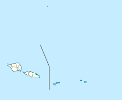
Le'auva'a
Location in Samoa
Coordinates: 13°48′00″S171°52′19″W / 13.80000°S 171.87194°W / -13.80000; -171.87194
Country Flag of Samoa.svg  Samoa
District Gaga'emauga
Population
 (2016)
  Total3,274
Time zone -11

Le'auva'a ('the people from the boat') [1] is a village on the island of Upolu in Samoa. The population is 3274. [2]

Although the village, with an area of 5.558 km2, [3] is geographically located on Upolu, the village is politically (and historically) part of the political district of Gaga'emauga on the island of Savai'i, [4] as is the neighbouring village of Saleimoa. The village was founded by people relocated to Upolu during the 1905—1911 eruption of Mt Matavanu, with Le'auva'a being founded by villagers from Mauga and Samalaeʻulu. [1]

Salamumu is another settlement on Upolu island which was also relocated from Savai'i following the volcanic eruptions.

Le'auva'a is part of the electoral constituency (faipule district) of Sagaga 3. [5]

Notable people

Related Research Articles

<span class="mw-page-title-main">Savaiʻi</span> Island in the Samoan Islands chain

Savaiʻi is the largest and highest island both in Samoa and in the Samoan Islands chain. The island is also the sixth largest in Polynesia, behind the three main islands of New Zealand and the Hawaiian Islands of Hawaii and Maui. While it is larger than the second main island, Upolu, it is significantly less populated.

<span class="mw-page-title-main">Manono Island</span> Island in Western Samoa

Manono is an island of Samoa, situated in the Apolima Strait between the main islands of Savai'i and Upolu, 3.4 km west-northwest off Lefatu Cape, the westernmost point of Upolu. By population, as well as by area, it is Samoa’s third largest island.

<span class="mw-page-title-main">Districts of Samoa</span> Overview of the districts of Samoa

Samoa is made up of eleven itūmālō. These are the traditional eleven districts that were established well before European arrival. Each district has its own constitutional foundation (faavae) based on the traditional order of title precedence found in each district's faalupega.

<span class="mw-page-title-main">Aiga-i-le-Tai</span> District in Samoa

Aiga-i-le-Tai is a district of Samoa which includes the small islands of Manono, Apolima and tiny uninhabited Nu'ulopa lying in the Apolima Strait between the country's two main islands of Upolu and Savai'i.

<span class="mw-page-title-main">Gagaʻemauga</span> District in Samoa

Gagaʻemauga is a district on the island of Savaiʻi in Samoa. The district is situated on the central north side of Savaiʻi. The name 'Gagaʻemauga' literally means "near side of the mountain", meaning the eastern side of the mountain chain running through the centre of Savaiʻi Island.

<span class="mw-page-title-main">Gagaʻifomauga</span> District in Samoa

Gagaʻifomauga is a political district on the island of Savaiʻi in Samoa. The district is situated on the northern side of the island with a population of 4,878.

Auala is a small village on the northwest coast of Savai'i island in Samoa. The village is in the electoral constituency of Vaisigano East which forms part of the larger political district of Vaisigano. The village's population was 507 in 2016, a decrease from 573 in 2011.

<span class="mw-page-title-main">Falelima</span> Village in Vaisigano, Samoa

Falelima is a village on the southwest corner of Savai'i island in Samoa. The village is part of the electoral constituency Alataua West which forms part of the larger political district of Vaisigano. The village's population is 412.

Salamumu is a village on the south west coast of Upolu island in Samoa. The village has two settlements, Salamumu Uta and Salamumu Tai.

Faleasi'u is one of the largest village settlements on the island of Upolu in Samoa. It is located on the northwestern coast of the island and has a population of 4177.

<span class="mw-page-title-main">Aopo</span> Village & Sub-district in Gagaifomauga, Samoa

Aopo is a village in the Gaga'ifomauga district on the island of Savai'i in Samoa. It is situated inland in the central north of the island in the district of Gagaʻifomauga and the electoral district of Gagaʻifomauga 3. The population is 383. The name of the village is derived from two words, ao (day) and po (night) and may be derived from a volcanic eruption.

Apai is one of four small villages on Manono Island in Samoa, in central South Pacific Ocean. The village population is 124.

Faleu is one of four small historic villages on Manono Island in Samoa in central South Pacific Ocean. The village population is 250.

Salua is one of four small villages on Manono Island in Samoa, in central South Pacific Ocean. The village population is 136.

Satapuala is a village situated on the north west coast Upolu island in Samoa. The village is part of A'ana Alofi 4 Electoral Constituency which forms part of the larger political district A'ana. It has a population of 1963.

<span class="mw-page-title-main">Saleaula</span> Village in Gagaemauga, Samoa

Sale'aula is a village on the central north coast of Savai'i island in Samoa and is the traditional center of the Gaga'emauga political district. Chief council meetings are held at Vaitu’utu’u malae in the village. The village has a population of 600.

<span class="mw-page-title-main">Mount Matavanu</span> Volcano in Savaii, Samoa

Mt Matavanu is an active volcano on the island of Savai'i in Samoa. The volcano was formed during an eruption in 1905. Lava flows from the eruption covered a large area of land in the Gaga'emauga district, leading to the relocation of several villages.

<span class="mw-page-title-main">Apolima Tai</span> Village in Aiga-i-le-Tai district, Western Samoa

Apolima Tai is a village on the small volcanic island of Apolima in Samoa, on the north side in the political district of Aiga-i-le-Tai. Its population is 96. Apolima island is one of three in the Apolima Strait between Samoan's two main islands, Upolu and Savai'i. The others are Manono, which has four villages, and uninhabited Nu'ulopa.

Lepuia'i is one of four small villages on Manono Island in Samoa in central South Pacific Ocean. The village population is 183.

<span class="mw-page-title-main">Samalaeʻulu</span>

Samalaeʻulu is a village on the northeast side of Savaiʻi island in Samoa. The village is situated on the main island highway about a 40-minutes drive north west from Salelologa ferry terminal and township and is part of the electoral constituency of Gaga'emauga 1. The population is 1054, making it one of the more populous villages in Savai'i.

References

  1. 1 2 Fepuleai, Aleni; Weber, Eberhard; Nemeth, Karoly; Muliaina, Tolu (2016). "Eruption Styles of Samoan Volcanoes Represented in Tattooing, Language and Cultural Activities of the Indigenous People". Geoheritage. 9 (3): 395-411. doi:10.1007/s12371-016-0204-1. S2CID   164339457 . Retrieved 30 July 2021.
  2. "Census 2016 Preliminary count" (PDF). Samoa Bureau of Statistics. Retrieved 3 August 2021.
  3. , page 56
  4. "Samoa Territorial Constituencies Act 1963". Pacific Islands Legal Information Institute. Archived from the original on 5 June 2011. Retrieved 15 December 2009.
  5. "Electoral Constituencies Act 2019" (PDF). Parliament of Samoa. 31 January 2019. Retrieved 11 September 2021.