
Mount St. Helens is an active stratovolcano located in Skamania County, Washington, in the Pacific Northwest region of the United States. It lies 52 miles (83 km) northeast of Portland, Oregon, and 98 miles (158 km) south of Seattle. Mount St. Helens takes its English name from that of the British diplomat Alleyne Fitzherbert, 1st Baron St Helens, a friend of explorer George Vancouver who surveyed the area in the late 18th century. The volcano is part of the Cascade Volcanic Arc, a segment of the Pacific Ring of Fire.

The Mono–Inyo Craters are a volcanic chain of craters, domes and lava flows in Mono County, Eastern California. The chain stretches 25 miles (40 km) from the northwest shore of Mono Lake to the south of Mammoth Mountain. The Mono Lake Volcanic Field forms the northernmost part of the chain and consists of two volcanic islands in the lake and one cinder cone volcano on its northwest shore. Most of the Mono Craters, which make up the bulk of the northern part of the Mono–Inyo chain, are phreatic volcanoes that have since been either plugged or over-topped by rhyolite domes and lava flows. The Inyo volcanic chain form much of the southern part of the chain and consist of phreatic explosion pits, and rhyolitic lava flows and domes. The southernmost part of the chain consists of fumaroles and explosion pits on Mammoth Mountain and a set of cinder cones south of the mountain; the latter are called the Red Cones.

Kīlauea is an active shield volcano in the Hawaiian Islands. It is located along the southeastern shore of Hawaii Island. The volcano is between 210,000 and 280,000 years old and grew above sea level about 100,000 years ago. Since the islands were settled it has been the most active of the five volcanoes that together form the island.

The Yellowstone Caldera, sometimes referred to as the Yellowstone Supervolcano, is a volcanic caldera and supervolcano in Yellowstone National Park in the Western United States. The caldera and most of the park are located in the northwest corner of Wyoming. The caldera measures 43 by 28 miles, and postcaldera lavas spill out a significant distance beyond the caldera proper.

Mount Mazama is a complex volcano in the western U.S. state of Oregon, in a segment of the Cascade Volcanic Arc and Cascade Range. Most of the mountain collapsed following a major eruption approximately 7,700 years ago. The volcano is in Klamath County, in the southern Cascades, 60 miles (97 km) north of the Oregon–California border. Its collapse, due to the eruption of magma emptying the underlying magma chamber, formed a caldera that holds Crater Lake. Mount Mazama originally had an elevation of 12,000 feet (3,700 m), but following its climactic eruption this was reduced to 8,157 feet (2,486 m). Crater Lake is 1,943 feet (592 m) deep, the deepest freshwater body in the U.S. and the second deepest in North America after Great Slave Lake in Canada.

Belknap Crater is a shield volcano in the Cascade Range in the U.S. state of Oregon. Located in Linn County, it is associated with lava fields and numerous subfeatures including the Little Belknap and South Belknap volcanic cones. It lies north of McKenzie Pass and forms part of the Mount Washington Wilderness. Belknap is not forested and most of its lava flows are not vegetated, though there is some wildlife in the area around the volcano, as well as a number of tree molds formed by its eruptive activity.
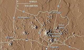
The San Francisco volcanic field is an area of volcanoes in northern Arizona, north of Flagstaff, US. The field covers 1,800 square miles (4,700 km2) of the southern boundary of the Colorado Plateau. The field contains 600 volcanoes ranging in age from nearly 6 million years old to less than 1,000 years, of which Sunset Crater is the youngest. The highest peak in the field is Humphreys Peak, at Flagstaff's northern perimeter: the peak is Arizona's highest at 12,633 feet and is a part of the San Francisco Peaks, an active stratovolcano complex.

The Poás Volcano, is an active 2,697-metre (8,848 ft) stratovolcano in central Costa Rica and is located within Poas Volcano National Park. It has erupted 40 times since 1828, including April 2017 when visitors and residents were evacuated. The volcano and surrounding park were closed for nearly 17 months, with a 2.5 kilometer safety perimeter established around the erupting crater. On September 1, 2018, the park reopened with limited access only to the crater observation area and required a reservation to be made on the National Park Website. Adjacent trails to Lake Botos as well as the museum at the visitor center remained closed. The volcano erupted briefly twice in September 2019.

The Capelinhos is a monogenetic volcano located on the western coast of Faial Island in the Azores. It is part of the larger volcanic complex of Capelo, which includes 20 scoria cones and lava fields that are aligned west-northwest to east-southeast from the Caldeira Volcano caldera. Although the name "Capelinhos" is associated with the volcano, it technically refers to the western cape of the parish of Capelo. It can be considered the westernmost point of Europe; there are more westerly islands in the Azores archipelago but they lie on the North American Plate.

Niuafoʻou is the northernmost island in the kingdom of Tonga. One of the Niua Islands, it is located in the southern Pacific Ocean between Fiji and Samoa, 574 km (357 mi) north of Tongatapu island group and 337 km (209 mi) northwest of Vavaʻu. It is a volcanic rim island with an area of 15 km2 (5.8 sq mi) and a population of 431. The volcano is active and has erupted regularly since 1814, with its last major eruption in 1985.

Cuicocha is a 3 km (2 mi) wide caldera and crater lake at the foot of Cotacachi Volcano in the Cordillera Occidental of the Ecuadorian Andes.

Mount Yasur is a volcano on Tanna Island, Vanuatu, 361 m (1,184 ft) high above sea level, on the coast near Sulphur Bay, northeast of the taller Mount Tukosmera, which was active in the Pleistocene. It has a largely unvegetated pyroclastic cone with a nearly circular summit crater 400 m in diameter.
Mount Edziza, sometimes called Edziza Mountain or Edziza Peak, is a stratovolcano in Cassiar Land District of northwestern British Columbia, Canada. It is located on the Big Raven Plateau of the Tahltan Highland which extends along the western side of the Stikine Plateau. The mountain has an elevation of 2,786 metres, making it the highest volcano of the Mount Edziza volcanic complex. However, it had an elevation of at least 3,396 metres before its original summit was likely destroyed by a violent, climactic eruption in the geologic past. Mount Edziza contains several lava domes, cinder cones and lava fields on its flanks, as well as an ice cap that is characterized by several outlet glaciers stretching out to lower altitudes. All sides of the mountain are drained by tributaries of Mess Creek and Kakiddi Creek which are situated within the Stikine River watershed.

Mount Price is a small stratovolcano in the Garibaldi Ranges of the Pacific Ranges in southwestern British Columbia, Canada. It has an elevation of 2,049 metres and rises above the surrounding landscape on the western side of Garibaldi Lake in New Westminster Land District. The mountain contains a number of subfeatures, including Clinker Peak on its western flank, which was the source of two thick lava flows between 15,000 and 8,000 years ago that ponded against glacial ice. These lava flows are structurally unstable, having produced large landslides as recently as the 1850s. A large provincial park surrounds Mount Price and other volcanoes in its vicinity. It lies within an ecological region that surrounds much of the Pacific Ranges.

West Crater is a small lava dome with associated lava flows in southern Washington, United States. Located in Skamania County, it rises to an elevation of 4,131 feet (1,259 m), and forms part of the Cascade Volcanic Arc. It is also part of the Marble Mountain-Trout Creek Hill volcanic field, a little-known Quaternary volcanic field in the southern Cascades of Washington state. The area can be hiked, and can be accessed by roads in the Gifford Pinchot National Forest.

Lava is molten or partially molten rock (magma) that has been expelled from the interior of a terrestrial planet or a moon onto its surface. Lava may be erupted at a volcano or through a fracture in the crust, on land or underwater, usually at temperatures from 800 to 1,200 °C. The volcanic rock resulting from subsequent cooling is also often called lava.

Sale'aula is a village on the central north coast of Savai'i island in Samoa and is the traditional center of the Gaga'emauga political district. Chief council meetings are held at Vaitu’utu’u malae in the village. The village has a population of 600.
Mata o le Afi is an active volcano on the island of Savai'i in Samoa. It last erupted in 1902.

Samalaeʻulu is a village on the northeast side of Savaiʻi island in Samoa. The village is situated on the main island highway about a 40-minutes drive north west from Salelologa ferry terminal and township and is part of the electoral constituency of Gaga'emauga 1. The population is 1054, making it one of the more populous villages in Savai'i.

Santorini caldera is a large, mostly submerged caldera, located in the southern Aegean Sea, 120 kilometers north of Crete in Greece. Visible above water is the circular Santorini island group, consisting of Santorini, the main island, Therasia and Aspronisi at the periphery, and the Kameni islands at the center. It has been designated a Decade Volcano.


