
Vosges is a department in the Grand Est region, Northeastern France. It covers part of the Vosges mountain range, after which it is named. Vosges consists of three arrondissements, 17 cantons and 507 communes, including Domrémy-la-Pucelle, where Joan of Arc was born. In 2019, it had a population of 364,499 with an area of 5,874 km2 (2,268 sq mi); its prefecture is Épinal.
The Vosges are a range of medium mountains in Eastern France, near its border with Germany. Together with the Palatine Forest to the north on the German side of the border, they form a single geomorphological unit and low mountain range of around 8,000 km2 (3,100 sq mi) in area. It runs in a north-northeast direction from the Burgundian Gate to the Börrstadt Basin, and forms the western boundary of the Upper Rhine Plain.
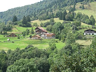
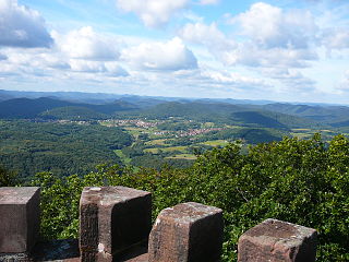
Munster is a commune in the Haut-Rhin department in Grand Est in north-eastern France. It is located in the valley of the river Fecht, in the Vosges mountains about 15 kilometres west of Colmar on the D417 road to the Col de la Schlucht and Épinal.

The Taennchel is one of the summits of the Vosges Mountains, rising to 988 metres (3,241 ft). The Taennchel rises at the East of France, in the département of Haut-Rhin, halfway between Strasbourg to the North and Mulhouse to the South, around 60 km (40 mi) from both cities.

Plainfaing is a commune in the Vosges department in Grand Est in northeastern France.
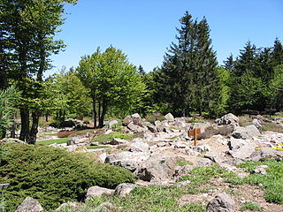
The Jardin d'altitude du Haut Chitelet is a botanical garden specializing in high-elevation alpine plants, located at about 1220 metres elevation on the Route des Crêtes, near the peak of Hohneck (Vosges), about 1 km south of the Col de la Schlucht in Vosges, Lorraine, France. It is maintained by the Jardin botanique du Montet and the Conservatoire et Jardins Botaniques de Nancy, open daily in the warmer months; an admission fee is charged.

Thé Route des Crêtes is an 89 km (55 mi) road in the Vosges Mountains in Eastern France, which passes through the Parc naturel régional des Ballons des Vosges. It connects Sainte-Marie-aux-Mines (north) with Cernay (south) and runs on the border of the departements of Haut-Rhin (68) and Vosges (88). Most of the route is at an elevation in excess of 950 m (3,117 ft), with the highest point being at the Col du Grand Ballon. The road is generally open from April to November, but most of the route is closed in the winter by snow.

The Col de la Schlucht is a mountain pass in the Vosges Mountains of France. On the west side lies the historical region of Lorraine, on the east side lies the historical region of Alsace.
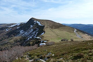
The Hohneck is, at 1,363 m (4,472 ft) the third highest summit of the Vosges Mountains and the highest point of Lorraine. On its summit stands a mountain hut, clearly visible in the distance. Nearby the mountain's top is located the ski resort of La Bresse Hohneck.

The Storkenkopf is the second-highest summit of the Vosges Mountains. It is located in the French region of Alsace, close to the Grand Ballon.

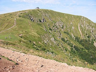
The Battle of Hartmannswillerkopf was a series of engagements during the First World War fought for the control of the Hartmannswillerkopf peak in Alsace in 1914 and 1915. The peak is a pyramidal rocky spur in the Vosges mountains, about 5 km (3.1 mi) north of Thann, standing at 956 m (3,136 ft) and overlooking the Alsace Plain, Rhine valley and the Black Forest in Germany. Hartmanswillerkopf was captured by the French army during the Battle of Mulhouse (7–10, 14–26 August 1914). From the vantage point, Mulhouse and the Mulhouse–Colmar railway could be seen and the French railway from Thann to Cernay and Belfort shielded from German observation.
The Wasgau is a Franco-German hill range in the German state of Rhineland-Palatinate and the French departments of Bas-Rhin and Moselle. It is formed from the southern part of the Palatine Forest and the northern part of the Vosges mountains, and extends from the River Queich in the north over the French border to the Col de Saverne in the south.

At 581 m, the Grand Wintersberg is the highest hill in the North Vosges in Alsace, France.
The Rothenbachkopf is a mountain, 1,315 metres high, in the High Vosges in France. Only a few metres to the west of the summit runs the Route des Crêtes heading south from the Col de la Schlucht. Several Vosges Club hiking trails run over the top. A few kilometres north of the Rothenbachkopfs the border between Alsace and Lorraine turns and heads southwest.

The Gazon du Faing is a granitic summit of the Vosges massif located on the ridge line between the Col du Bonhomme and the Col de la Schlucht.

The Gazon de Faîte refers to a granite summit in the Vosges Mountains located on the ridge line between the Col du Bonhomme and the Col de la Schlucht, south of the Gazon du Faing and north of the Tanet or the Haut-Fourneau.
The Ballon de Servance is a summit in the Southern Vosges Mountains, located on the border of Bourgogne-Franche-Comté and the Grand Est region. It is the highest point in the Haute-Saône department and within the Comtois Balloons National Nature Reserve. It marks the first significant peak with an altitude exceeding 1,000 meters when approaching the Vosges Mountains from the southwest. Its neighbor, the Ballon d'Alsace, only surpasses it by 31 meters.

The Col du Calvaire is a mountain pass in the Vosges Mountains connecting Le Valtin in the Vosges to Orbey in the Haut-Rhin.

The flora of the Vosges massif is distributed across three principal altitudinal zones, namely the collinean, montane, and subalpine levels. The collinean zone extends up to approximately 500 meters in altitude. The montane zone is between 500 and 1,000 meters, with the subalpine zone extending beyond that. The latter's highest point is the Grand Ballon, which reaches 1,424 meters. The diverse environmental conditions, including altitude, climate, topography, and soil types, contribute to the formation of heterogeneous vegetation. The north-south orientation of the mountain range results in a marked contrast between the eastern and western slopes. The western slopes receive abundant precipitation from westerly winds, while the eastern slopes and peaks experience drier conditions.

