Related Research Articles

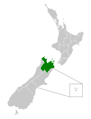
Marlborough District or the Marlborough Region, commonly known simply as Marlborough, is one of the 16 regions of New Zealand, located on the northeast of the South Island. Marlborough is a unitary authority, both a district and a region. Marlborough District Council is based at Blenheim, the largest town. The unitary region has a population of 52,200.

Blenheim is the most populous town in the region of Marlborough, in the north east of the South Island of New Zealand. It has an estimated urban population of 30,500. The surrounding Marlborough wine region is well known as the centre of the New Zealand wine industry. It enjoys one of New Zealand's sunniest climates, with warm, relatively dry summers and cool, crisp winters.
Wye River is a minor river in the northeast of the South Island of New Zealand. It feeds into the Wairau River.
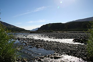
The Wairau River is one of the longest rivers in New Zealand's South Island. It flows for 170 kilometres (110 mi) from the Spenser Mountains, firstly in a northwards direction and then northeast down a long, straight valley in inland Marlborough.

Nelson Province was constituted in 1853 under the New Zealand Constitution Act 1852, and originally covered the entire upper South Island, including all of present-day Buller, Kaikoura, Marlborough, and Tasman districts, along with Nelson City, Grey District north of the Grey River, and the Hurunui District north of the Hurunui River. It was reduced in size by the creation of Marlborough Province in November 1859, then abolished in 1876, along with all the provinces of New Zealand.

The Main North Line, sometimes referred to as part of the South Island Main Trunk railway, is a railway line that runs north from Christchurch in New Zealand up the east coast of the South Island through Kaikōura and Blenheim to Picton. It is a major link in New Zealand's national rail network and offers a connection with roll-on roll-off ferries from Picton to Wellington. It was also the longest railway construction project in New Zealand's history, with the first stages built in the 1870s and not completed until 1945.

The Wairau Bar, or Te Pokohiwi, is a 19-hectare (47-acre) gravel bar formed where the Wairau River meets the sea in Cloudy Bay, Marlborough, north-eastern South Island, New Zealand. It is an important archaeological site, settled by explorers from East Polynesia who arrived in New Zealand about 1280. It is one of the earliest known human settlements in New Zealand. At the time of the occupation it is believed to have been a low scrub-covered island 2 to 3 metres high, 1.1 kilometres (0.68 mi) long and 0.4 kilometres (0.25 mi) wide.

Rangitāne is a Māori iwi (tribe). Their rohe (territory) is in the Manawatū, Horowhenua, Wairarapa and Marlborough areas of New Zealand.
The Wairau Hydro Scheme is a canal based hydroelectric project proposed by TrustPower on the Wairau River in Marlborough, New Zealand. The $280 million project would divert up to 60% of the river through 49 kilometres (30 mi) of canals to generate up to 70 megawatts (94,000 hp) of electricity.
The Ōhinemahuta River, formerly known as the Onamalutu River, is a river of the Marlborough Region of New Zealand's South Island. It initially flows northeast, turning southeast to reach the Wairau River 5 kilometres (3 mi) northwest of Renwick.
The Puhi Puhi River is a river of the Marlborough Region of New Zealand's South Island. It flows southwest, roughly paralleling the Pacific Ocean coast, from its source 12 kilometres (7 mi) west of the mouth of the Waiau Toa / Clarence River, and reaches its outflow into the Hāpuku River 5 kilometres (3 mi) from the latter's mouth at Hapuku. One of the tributaries is the Clinton River.
The Tinline River is a river of the Marlborough Region of New Zealand's South Island. It flows generally south from its sources at the northern end of the Bryant Range to reach the Pelorus River seven kilometres west of Pelorus Bridge. The river is named for John Tinline and commemorates the discovery of a route from Nelson to the Wairau.
The Waikākaho River is a river of the Marlborough Region of New Zealand's South Island. It flows south from its sources southeast of Havelock to reach the Wairau River 5 kilometres (3 mi) west of Tuamarina.
The Wakapuaka River is a river of the Nelson Region of New Zealand's South Island. It flows generally north from its origins in the north of the Bryant Range 14 kilometres (8.7 mi) east of Nelson city centre to reach Delaware Bay, an indentation in the northeast coast of Tasman Bay / Te Tai-o-Aorere.

Joseph Ward was a 19th-century Member of Parliament from Marlborough, New Zealand.
The Waihopai River—the more northerly of two New Zealand rivers of that name—runs through the South Island's Marlborough Region and is a major tributary of the Wairau River. The river has its source in the Raglan Range of mountains, some 70 kilometres (43 mi) northwest of Kaikōura. It runs in a generally northeastward direction for all of its length, the first section of which is through narrow alpine valleys. After joining its major tributary, the Spray River, the valley begins to widen, becoming a broad valley by the time the second main tributary, the Avon River is reached. For the last 15 kilometres (9 mi) of its length the Waihopai turns northward, reaching the Wairau 7 kilometres (4 mi) west of Renwick.
Edith Mary Rudd was a New Zealand civilian and military nurse. She served in both World War I and World War II, and received the Florence Nightingale Medal from the Red Cross in 1961.
The Nelson Marlborough District Health Board was a district health board with the focus on providing healthcare to the Nelson, Tasman and Marlborough districts of New Zealand. In July 2022, it was merged into the national health service Te Whatu Ora.
The Branch River is a river in the Marlborough Region of New Zealand. It is a tributary of the Wairau River, flowing north for 30 kilometres (19 mi) to meet the Wairau 65 kilometres (40 mi) west of the town of Blenheim. Just before flowing into the Wairau, the Branch River crosses underneath State Highway 63.

Tuamarina Cemetery is one of the largest cemeteries in the Marlborough Region of New Zealand. The cemetery predates Omaka Cemetery and has been open to the public for burials since 1866, notwithstanding the burials of twenty two men there in 1843.
References
- ↑ Wellington City Council, Cemetery Records https://wellington.govt.nz/services/community-and-culture/cemeteries/search-cemetery-records/details?id=71562&serviceType=Burial&previousPage=%2fservices%2fcommunity-and-culture%2fcemeteries%2fsearch-cemetery-records%2fresults%3fserviceType%3dAll%26lastName%3dLeatham%26fromDate%3d01%252f01%252f1840%26toDate%3d24%252f09%252f2020%26cemetery%3dAll
- ↑ "Birch Hill Station (Marlborough, N.Z.)".
"Place name detail: Leatham River". New Zealand Gazetteer. New Zealand Geographic Board . Retrieved 12 July 2009.
41°53′13″S173°09′07″E / 41.887°S 173.152°E