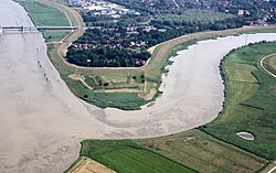
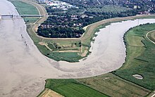
The Weser is a river of Lower Saxony in north-west Germany. It begins at Hannoversch Münden through the confluence of the Werra and Fulda. It passes through the Hanseatic city of Bremen. Its mouth is 50 km (31 mi) further north against the ports of Bremerhaven and Nordenham. The latter is on the Butjadingen Peninsula. It then merges into the North Sea via two highly saline, estuarine mouths.

The Ems is a river in northwestern Germany. It runs through the states of North Rhine-Westphalia and Lower Saxony, and discharges into the Dollart Bay which is part of the Wadden Sea. Its total length is 362.4 kilometres (225.2 mi). The state border between the Lower Saxon area of East Friesland (Germany) and the province of Groningen (Netherlands), whose exact course was the subject of a border dispute between Germany and the Netherlands, runs through the Ems estuary.

The Aller is a 215-kilometre-long (134 mi) river in the states of Saxony-Anhalt and Lower Saxony in Germany. It is a right-hand, and hence eastern, tributary of the Weser and is also its largest tributary. Its last 117 kilometres (73 mi) form the Lower Aller federal waterway (Bundeswasserstraße). The Aller was extensively straightened, widened and, in places, dyked, during the 1960s to provide flood control of the river. In a 20-kilometre-long (12 mi) section near Gifhorn, the river meanders in its natural river bed.

The Leine is a river in Thuringia and Lower Saxony, Germany. It is a left tributary of the Aller and the Weser and it is 281 km (175 mi) long.

The Havel is a river in northeastern Germany, flowing through the states of Mecklenburg-Vorpommern, Brandenburg, Berlin and Saxony-Anhalt. It is a right tributary of the Elbe and 325 kilometres (202 mi) long. However, the direct distance from its source to its mouth is only 94 kilometres (58 mi). For much of its length, the Havel is navigable; it provides an important link in the waterway connections between the east and west of Germany, as well as beyond.
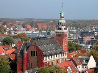
Leer is a town in the district of Leer, the northwestern part of Lower Saxony, Germany. It is situated on the river Leda, a tributary of the river Ems, near the border with the Netherlands. With 34,958 inhabitants (2021), it is the third largest city in East Frisia after Emden and Aurich.

The Lahn is a 245.6-kilometre-long (152.6 mi), right tributary of the Rhine in Germany. Its course passes through the federal states of North Rhine-Westphalia (23.0 km), Hesse (165.6 km), and Rhineland-Palatinate (57.0 km).
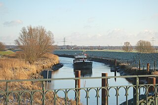
The Lesum is a 9.85-kilometre-long (6 mi) river in northern Germany, right tributary of the Weser, navigable for Class III ships. It is formed at the confluence of the rivers Wümme and Hamme, near Ritterhude, northwest of Bremen. It flows west and flows into the Weser in Bremen-Vegesack.
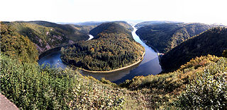
The Saar is a river in northeastern France and western Germany, and a right tributary of the Moselle. It rises in the Vosges mountains on the border of Alsace and Lorraine and flows northwards into the Moselle near Trier. It has two headstreams, that both start near Mont Donon, the highest peak of the northern Vosges. After 246 kilometres (153 mi) the Saar flows into the Moselle at Konz (Rhineland-Palatinate) between Trier and the Luxembourg border. It has a catchment area of 7,431 square kilometres (2,869 sq mi).
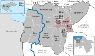
Jümme is a collective municipality (Samtgemeinde) in the district of Leer in the German state of Lower Saxony. It is named after the River Jümme which flows through all three constituent communities. It has an area of 82.34 km² and a population of 6,421. It is situated in the region of East Frisia. Along with the Samtgemeinde of Hesel, it is one of two in the district. It was formed in the wake of local government reform in 1973. Filsum serves as the administrative centre.

Hunte is a 189-kilometre (117 mi) long river in north-western Germany, a left tributary of the Weser.

The Hase is a 169.7-kilometre (105.4 mi) long river of Lower Saxony, Germany. It is a right tributary of the Ems, but part of its flow goes to the Else, that is part of the Weser basin. Its source is in the Teutoburg Forest, south-east of Osnabrück, on the north slope of the 307-metre (1,007 ft) high Hankenüll hill.

Ilmenau is a river south of Hamburg, in Lower Saxony, Germany.
The Stör is a river in Schleswig-Holstein, Germany, right tributary of the Elbe.

Jümme is a river of Lower Saxony, Germany. It is a tributary of the Leda.

The Hümmling is a ground moraine landscape, up to 73 m above sea level (NN), in the Emsland region on the North German Plain in the western part of the German state of Lower Saxony.

The Ochtum is a river in Lower Saxony and Bremen, Germany. Roughly 26 km (16 mi) long, it is a left tributary of the Weser.

The Große Aa is a 35-kilometre-long (22 mi), right, eastern tributary of the River Ems in western Lower Saxony (Germany).
The Schwinge is a river of Lower Saxony, Germany, a left tributary of the Elbe.
The Pinnau is a 41-kilometre-long (25 mi) river, which flows right or northeast of the main river, Elbe. The Pinnau is therefore a tributary in the southern part of Schleswig-Holstein, Germany.