Legislative Assembly of Espírito Santo

Last updated
Legislative Assembly of Espírito Santo
Assembleia Legislativa do Espírito Santo
Brasao do Espirito Santo.svg
Type
Type
Seats 30 deputies
Meeting place
Assembleia Legislativa do Espirito Santo.jpg
Vitória, Espírito Santo
Website
www.al.es.gov.br

The Legislative Assembly of Espírito Santo (Portuguese : Assembleia Legislativa do Espírito Santo) is the unicameral legislature of the state of Espírito Santo in Brazil. It has 30 state deputies elected by proportional representation. It is located in the city of Vitória.
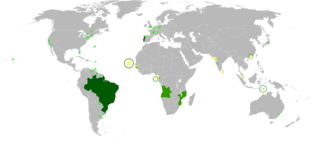
Portuguese language Romance language that originated in Portugal

Portuguese is a Western Romance language originating in the Iberian Peninsula. It is the sole official language of Portugal, Brazil, Cape Verde, Guinea-Bissau, Mozambique, Angola, and São Tomé and Príncipe. It also has co-official language status in East Timor, Equatorial Guinea and Macau in China. As the result of expansion during colonial times, a cultural presence of Portuguese and Portuguese creole speakers are also found in Goa, Daman and Diu in India; in Batticaloa on the east coast of Sri Lanka; in the Indonesian island of Flores; in the Malacca state of Malaysia; and the ABC islands in the Caribbean where Papiamento is spoken, while Cape Verdean Creole is the most widely spoken Portuguese-based Creole. Reintegrationists maintain that Galician is not a separate language, but a dialect of Portuguese. A Portuguese-speaking person or nation is referred to as "Lusophone" (Lusófono).
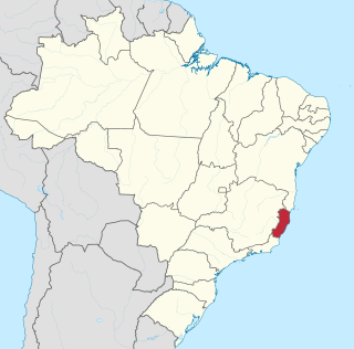
Espírito Santo State of Brazil

Espírito Santo is a state in southeastern Brazil. Its capital is Vitória, and its largest city is the nearby Vila Velha. With an extensive coastline, the state hosts some of the country's main ports, and its beaches are significant tourist attractions.
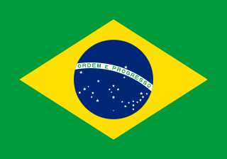
Brazil Federal republic in South America

Brazil, officially the Federative Republic of Brazil, is the largest country in both South America and Latin America. At 8.5 million square kilometers and with over 208 million people, Brazil is the world's fifth-largest country by area and the fifth most populous. Its capital is Brasília, and its most populated city is São Paulo. The federation is composed of the union of the 26 states, the Federal District, and the 5,570 municipalities. It is the largest country to have Portuguese as an official language and the only one in the Americas; it is also one of the most multicultural and ethnically diverse nations, due to over a century of mass immigration from around the world.
Related Research Articles

Vila Velha Municipality in Southeast, Brazil

Vila Velha is a coastal city in Espírito Santo, Brazil. It lies across from Vitória, the state capital. Its population was 396,323 (2005) and its area is 208.82 km².

Rio Novo do Sul is a municipality located in the Brazilian state of Espírito Santo. Its population was 12,065 (2005) and its area is 204 km². The name of this municipality means "New River of the South" in Portuguese.

São Roque do Canaã is a municipality located in the Brazilian state of Espírito Santo. Its population was 10,949 (2005) and its area is 342 km². The capital of the municipality is located at an altitude of 120 meters above sea level.

Vargem Alta is a municipality located in the Brazilian state of Espírito Santo. Its population was 20,066 (2005) and its area is 415 km².

Governador Lindenberg is the name of a Brazilian municipality in the southeastern state of Espírito Santo. Its population was 9,942 (2005) and its area is 360 km².

Estádio Kléber Andrade

Estádio Estadual Kléber José de Andrade, also known as Estádio Kléber Andrade, is a football (soccer) stadium located in Cariacica, Espírito Santo, Brazil. The stadium was built in 1983 and is able to hold 21,152 people.

The Benevente River is a river of Espírito Santo state in eastern Brazil.

The Guarapari River is a river of Espírito Santo state in eastern Brazil.

Iconha River river in Brazil

The Iconha River is a river of Espírito Santo state in eastern Brazil.

The Itapemirim River is a river of Espírito Santo state in eastern Brazil.

The Itapoama River is a river of Espírito Santo state in eastern Brazil.

The Jacaraípe River is a river of Espírito Santo state in eastern Brazil.

The Jucu Braço Norte River is a river of Espírito Santo state in eastern Brazil.

The Jucu Braço Sul River is a river of Espírito Santo state in eastern Brazil.

The Pongal River is a river of Espírito Santo state in eastern Brazil.

The Reis Magos River is a river of Espírito Santo state in eastern Brazil. Its basin, of 700 km2, composes the hydrographic region of the Southeast Atlantic, covering the municipalities of Fundão, Ibiraçu, Santa Leopoldina, Santa Teresa and Serra. It is limited to the north by the Riacho river basin, to the south by the River Santa Maria da Vitoria, to the west by the basin of the Doce River and the east by the Atlantic Ocean.

The Santa Maria da Vitória River is a river of Espírito Santo state in eastern Brazil.

São Mateus River river in Espirito Santo, Brazil

The São Mateus River is a river primarily in Espírito Santo state in eastern Brazil.

Federal University of Espírito Santo Brazilian public university

The Federal University of Espírito Santo is a federal university established at the city of Vitória, capital of Espírito Santo state, in Brazil. It is ranked as the 28th best university in Brazil according to Ranking Universitário Folha (RUF) operated by Folha de S.Paulo and the best university within its own state. In 2018 Ufes was ranked as the 75th best research institution in Ibero-America by the report by SCImago Institutions Ranking.

References

    Coordinates: 20°18′43″S40°17′24″W / 20.3119°S 40.2900°W / -20.3119; -40.2900

    Geographic coordinate system Coordinate system

    A geographic coordinate system is a coordinate system that enables every location on Earth to be specified by a set of numbers, letters or symbols. The coordinates are often chosen such that one of the numbers represents a vertical position and two or three of the numbers represent a horizontal position; alternatively, a geographic position may be expressed in a combined three-dimensional Cartesian vector. A common choice of coordinates is latitude, longitude and elevation. To specify a location on a plane requires a map projection.