
Leigh-on-Sea, commonly referred to simply as Leigh, is a town and civil parish in the city of Southend-on-Sea, in the ceremonial county of Essex, England. In 2011 it had a population of 22,509.

Abberley is a village and civil parish in north west Worcestershire, England.

Admington is a village and civil parish in the Stratford-on-Avon district of the English county of Warwickshire. The name Admington means "estate associated with a man called Æthelhelm" and the village is referred to in the Domesday Book as Edelmintone. Until 31 March 1931 the parish was a part of Gloucestershire. The village lies 1+3⁄4 miles (2.8 km) north-west of Ilmington and 5+1⁄2 miles (8.9 km) north-east of Chipping Campden. The parish has an area of 997 acres (403 ha). Admington shares a village hall with the neighbouring village of Quinton. In the 2001 census the parish had a population of 100. The 2011 census gives population details combined with those of Quinton. Admington is the location of Admington Hall, an early 17th-century country house with an 18th-century façade.
Dodington is a village and civil parish in South Gloucestershire, England. The village lies in a small, fertile valley between Codrington and Old Sodbury, and runs together with the even tinier hamlet of Coombes End. It is about 2.5 miles southeast of Chipping Sodbury and four miles from Yate railway station.
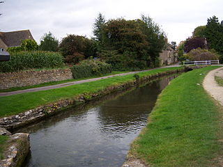
Ashton Keynes is a village and civil parish in north Wiltshire, England which borders with Gloucestershire. The village is about 5 miles (8 km) south of Cirencester and 3.5 miles (5.6 km) west of Cricklade. At the 2011 census the population of the parish, which includes the hamlet of North End, was 1,400.

Cotheridge is a village and civil parish in the district of Malvern Hills in the county of Worcestershire, England. It is 4 miles (6 km) west of the city of Worcester and a mile north-east of the Leigh Court railway station on the Great Western Railway on the opposite side of the River Teme.
The River Teme flows on the southern and south-western part of the village where the land is low-lying and is susceptible to flooding. The soil content is loam and clay with the subsoil being Keuper Marl.
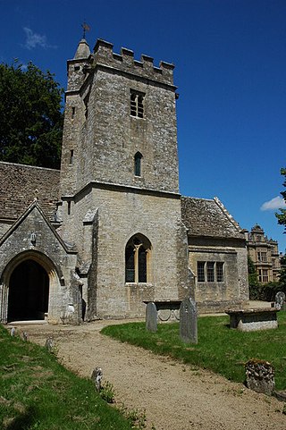
Twyning is a village and civil parish on the River Avon in the north of Gloucestershire, near Tewkesbury, England. The parish is first mentioned in the Liber Wigorniensis in about 1016, where it is called Tuinaeum, part of Gretestane in the county of Winchcombeshire and then mentioned in Domesday Book, described as "Tu(e)ninge, Kings Land : Winchcombe Abbey." The name derives from the Old English for "between the rivers"; despite its spelling, it is pronounced "twinning". The parish forms a land 'isthmus' into the county of Worcestershire.

Nympsfield is a village and civil parish in the English county of Gloucestershire. It is located around four miles south-west of the town of Stroud. As well as Nympsfield village, the parish contains the hamlet of Cockadilly. The population taken at the 2011 census was 382.

Long Marston is a village and civil parish about 5 miles (8 km) southwest of Stratford-upon-Avon in Warwickshire, England. The southern and western boundaries of the parish form part of the county boundary with Worcestershire. The 2011 census recorded the parish's population as 436.

Bransford is a village and civil parish in the Malvern Hills district of the county of Worcestershire, England. It is situated close to the River Teme and the village of Leigh. It is on the primary route between Worcester and Hereford, the A4103 that runs through the centre of the village. According to the 2021 census, Bransford has a population of 527. The parish shares its parish council with Leigh.
Meysey Hampton is a village and civil parish in Gloucestershire, England, approximately 30 miles (48 km) to the south-east of Gloucester. It lies in the south of the Cotswolds, an Area of Outstanding Natural Beauty.

Miserden is a village and civil parish in Stroud District, Gloucestershire, England, 4 miles north east of Stroud. The parish includes Whiteway Colony and the hamlets of Sudgrove and The Camp. In the 2001 census the parish had a population of 420, increasing to 449 at the 2011 census.
Cold Aston is a village and civil parish in Gloucestershire, England, approximately 18 miles (29 km) to the east of Gloucester. It lies in the Cotswolds, an Area of Outstanding Natural Beauty. In the 2011 census, the population was 255.

Leigh is a civil parish in the English county of Staffordshire. The parish includes the village of Church Leigh, together with the settlements of Withington, Upper Leigh, Lower Leigh, Morrilow Heath, Middleton Green, Dodsley, Godstone, Nobut and Field.

Oxenhall is a village and civil parish 10 miles (16 km) north west of Gloucester, in the Forest of Dean district, in the county of Gloucestershire, England. In 2011 the parish had a population of 243. The parish touches Dymock, Gorsley and Kilcot, Kempley, Newent and Upton Bishop. Oxenhall has a parish meeting.
Oxenton is a village and civil parish 11 miles (18 km) north east of Gloucester, in the Tewkesbury district, in the county of Gloucestershire, England. In 2011 the parish had a population of 162. The parish touches Alderton, Ashchurch Rural, Gotherington, Teddington and Stoke Orchard. It is on the west side of Oxenton Hill, a northern outlier of the Cotswolds. Oxenton has a parish meeting.

Pauntley is a village and civil parish in the district of Forest of Dean, Gloucestershire, England. In 2019 it had a population of 304.
Westonbirt with Lasborough is a civil parish in the district of Cotswold, in the county of Gloucestershire, England. It includes the villages of Lasborough and Westonbirt. As of 2019, it has a population of 293.

Sudeley is a civil parish in the district of Tewkesbury, in the county of Gloucestershire, England. The parish includes the village of Charlton Abbots.

