
Beroe Hill is a hill of 400 m in the southwest extremity of Gleaner Heights, Livingston Island, West Antarctica. It is surmounting Perunika Glacier to the south and Saedinenie Snowfield to the northwest. The hill was named after the ancient Thracian town of Beroe, ancestor of the present city of Stara Zagora.

Catalunyan Saddle is a saddle of 1260 m height in the Friesland Ridge of the Tangra Mountains on Livingston Island, in the South Shetland Islands. The saddle is bounded by Lyaskovets Peak to the east and by Presian Ridge to the west. The saddle was named in honour of the Catalans Francesc Sàbat and Jorge Enrique from Juan Carlos I Base who established the first route via the saddle to Mount Friesland on 30 December 1991.

The Debelt Glacier on Varna Peninsula, Livingston Island in the South Shetland Islands, Antarctica is situated southeast of Rose Valley Glacier and northeast of Panega Glacier. It drains the southeastern slopes of Vidin Heights and flows into Moon Bay between Edinburgh Hill and Helis Nunatak. The glacier extends three km in an east-west direction, and 1.5 km in north-south direction.
Kaliakra Glacier is a glacier in northeastern Livingston Island, Antarctica extending 3.8 nautical miles in east-west direction and 4.3 nautical miles in north-south direction, and situated southeast of Saedinenie Snowfield, southwest of Panega Glacier, north of Struma Glacier and upper Huron Glacier, and northeast of Perunika Glacier. It is bounded by Melnik Ridge and Bowles Ridge to the south, by Hemus Peak, Gurev Gap, Gleaner Heights, Elhovo Gap, Leslie Hill, Leslie Gap and Radnevo Peak to the west, and Miziya Peak and Samuel Peak to the north. The glacier drains eastwards into Moon Bay south of Perperek Knoll and north of Sindel Point.
Magura Glacier on the southeast side of Tangra Mountains on Livingston Island in the South Shetland Islands, Antarctica is located to the north of M'Kean Point, northeast of Srebarna Glacier, south of Iskar Glacier and southwest of Dobrudzha Glacier. It is bounded by Great Needle Peak to the west, Vitosha Saddle, Vihren Peak and Helmet Peak to the northwest, Plovdiv Peak and Shishman Peak to the north, and Devin Saddle and Kuber Peak to the northeast. The glacier extends 3.5 km in southwest-northeast direction and 1.9 km in northwest-southeast direction, and flows southeastward into Bransfield Strait.
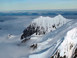
Miziya Peak is the 604 m summit of Vidin Heights on Varna Peninsula, eastern Livingston Island in the South Shetland Islands, Antarctica. The peak overlooks Kaliakra Glacier to the south, and Saedinenie Snowfield to the northwest. First ascent by Lyubomir Ivanov from Camp Academia on 25 December 2004, as part of Tangra 2004/05 survey.

Ongal Peak is a sharp glaciated peak rising to 1151 m on Levski Ridge of Tangra Mountains, Livingston Island in the South Shetland Islands, Antarctica. It surmounts Shipka Valley on the north-northwest, and Huron Glacier and its tributaries on the north and northeast.
Perunika Glacier is an 8 km long and 3 km wide (average) roughly crescent-shaped glacier in eastern Livingston Island in the South Shetland Islands, Antarctica situated east of Pimpirev Glacier, south of Saedinenie Snowfield, southwest of Kaliakra Glacier, west of Huron Glacier, and north of Balkan Snowfield and the head of Huntress Glacier.

Radnevo Peak is a peak of elevation 481 m forming the southwest extremity of Vidin Heights on Varna Peninsula on Livingston Island in the South Shetland Islands, Antarctica. Surmounting Kaliakra Glacier to the southeast and Saedinenie Snowfield to the northwest. Linked to Leslie Hill by Leslie Gap. The peak is named after the town of Radnevo in Southeastern Bulgaria.
Saedinenie Snowfield on Livingston Island in the South Shetland Islands, Antarctica is situated southwest of Rose Valley Glacier, west of Panega Glacier, northwest of Kaliakra Glacier, north of lower Perunika Glacier and east-northeast of Tundzha Glacier. It is bounded by Teres Ridge to the west, the glacial divide between the Drake Passage and Bransfield Strait to the south, Gleaner Heights, Elhovo Gap and Leslie Hill to the southeast, and Leslie Gap and Vidin Heights to the east. The snowfield extends 4.7 km inland and 15.5 km in southwest-northeast direction, and drains into Hero Bay between Melta Point and Slab Point.
Sliven Peak rises to 530 m in the east extremity of Melnik Ridge, Livingston Island in the South Shetland Islands, Antarctica. The peak has precipitous rocky southern slopes and partly ice-free northern slopes, overlooking Kaliakra Glacier to the northwest and Struma Glacier to the south and east.
Struma Glacier is a glacier in eastern Livingston Island in the South Shetland Islands, Antarctica situated south of lower Kaliakra Glacier and north of Huron Glacier. Bounded by Melnik Ridge to the north, Yankov Gap to the west and Bowles Ridge to the south, it is 4.8 km long and 1.5 km wide, and flows eastwards into Moon Bay south of Sindel Point.
Vidin Heights are predominantly ice-covered heights rising to 604 m on Varna Peninsula, eastern Livingston Island in the South Shetland Islands, Antarctica. The feature is approximately 8 km long from the north end of Leslie Gap east-northeastwards to Inott Point and 9.6 km north-northeastwards to Sayer Nunatak. The summit, Miziya Peak, is located 9.25 km north by east of Mount Bowles, 4.24 km north-northeast of Leslie Hill, 9.47 km south of Williams Point and 7.52 km west of Edinburgh Hill. The heights feature also Samuel Peak 1.9 km east-southeast of Miziya Peak, and Sharp Peak at their east-northeast extremity. The heights surmount Saedinenie Snowfield to the northwest, Rose Valley Glacier to the northeast, Debelt Glacier and Panega Glacier to the southeast, and Kaliakra Glacier to the south.

Bowles Ridge is the central ridge of eastern Livingston Island. The ridge extends 6.5 km in the east-west direction and is 1.5 km wide. The summit of the ridge is Mount Bowles which rises to 822m and is located 9.77 km northwest of Great Needle Peak, 6.08 km north by west of Mount Friesland, 8.77 km east-northeast of St. Kliment Ohridski base and 9.25 km south by west of Miziya Peak.

Elemag Reef is the 100 m long in southeast-northwest direction and 40 m wide moraine reef in Moon Bay, Livingston Island in the South Shetland Islands, with a narrow shoal extending for over 400 m eastwards. Surface area 0.33 ha. Situated 5.4 km south-southwest of Edinburgh Hill, 5.95 km west of Half Moon Island, 5.18 km northwest of Rila Point, 3.3 km northeast of Zlatograd Rock and 1.85 km east-southeast of Sindel Point. Formed at the terminus of merging Struma and Huron Glaciers, it was originally named Elemag Point. The current reef configuration is due to glacier retreat of up to 1.8 km in the area in the late 20th and early 21st century. Bulgarian mapping in 2009. Bulgarian topographic survey Tangra 2004/05 and mapping in 2009.
Helmet Peak is a conspicuous peak rising to 1,254 metres (4,114 ft) in Levski Ridge, Tangra Mountains on Livingston Island in the South Shetland Islands, Antarctica just southward of the mouth of Huron Glacier. It is bounded by Devnya Valley to the west, Iskar Glacier to the northeast, and Magura Glacier to the southeast, and has precipitous west and east slopes. It was named by Discovery Investigations personnel during the period 1926–32.
Huntress Glacier is a glacier 7 kilometres (4.3 mi) long and 3.7 kilometres (2.3 mi) wide flowing into the head of False Bay, Livingston Island in the South Shetland Islands, Antarctica. It is situated east of Johnsons Glacier, southeast of Contell Glacier and Balkan Snowfield, south of upper Perunika Glacier, southwest of Huron Glacier and northwest of Macy Glacier, and is bounded by Friesland Ridge and the Tangra Mountains to the southeast, Nesebar Gap, Pliska Ridge, Burdick Ridge and Willan Nunatak to the north, and Charrúa Gap and Napier Peak to the northwest.
The Gleaner Heights are a series of elevations extending for 2 km (1.2 mi) southwest from Leslie Hill in the eastern part of Livingston Island in the South Shetland Islands, Antarctica. They are separated from Leslie Hill by Elhovo Gap, and from Hemus Peak off the northwest extremity of Bowles Ridge by Gurev Gap. The feature is heavily glaciated, with a small rock exposure on its northwest slopes. Gleaner Heights surmount Saedinenie Snowfield to the northwest, Kaliakra Glacier to the east and Perunika Glacier to the southwest. The first ascent was by the Bulgarian Doychin Vasilev from Camp Academia on 25 December 2004, as part of Tangra 2004/05 survey.
Yana Point is the point forming the west side of the entrance to Bruix Cove in eastern Livingston Island in the South Shetland Islands, Antarctica. The point separates the glacier termini of Huron Glacier to the northwest and Iskar Glacier to the southeast. The feature is named after the settlement of Yana in western Bulgaria.
Burdick Peak is the summit of Burdick Ridge rising to 773 m southwest of Mount Bowles on Livingston Island in the South Shetland Islands, Antarctica. It was named by the UK Antarctic Place-names Committee in 1958 for Christopher Burdick, Master of the American schooner Huntress of Nantucket, who visited the South Shetland Islands in 1820–21.


