Lewis Fork Wilderness

Last updated
Lewis Fork Wilderness
2017-05-16 10 31 00 View south along the Appalachian Trail entering the Lewis Fork Wilderness, within the Mount Rogers National Recreation Area in Grayson County, Virginia.jpg
Sign for the wilderness boundary along the Appalachian Trail
USA Virginia relief location map.svg
Red pog.svg
Location Grayson County, Smyth County Virginia, United States
Nearest city Abingdon, Virginia
Coordinates 36°39′35″N81°32′41″W / 36.65972°N 81.54472°W / 36.65972; -81.54472
Area6,076 acres (2,459 ha)
Established1984
Administrator U.S. Forest Service

The Lewis Fork Wilderness is an area in the Mount Rogers National Recreation Area protected by the Eastern Wilderness Act of Congress to maintain its present, natural condition. As part of the wilderness system, it is intended to preserve a variety of natural life forms and contribute to a diversity of plant and animal gene pools. Over half of the ecosystems in the United States exist within designated wilderness. [1]

Contents

The highlight of the wilderness is Mount Rogers, which at 5729 feet is the tallest mountain in Virginia and the highest point in the Appalachians between North Carolina and New Hampshire. With frequent cloud cover and moist moss draping from rocks and tree limbs, the wooded area at the top of the mountain creates a sense of awe in a silence so quiet that a finger snap can produce an echo. [2] [3]

The area is part of the Mount Rogers Cluster .

Location and access

The wilderness is on the southeast side of the Mount Rogers National Recreation Area, near the town of Konnarock in Grayson and Smyth Counties. It is bounded by Whitetop Road (SR 600) on the west, Laurel Valley Road (SR 603) on the north, and Pine Mountain on the southeast. [4] [5]

Boundary of Lewis Fork Wilderness Lewis fork little wilson creek.pdf
Boundary of Lewis Fork Wilderness

The Appalachian Trail passes in an out of the wilderness for a total 5.5 miles in the wilderness. Trailheads are near Elk Garden on the south and Grayson Highlands State Park on the north. [4] [5]

Other Trails in the area include: [5]

Natural history

Mt. Rogers Wild Ponies Mt. Rogers Wild Ponies.jpg
Mt. Rogers Wild Ponies

Habitats created by high elevations, extended slopes and streams support a large biological diversity. The wilderness and surrounding country are considered one of the most important centers for biological diversity in the eastern United States. [3] Besides the oak-hickory forest common in eastern deciduous woodlands, a variety of forest communities include cove forests in rich, moist secluded areas; northern hardwood forests on upper slopes; and seeps, wet places supplied by water from an underground aquifer. [6] [7]

Mount Rogers - Spruce-Fir Forest Mount Rogers - Spruce-Fir Forest.jpg
Mount Rogers - Spruce-Fir Forest

Frazer firs on the summit of Mt. Rogers are beginning to decline because of infestation by the balsam woolly adelgid, an exotic insect pest. [8]

Streams in the area have been recognized for their high water quality. Wild natural trout streams in Virginia are classified by the Department of Game and Inland Fisheries by their water quality, with class i the highest and class iv the lowest. [9] Lewis Fork is a class i stream and Charlies Branch, Daves Branch, Grindstone Branch and Helton Creek are class ii streams. [3]

Grayson Highlands State Park, adjacent to the wilderness, contains balds, large open grassy areas at a high elevation with good views in many directions. Ponies have been introduced into the highlands and allowed to run wild while grazing the balds. [10]

Topography

Mount Rogers is a roundish knob with multiple ridges radiating in all directions. Wilburn Ridge, Cabin Ridge and Briar Ridge are on the south side of Pine Mountain, Elk Ridge is on the north side of Pine Mountain, and Elk Garden Ridge is on the west. Big Laurel Creek, the drainage on the west slope of Elk Ridge, is part of the Holston River watershed; and Lewis Fork, the drainage on the east slope of Elk Ridge, is part of the New River watershed. [3] [10]

The wilderness, in the Southern Blue Ridge Mountains Subsection within the Central Appalachian Broadleaf Coniferous Forest-Meadow Province, has elevations ranging from 3400 feet near Big Laurel Creek to 5700 feet on Mt Rogers. A tectonic uplift of the mountains created the many high gradient streams found in the area. [11] [10]

Management

Designated by Congress in 1984, the wilderness now has a total of 6076 acres, and is managed by the Forest Service through the Mount Rogers National Recreation Area. [4]

There are some regulations to maintain the integrity of the area as a wilderness. For example, motorized equipment, motor vehicles and mountain bikes are prohibited, group size is limited to ten people, and limits are placed on camping. [12]

Nearby Wild Areas

See also

Related Research Articles

<span class="mw-page-title-main">George Washington and Jefferson National Forests</span> Pair of National Forests in the United States

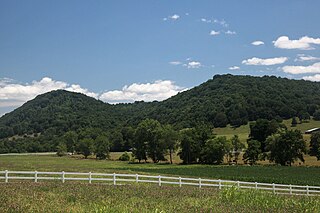
The George Washington and Jefferson National Forests is an administrative entity combining two U.S. National Forests into one of the largest areas of public land in the Eastern United States. The forests cover 1.8 million acres (2,800 sq mi) of land in the Appalachian Mountains of Virginia, West Virginia, and Kentucky. Approximately 1 million acres (1,600 sq mi) of the forest are remote and undeveloped and 139,461 acres (218 sq mi) have been designated as wilderness areas, which prohibits future development.

<span class="mw-page-title-main">Mount Rogers National Recreation Area</span>

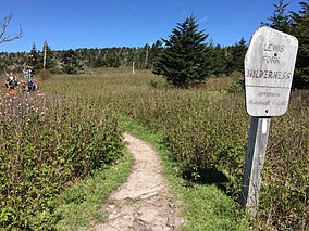
Mount Rogers National Recreation Area is a United States national recreation area (NRA) in southwestern Virginia near the border with Tennessee and North Carolina. It centerpiece is the Lewis Fork Wilderness containing Mount Rogers, the highest point in the state of Virginia with a summit elevation of 5,729 feet. The recreation area is under the jurisdiction of the George Washington and Jefferson National Forests. The recreation area was established by an act of the United States Congress on May 31, 1966.

<span class="mw-page-title-main">Barbours Creek Wilderness</span> Wilderness area in Virginia, United States

Barbours Creek Wilderness is a U.S. wilderness area in the Eastern Divide Ranger District of George Washington and Jefferson National Forests of western Virginia, United States. The wilderness area was established in 1988 and consists of 5,382 acres (2,178 ha) of forests in the Appalachian Mountains ranging in elevation from 1,700 to 3,800 feet.

<span class="mw-page-title-main">Thunder Ridge Wilderness</span> Protected area in Virginia, US

The Thunder Ridge Wilderness is a 2,344 acres (949 ha) area located near Natural Bridge, Virginia, which is protected by the Eastern Wilderness Act of Congress to maintain its present, natural condition. As part of the National Wilderness Preservation System, it helps to preserve a variety of natural life forms and contributes to a diversity of plant and animal gene pools. Over half of the ecosystems in the United States exist within designated wilderness.

<span class="mw-page-title-main">Little Dry Run Wilderness</span> Wilderness area in Virginia, United States

The Little Dry Run Wilderness is an area in the Mount Rogers National Recreation Area protected by the Eastern Wilderness Act of Congress to maintain its present, natural condition. As part of the wilderness system, it is intended to preserve a variety of natural life forms and contribute to a diversity of plant and animal gene pools. Over half of the ecosystems in the United States exist within designated wilderness.

The Raccoon Branch Wilderness is an area in the Mount Rogers National Recreation Area protected by the Eastern Wilderness Act of Congress to maintain its present, natural condition. As part of the wilderness system, it is intended to preserve a variety of natural life forms and contribute to a diversity of plant and animal gene pools. Over half of the ecosystems in the United States exist within designated wilderness.

The Little Wilson Creek Wilderness is an area in the Mount Rogers National Recreation Area protected by the Eastern Wilderness Act of Congress to maintain its present, natural condition. As part of the wilderness system, it is intended to preserve a variety of natural life forms and contribute to a diversity of plant and animal gene pools. Over half of the ecosystems in the United States exist within designated wildernesses.

<span class="mw-page-title-main">White Oak Ridge-Terrapin Mountain</span>

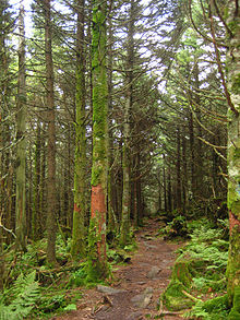
White Oak Ridge-Terrapin Mountain is a wildland in the George Washington and Jefferson National Forests of western Virginia that has been recognized by the Wilderness Society as a special place worthy of protection from logging and road construction. With over 1200 acres of possible old growth forest, this is a rugged area with a rich diversity of geology and plant life.

<span class="mw-page-title-main">North Creek (conservation area)</span>

North Creek (conservation area) is a wildland in the George Washington and Jefferson National Forests of western Virginia that has been recognized by the Wilderness Society as a special place worthy of protection from logging and road construction. Tall evergreen and hardwood trees in the area around Apple Orchard Falls tower above ferns and wildflowers. The area includes a valley which extends from Sunset Fields in the east to its western border near the North Creek Camping Area.

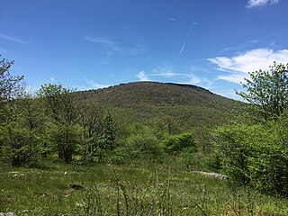
Cove Mountain is a wildland in the George Washington and Jefferson National Forests of western Virginia that has been recognized by the Wilderness Society as a special place worthy of protection from logging and road construction.

Little Dry Run Wilderness Addition is a wildland in the George Washington and Jefferson National Forests of western Virginia that has been recognized by the Wilderness Society as a special place worthy of protection from logging and road construction. The Wilderness Society has designated the area as a "Mountain Treasure".

Shaw Gap is a wildland in the George Washington and Jefferson National Forests of western Virginia that has been recognized by the Wilderness Society as a special place worthy of protection from logging and road construction. The Wilderness Society has designated the area as a "Mountain Treasure".

Feathercamp is a wildland in the George Washington and Jefferson National Forests of western Virginia that has been recognized by the Wilderness Society as a special place worthy of protection from logging and road construction. The Wilderness Society has designated the area as a "Mountain Treasure".

<span class="mw-page-title-main">Mount Rogers Crest Zone</span>

Mount Rogers Crest Zone is a wildland in the George Washington and Jefferson National Forests of western Virginia that has been recognized by the Wilderness Society as a special place worthy of protection from logging and road construction. The Wilderness Society has designated the area as a "Mountain Treasure".

<span class="mw-page-title-main">Whitetop Mountain (conservation area)</span> Protected area in Virginia, USA

Whitetop Mountain (conservation area) is a wildland in the George Washington and Jefferson National Forests of western Virginia that has been recognized by the Wilderness Society as a special place worthy of protection from logging and road construction. The Wilderness Society has designated the area as a "Mountain Treasure".

<span class="mw-page-title-main">Whitetop Laurel</span>

Whitetop Laurel is a wildland in the George Washington and Jefferson National Forests of western Virginia that has been recognized by the Wilderness Society as a special place worthy of protection from logging and road construction. The Wilderness Society has designated the area as a "Mountain Treasure".

Rogers Ridge, a wildland in the George Washington and Jefferson National Forests of western Virginia and the Cherokee National Forest of eastern Tennessee, has been recognized by the Wilderness Society as a special place worthy of protection from logging and road construction. The Wilderness Society has designated the area as a "Mountain Treasure".

London Bridge Branch, a wildland in the George Washington and Jefferson National Forests of western Virginia and the Cherokee National Forest of eastern Tennessee, has been recognized by the Wilderness Society as a special place worthy of protection from logging and road construction. The Wilderness Society has designated the area as a "Mountain Treasure".

Beaverdam Creek (conservation area), a wildland in the George Washington and Jefferson National Forests of western Virginia and the Cherokee National Forest of eastern Tennessee, has been recognized by the Wilderness Society as a special place worthy of protection from logging and road construction. The Wilderness Society has designated the area as a "Mountain Treasure".

<span class="mw-page-title-main">Mount Rogers Cluster</span> Protected natural area in Virginia, United States

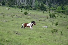
The Mount Rogers Cluster is a region recognized by The Wilderness Society for its unique high elevation mountains, vistas, trout streams and wildlife habitat. The heart of the region is Mount Rogers, the highest mountain in Virginia. The area extends over the Mount Rogers National Recreation Area and into part of the Cherokee National Forest.

References

  1. Wilderness.org: Why Wilderness? | Wilderness.org, accessdate: June 10, 2017
  2. Tennis, Joe (2004). Southwest Virginia Crossroads. Johnson City, Tennessee: Overmountain Press. p. 101. ISBN   1570722560.
  3. 1 2 3 4 Bamford, Sherman (October 2014). 18 Wonders of Virginia. Richmond, Virginia: Sierra Club Virginia Chapter. pp. 63–67. ISBN   978-0-926487-79-6.
  4. 1 2 3 General Information: Wilderness.net - Lewis Fork Wilderness - General Information, accessdate: June 10, 2017
  5. 1 2 3 Mount Rogers High Country. National Geographic Map. ISBN   9781566956642.
  6. Weakley, A. S.; Ludwig, J. C.; Townsend, J. F. (2012). Flora of Virginia. Bland Crowder, ed. Foundation of the Flora of Virginia Project Inc., Richmond. Fort Worth: Botanical Research Institute of Texas Press. p. 80. ISBN   978-1889878-38-6.
  7. Winegar, Deane and Garvey (1998). Highroad Guide to the Virginia Mountains . Marietta, Georgia: Longstreet Press, Inc. pp.  245-246. ISBN   1-56352-462-7.
  8. Horan, Jack (1997). Where Nature Reigns, The Wilderness Areas of the Southern Appalachians. Asheboro, North Carolina: Down Home Press. pp. 175–178. ISBN   1-878086-58-8.
  9. 9VAC25-260-370. Classification Column.: 9VAC25-260-370. Classification Column., accessdate: June 18, 2017
  10. 1 2 3 Virginia Wilderness Committee: Lewis Fork Wilderness - Virginia Wilderness Committee, accessdate: June 10, 2017
  11. Revised Land and Resource Management Plan for the Jefferson National Forest, Management Bulletin R8-MB 115E. Roanoke, Virginia: Jefferson National Forest, US Department of Agriculture. pp. C-90–C-95.
  12. Rules and Regulations: Wilderness.net - Lewis Fork Wilderness - Rules and Regulations, accessdate: June 10, 2017