
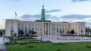
Chingford is a suburban town in east London, England, within the London Borough of Waltham Forest. The centre of Chingford is 9.2 miles (14.8 km) north-east of Charing Cross, with Waltham Abbey to the north, Woodford Green and Buckhurst Hill to the east, Walthamstow to the south, and Edmonton and Enfield to the west. It had a population of 70,583 at the 2021 census.

Leyton is a town in East London, England, within the London Borough of Waltham Forest. It borders Walthamstow to the north, Leytonstone to the east, and Stratford to the south, with Clapton, Hackney Wick and Homerton, across the River Lea, to the west. The area includes New Spitalfields Market, Leyton Orient Football Club, as well as part of the Queen Elizabeth Olympic Park. The town consists largely of terraced houses built between 1870 and 1910, interspersed with some modern housing estates. It is 6.2 miles (10 km) north-east of Charing Cross.

The London Borough of Enfield is a London borough in Greater London, England. The main communities in the borough are Edmonton, Enfield, Southgate and Palmers Green. Enfield is an Outer London borough and forms part of North London, being the northernmost borough and bordering Hertfordshire to the north and Essex to the northeast. The local authority is Enfield London Borough Council, based at Enfield Civic Centre. The borough's population is estimated to be 333,794.
Walthamstow is a town within the London Borough of Waltham Forest in East London. The town borders Chingford to the north, Snaresbrook and South Woodford to the east, Leyton and Leytonstone to the south, and Tottenham to the west. At the 2011 census, Walthamstow had a population of approximately 109,424 and is around 7.5 miles (12 km) north-east of Central London.

The London Borough of Waltham Forest is an outer London borough formed in 1965 from the merger of the municipal boroughs of Leyton, Walthamstow and Chingford.

Leytonstone is an area in East London, England, within the London Borough of Waltham Forest. It adjoins Wanstead to the north-east, Forest Gate to the south-east, Stratford to the south-west, Leyton to the west, and Walthamstow to the north-west, and is 7 miles (11 km) north-east of Charing Cross.

Leyton is a London Underground station in Leyton, in the London Borough of Waltham Forest, East London. Located on Leyton High Road, adjacent to the A12, the station is on the Central line between Stratford and Leytonstone stations. It is in Travelcard zone 3.

Lea Bridge is a district in the London Borough of Hackney and the London Borough of Waltham Forest in London, England. It lies 7 miles (11.3 km) northeast of Charing Cross.

Leyton and Wanstead is a constituency in Greater London created in 1997 and represented in the House of Commons of the UK Parliament since 2024 by Calvin Bailey of the Labour Party.

Chingford and Woodford Green is a constituency in North East London represented in the House of Commons of the UK Parliament by Sir Iain Duncan Smith of the Conservative Party since its creation in 1997.

Walthamstow is a constituency in Greater London created in 1974 and represented in the House of Commons of the UK Parliament since 2010 by Stella Creasy, a member of the Labour and Co-operative Party, in political union with the Labour Party.
Highams Park is a district in the London Borough of Waltham Forest, England, near Epping Forest and 8.1 miles (13 km) north-east of Charing Cross.

Leyton was a local government district in southwest Essex, England, from 1873 to 1965. It included the neighbourhoods of Leyton, Leytonstone and Cann Hall. It was suburban to London, forming part of the London postal district and Metropolitan Police District. It now forms the southernmost part of the London Borough of Waltham Forest in Greater London.
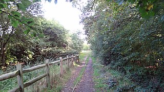
This is a list of Parks and open spaces in the London Borough of Waltham Forest, which contains the most parks of any government district north of the River Thames.

The London Borough of Ealing, one of the outer London boroughs although not on the periphery, has over 100 parks and open spaces within its boundaries. These include allotments, cemeteries, playgrounds, and golf courses in addition to the larger open spaces such as nature conservation areas.

The Lee Valley Ice Centre is located in Leyton in the Lower Lea Valley, London. The original venue opened in 1984, and a major redevelopment and expansion was completed in 2023. The centre now has two Olympic size ice rinks. It is owned by the Lee Valley Regional Park Authority, and is home to the Lee Valley Lions ice hockey team.
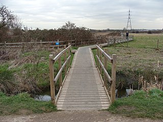
Walthamstow Marshes, is a 36.7-hectare (91-acre) biological Site of Special Scientific Interest in Walthamstow in the London Borough of Waltham Forest. It was once an area of lammas land – common land used for growing crops and grazing cattle.

Green space in central London consists of five of the capital's eight Royal Parks, supplemented by a number of small garden squares scattered throughout the city centre. Open space in the rest of the region is dominated by the remaining three Royal Parks and many other parks and open spaces of a range of sizes, run mainly by the local London boroughs, although other owners include the National Trust and the City of London Corporation.

Leyton Marsh is an open space in the Lower Lea Valley, located in Leyton in the London Borough of Waltham Forest.

Lee Valley Hockey and Tennis Centre is a sports and leisure venue located in Leyton, London Borough of Waltham Forest, to the north of Queen Elizabeth Olympic Park. It is regularly used for international field hockey fixtures by both the Great Britain men's and women's field hockey teams. It hosted the 2018 Women's Hockey World Cup. Owned and managed by Lee Valley Regional Park Authority, the site was previously known as Eton Manor and was a wheelchair tennis venue for the 2012 Summer Paralympics before being converted for public use and reopening in June 2014.

