The New York City Subway is a rapid transit system in the New York City boroughs of Manhattan, Brooklyn, Queens, and the Bronx. It is owned by the government of New York City and leased to the New York City Transit Authority, an affiliate agency of the state-run Metropolitan Transportation Authority (MTA). Opened on October 27, 1904, the New York City Subway is one of the world's oldest public transit systems, one of the most-used, and the one with the most stations, with 472 stations in operation.

St James railway station is a heritage-listed underground commuter rail station that is located on the City Circle, at the northern end of Hyde Park in the Sydney central business district of New South Wales, Australia. It is served by Sydney Trains T2 Inner West & Leppington, T3 Bankstown & T8 Airport & South line services. It is named after the nearby St James' Church. It was added to the New South Wales State Heritage Register on 2 April 1999.

Government Center station is an MBTA subway station in Boston, Massachusetts. It is located at the intersection of Tremont, Court and Cambridge Streets in the Government Center area. It is a transfer point between the light rail Green Line and the rapid transit Blue Line. With the Green Line platform having opened in 1898, the station is the third-oldest operating subway station in the MBTA system; only Park Street and Boylston are older. The station previously served Scollay Square before its demolition for the creation of Boston City Hall Plaza.

Edge Hill railway station is a railway station that serves the district of Edge Hill, Liverpool, England and is one of the oldest railway stations in the world.

The Rochester Industrial and Rapid Transit Railway, more commonly known as the Rochester subway, was a light rail rapid transit line in the city of Rochester, New York that operated from 1927 to 1956. The subway was constructed in the bed of the old Erie Canal, which allowed the route to be grade-separated for its entire length. Two miles (3.2 km) of the route through downtown were constructed in a cut-and-cover tunnel that became Broad Street, and the only underground portion of the subway. The Rochester Subway was designed to reduce interurban traffic on city streets, and to facilitate freight interchange between the railroads. The line was operated on a contract basis by New York State Railways until Rochester Transit Corporation (RTC) took over in 1938. The last day of passenger service was June 30, 1956. Portions of the right-of-way were used for expressway construction, while the rest was abandoned and filled in over the years. The largest remaining section is a stretch of tunnel under Broad Street from Exchange Street to the intersection of Court Street and South Avenue.

The Cincinnati Subway was a partially completed rapid transit system beneath the streets of Cincinnati, Ohio. Although the system only grew to a little over 2 miles (3.2 km) in length, its derelict tunnels and stations make up the largest abandoned subway tunnel system in the United States. Construction began in the early 1900s as an upgrade to the Cincinnati streetcar system, but was abandoned due to escalating costs, the collapse of funding amidst political bickering, and the Great Depression during the 1920s and 1930s.

Graceville railway station is a heritage-listed railway station at 110 Long Street, Graceville, City of Brisbane, Queensland, Australia. It is on the Main line, serving the suburb of Graceville. It was designed by John Sidney Egan and Jan Kral and built from 1958 to 1959 by Railways Department. It was added to the Queensland Heritage Register on 12 June 2009.

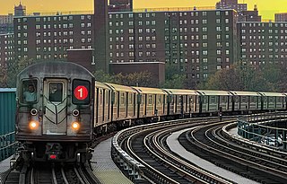
The 191st Street station is a station on the IRT Broadway–Seventh Avenue Line of the New York City Subway. Located at the intersection of St. Nicholas Avenue and 191st Street in the Washington Heights section of Manhattan, it is served by the 1 train at all times. It is the deepest station in the New York City Subway system at about 173 feet (53 m) below street level. Access to the station's main entrance is only provided by four elevators from the mezzanine situated above the platforms. A 1,000-foot-long (300 m) pedestrian tunnel also extends west from the station to Broadway, connecting it with the Fort George neighborhood.

Metro-2 is the informal name for a purported secret underground metro system which parallels the public Moscow Metro. The system was supposedly built, or at least started, during the time of Joseph Stalin and was codenamed D-6 (Д-6) by the KGB. It is supposedly still operated by the Main Directorate of Special Programmes and Ministry of Defence.

Platform screen doors (PSDs), also known as platform edge doors (PEDs), are used at some train, rapid transit and people mover stations to separate the platform from train tracks, as well as on some bus rapid transit, tram and light rail systems. Primarily used for passenger safety, they are a relatively new addition to many metro systems around the world, some having been retrofitted to established systems. They are widely used in newer Asian and European metro systems, and Latin American bus rapid transit systems.

The Jamaica Center–Parsons/Archer station is the northern terminal station of the IND and BMT Archer Avenue Lines of the New York City Subway, located at Parsons Boulevard and Archer Avenue in Jamaica, Queens. It is served by E and J trains at all times, as well as Z trains during rush hours in the peak direction.
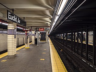
The Euclid Avenue station is an express station on the IND Fulton Street Line of the New York City Subway, located at the intersection of Euclid and Pitkin Avenues in East New York, Brooklyn. It is served by the A train at all times and is the southern terminal for the C train at all times except nights. During nights, this is the northern terminal for the Lefferts Boulevard shuttle train from Ozone Park, Queens.

Lawson railway station is a heritage-listed railway station located on the Main Western line in Lawson in the City of Blue Mountains local government area of New South Wales, Australia. It is also known as Lawson Railway Station Group and Christmas Swamp; Blue Mountain. The property was added to the New South Wales State Heritage Register on 2 April 1999. The station opened on 11 July 1867 as Blue Mountain, being renamed Lawson on 21 April 1879. A passing loop exists north of Platform 1. As part of widening work to the Great Western Highway, a siding south of Platform 2 was removed and a new submerged siding constructed west of the station.

The Second Avenue station is a station on the IND Sixth Avenue Line of the New York City Subway, located at the intersection of Second Avenue and Houston Street on the border between the East Village and the Lower East Side, in Manhattan. It is served by the F train at all times and the <F> train during rush hours in the peak direction.

The Liberty Avenue station is a local station on the IND Fulton Street Line of the New York City Subway, located at the intersection of Liberty and Pennsylvania Avenues in East New York, Brooklyn. It is served by the C train at all times except nights, when the A train takes over service.
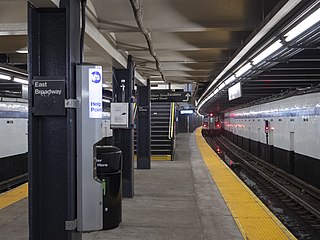
The East Broadway station is a station on the IND Sixth Avenue Line of the New York City Subway. Located at East Broadway and Rutgers Street in the Lower East Side, it is served by the F train at all times and the <F> train during rush hours in the peak direction.

North Philadelphia station is an intercity rail and regional rail station on the Northeast Corridor, located on North Broad Street in the North Philadelphia neighborhood of Philadelphia, Pennsylvania, United States. SEPTA Regional Rail's Trenton Line and Chestnut Hill West Line account for most of the station's service. Three Amtrak trains, two southbound and one northbound, stop on weekdays only.

Westerly station is a passenger rail station on the Northeast Corridor located just north of downtown Westerly, Rhode Island. It is served by Amtrak's Northeast Regional. Amtrak's Acela also passes by this station, but does not stop.

The Tunnel Railway was a 2 ft narrow-gauge underground railway in Ramsgate, Kent, England. Following the restructuring of railway lines in Ramsgate in 1926, the section of line between Broadstairs and Ramsgate Harbour including a tunnel to the seafront at Ramsgate was abandoned. The narrow-gauge Tunnel Railway was opened within the disused tunnel in 1936 to connect tourist attractions and shops near Ramsgate harbour with the new railway main line at Dumpton Park.

The A line is the north-to-south main line of the Frankfurt U-Bahn. It is the oldest and longest line of the U-Bahn system. Served by four routes starting at Südbahnhof Railway Station in Sachsenhausen, the A line runs through downtown Frankfurt up to Heddernheim Station in the north of the city, where it branches out to Ginnheim, Oberursel (U3), Riedberg and Bad Homburg (U2). The U9 service between Ginnheim, Riedberg and Nieder-Eschbach does not use the central section and tunnels of the line, making it the only light rail service of the network that does not serve downtown Frankfurt. The Riedberg and Ginnheim branches were planned as parts of the future D line subway but are operationally part of the A line until the D line development and construction is finished.

