Liberty of Ripon

Last updated

Coordinates: 54°08′20″N1°31′26″W / 54.139°N 1.524°W / 54.139; -1.524 The Liberty of Ripon or Riponshire was a liberty possessing separate county jurisdiction, [1] although situated within the county of Yorkshire, England.

Geographic coordinate system Coordinate system

A geographic coordinate system is a coordinate system that enables every location on Earth to be specified by a set of numbers, letters or symbols. The coordinates are often chosen such that one of the numbers represents a vertical position and two or three of the numbers represent a horizontal position; alternatively, a geographic position may be expressed in a combined three-dimensional Cartesian vector. A common choice of coordinates is latitude, longitude and elevation. To specify a location on a plane requires a map projection.

A liberty was an English unit originating in the Middle Ages, traditionally defined as an area in which regalian right was revoked and where the land was held by a mesne lord. It later became a unit of local government administration.

Yorkshire Historic county of Northern England

Yorkshire, formally known as the County of York, is a historic county of Northern England and the largest in the United Kingdom. Due to its great size in comparison to other English counties, functions have been undertaken over time by its subdivisions, which have also been subject to periodic reform. Throughout these changes, Yorkshire has continued to be recognised as a geographical territory and cultural region. The name is familiar and well understood across the United Kingdom and is in common use in the media and the military, and also features in the titles of current areas of civil administration such as North Yorkshire, South Yorkshire, West Yorkshire and East Riding of Yorkshire.

The liberty was under the jurisdiction of the Archbishop of York, a privilege claimed to have been granted by King Aethelstan in the 10th century. The liberty was governed by a high steward and justices of the peace, appointed by the archbishop, and the area had separate quarter sessions, in conjunction with the mayor and recorder of the borough of Ripon, in whose town hall they were held.

Archbishop of York second most senior bishop of the Church of England

The Archbishop of York is a senior bishop in the Church of England, second only to the Archbishop of Canterbury. The archbishop is the diocesan bishop of the Diocese of York and the metropolitan bishop of the Province of York, which covers the northern regions of England as well as the Isle of Man. The Archbishop of York is an ex officio member of the House of Lords and is styled Primate of England.

Borough An administrative division in some English-speaking countries

A borough is an administrative division in various English-speaking countries. In principle, the term borough designates a self-governing walled town, although in practice, official use of the term varies widely.

Ripon cathedral city in the Borough of Harrogate, North Yorkshire, England

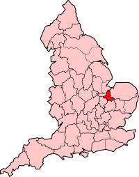
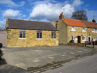
Ripon is a cathedral city in the Borough of Harrogate, North Yorkshire, England. Historically part of the West Riding of Yorkshire, it is located at the confluence of two tributaries of the River Ure, the Laver and Skell. The city is noted for its main feature, Ripon Cathedral which is architecturally significant, as well as the Ripon Racecourse and other features such as its market. The city itself is just over 1,300 years old.

In 1831 the following parishes and townships (locally in the North and West Ridings of Yorkshire) were in the liberty: [2]

North Riding of Yorkshire

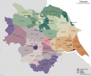
The North Riding of Yorkshire is one of the three historic subdivisions (ridings) of the English county of Yorkshire, alongside the East and West ridings. From the Restoration it was used as a lieutenancy area, having been part of the Yorkshire lieutenancy previously. The three ridings were treated as three counties for many purposes, such as having separate quarter sessions. An administrative county was created with a county council in 1889 under the Local Government Act 1888 on the historic boundaries. In 1974 both the administrative county and the Lieutenancy of the North Riding of Yorkshire were abolished, being succeeded in most of the riding by the new non-metropolitan county of North Yorkshire.

West Riding of Yorkshire one of the historic subdivisions of Yorkshire, England

The West Riding of Yorkshire is one of the three historic subdivisions of Yorkshire, England. From 1889 to 1974 the administrative county, County of York, West Riding, was based closely on the historic boundaries. The lieutenancy at that time included the City of York and as such was named West Riding of the County of York and the County of the City of York.

Felixkirk village in the United Kingdom

Felixkirk is a village and civil parish in the Hambleton District of North Yorkshire, England. The village is situated about three miles north-east of Thirsk. The population of the civil parish was estimated at 100 in 2014.

Sutton-under-Whitestonecliffe village in the United Kingdom

Sutton-under-Whitestonecliffe is a village and civil parish in the Hambleton district of North Yorkshire, England. Historically part of the North Riding of Yorkshire, it is situated on the A170 at the foot of Sutton Bank, about three miles east of Thirsk.

Kilburn, North Yorkshire village in United Kingdom

Kilburn is a village in the civil parish of Kilburn High and Low, in the Hambleton district in the county of North Yorkshire, England. It lies on the edge of the North York Moors National Park, and 6.2 miles (10.0 km) north of Easingwold.

In 1836 the temporal jurisdiction of the archbishop was ended, [3] with the power to appoint justices revested in the crown, and in 1837 the townships locally in the North Riding were removed from the liberty. [4]

In 1889, the Local Government Act 1888 came into operation. Section 48 of the Act merged "every liberty and franchise of a county" into its surrounding administrative county. While this was the end of the liberty's administrative functions, separate quarter sessions continued until 1953, [5] and it was also a distinct unit for land tax purposes for some time.

Local Government Act 1888

The Local Government Act 1888 was an Act of the Parliament of the United Kingdom, which established county councils and county borough councils in England and Wales. It came into effect on 1 April 1889, except for the County of London, which came into existence on 21 March at the request of the London County Council.

An administrative county was an administrative division in England and Wales and Ireland from 1888 to 1974, used for the purposes of local government. They are now abolished, although in Northern Ireland their former areas are used as the basis for lieutenancy.

Related Research Articles

A riding is an administrative jurisdiction or electoral district, particularly in several current or former Commonwealth countries.

Westmorland historic county in England

Westmorland is a historic county in north west England. It formed an administrative county between 1889 and 1974, after which the whole county was administered by the new administrative county of Cumbria. In 2013, the Secretary of State for Communities and Local Government, Eric Pickles, formally recognised and acknowledged the continued existence of England's 39 historic counties, including Westmorland.

Historic counties of England Geographical designations for areas of England, based on historical traditions

The historic counties of England are areas that were established for administration by the Normans, in many cases based on earlier kingdoms and shires created by the Anglo-Saxons and others. They are alternatively known as ancient counties, traditional counties, former counties or simply as counties. In the centuries that followed their establishment, as well as their administrative function, the counties also helped define local culture and identity. This role continued even after the counties ceased to be used for administration after the creation of administrative counties in 1889, which were themselves amended by further local government reforms in the years following.

Cumberland Historic county of England

Cumberland is a historic county of North West England that had an administrative function from the 12th century until 1974. It was bordered by Northumberland to the east, County Durham to the southeast, Westmorland and Lancashire to the south, and the Scottish counties of Dumfriesshire and Roxburghshire to the north. It formed an administrative county from 1889 to 1974 and now forms part of Cumbria.

Isle of Ely former county in England

The Isle of Ely is a historic region around the city of Ely in Cambridgeshire, England. Between 1889 and 1965, it formed an administrative county.

Ceremonial counties of England Collective name for areas, in England, to which a Lord Lieutenant is appointed

The ceremonial counties, also referred to as the lieutenancy areas of England, are areas of England to which a Lord Lieutenant is appointed. Legally the areas in England, as well as in Wales and Scotland, are defined by the Lieutenancies Act 1997 as counties and areas for the purposes of the lieutenancies in Great Britain, in contrast to the areas used for local government. They are also informally known as geographic counties, as often representing more permanent features of English geography, and to distinguish them from counties of England which have a present-day administrative function.

Soke of Peterborough historic area of England

The Soke of Peterborough is an historic area of England associated with the City and Diocese of Peterborough, but considered part of Northamptonshire. The Soke was also described as the Liberty of Peterborough, or Nassaburgh hundred, and comprised, besides Peterborough, about thirty parishes.

The courts of quarter sessions or quarter sessions were local courts traditionally held at four set times each year in the Kingdom of England from 1388 until 1707, then in 18th-century Great Britain, in the later United Kingdom, and in other dominions of the British Empire.

Allertonshire

Allertonshire or Allerton was a wapentake and liberty in the North Riding of Yorkshire, England.

The Ainsty or the Ainsty of York was a historic district of Yorkshire, England west of the city of York. Originally a wapentake or subdivision of the West Riding of Yorkshire it later had a unique status as a rural area controlled by the corporation of the city.

The County Palatine of Durham was an area in the North of England that was controlled by the Bishop of Durham.

A clerk of the peace held an office in England and Wales whose responsibility was the records of the quarter sessions and the framing of presentments and indictments. They had legal training, so that they could advise justices of the peace.

Liberties of the Tower of London former liberty around and including the Tower of London.

The Liberties of the Tower, or the Tower Liberty, was a liberty around and including the Tower of London.

Ripon was a constituency sending members to the House of Commons of the Parliament of the United Kingdom until 1983, centred on the city of Ripon in North Yorkshire.

Local Government (Boundaries) Act 1887

The Local Government (Boundaries) Act 1887 was an Act of the Parliament of the United Kingdom. The Act established boundary commissioners to reform the areas of administrative bodies in England and Wales in preparation for the creation of elected councils by the Local Government Act 1888. In the event, the recommendations of the commissioners were not carried out.

County Hall, Wakefield

County Hall or West Riding County Hall stands at the corner of Bond Street and Cliff Parade in Wakefield, West Yorkshire, England. It is the main headquarters of Wakefield Metropolitan District Council.

The courts of assize, or assizes, were periodic courts held around England and Wales until 1972, when together with the quarter sessions they were abolished by the Courts Act 1971 and replaced by a single permanent Crown Court. The assizes exercised both civil and criminal jurisdiction, though most of their work was on the criminal side. The assizes heard the most serious cases, which were committed to it by the quarter sessions, while the more minor offences were dealt with summarily by justices of the peace in petty sessions.

Liberties Act 1850

The Liberties Act 1850 was an Act of the Parliament of the United Kingdom that provided a mechanism to enable the various liberties or independent jurisdictions in England and Wales to be merged into the geographical counties in which they lay.

References

  1. "Ripon Liberty". Vision of Britain. Retrieved 8 June 2006.
  2. Lewis, Samuel (1831). Topographical Dictionary of England. Vol. III. London.
  3. Liberties Act, 1836 (6 & 7 Will 4 c.87)
  4. "Description of Ripon in 1841" . Retrieved 8 June 2006.
  5. "Ripon Quarter Sessions Courthouse Museum" . Retrieved 8 June 2006.