
Lusatia is a historical region in Central Europe, split between Germany and Poland. Lusatia stretches from the Bóbr and Kwisa rivers in the east to the Pulsnitz and Black Elster rivers in the west, and is located within the German states of Saxony and Brandenburg as well as in the Polish voivodeships of Lower Silesia and Lubusz. Lusatia's central rivers are the Spree and the Lusatian Neisse, which constitutes the border between Germany and Poland since 1945. The Lusatian Mountains, separate Lusatia from Bohemia in the south. Lusatia is traditionally divided into Upper Lusatia and Lower Lusatia.
Elbe-Elster is a Kreis (district) in the southern part of Brandenburg, Germany. Neighboring districts are Teltow-Fläming, Dahme-Spreewald, Oberspreewald-Lausitz, Meißen, Nordsachsen and Wittenberg. The district has a partnership with the Märkischer Kreis.
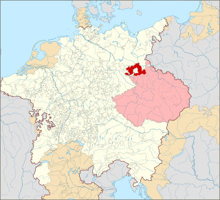
Oberspreewald-Lausitz is a Kreis (district) in the southern part of Brandenburg, Germany. Neighboring districts are Dahme-Spreewald, Spree-Neiße, the districts Bautzen and Meissen in Saxony, and the district Elbe-Elster.

The Bergisches Land is a low mountain range in the state of North Rhine-Westphalia, Germany, east of the Rhine and south of the Ruhr. The landscape is shaped by woods, meadows, rivers and creeks and contains over twenty artificial lakes. Wuppertal is the biggest town, while the southern part has economic and socio-cultural ties to Cologne. Wuppertal and the neighbouring cities of Remscheid and Solingen form the Bergisches Städtedreieck.

Lüneburg Heath is a large area of heath, geest, and woodland in the northeastern part of the state of Lower Saxony in northern Germany. It forms part of the hinterland for the cities of Hamburg, Hanover and Bremen and is named after the town of Lüneburg. Most of the area is a nature reserve. Northern Low Saxon is still widely spoken in the region.
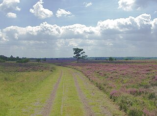
Lower Lusatia is a historical region in Central Europe, stretching from the southeast of the German state of Brandenburg to the southwest of Lubusz Voivodeship in Poland. Like adjacent Upper Lusatia in the south, Lower Lusatia is a settlement area of the West Slavic Sorbs whose endangered Lower Sorbian language is related to Upper Sorbian and Polish.

Bad Liebenwerda is a spa town in the Elbe-Elster district, in southwestern Brandenburg, Germany. It is situated on the river Schwarze Elster, 57 km northwest of Dresden, and 28 km east of Torgau.
Falkenberg is a town in the Elbe-Elster district, in southwestern Brandenburg, Germany. It is situated near the river Schwarze Elster, 16 km east of Torgau, and 13 km northwest of Bad Liebenwerda.
Schwarzheide is a town in the Oberspreewald-Lausitz district, in Lower Lusatia, Brandenburg, Germany. It is situated on the river Schwarze Elster, 11 km southwest of Senftenberg, 110 km south of Berlin and 40 km north of Dresden. The little river Pössnitz runs through the eastern part of Schwarzheide.

The Südheide Nature Park is a large protected area of forest and heathland in the southern part of the Lüneburg Heath in North Germany. It has been designated as a protected nature park since 1964.
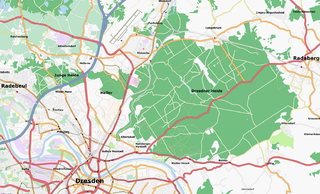
The Dresden Heath is a large forest in the city of Dresden, Germany. The heath is the most important recreation area in the city and is also actively forested. Approximately 6,133 hectares of the Dresden Heath are designated as a nature preserve, making it one of the largest municipal forests in Germany by area. Though mainly agricultural areas border the forest in the east, in all other directions the Dresden Heath is bordered by districts of the city and reaches nearly to the city centre in the southwest.
The Strabrechtse Heide is a natural heathland area about 1500 ha in size, located in the municipalities of Heeze-Leende, Someren and Geldrop-Mierlo, in North Brabant, the Netherlands. It is largely under the care of Staatsbosbeheer. In July 2010, around 200 hectares of the area were damaged or destroyed in a wildfire that took over a week to put out.

Rostock Heath is a wood and heathland region northeast of the German city of Rostock. It has a total area of about 6000 hectares and, since 1252, has been owned by the Hanseatic city of Rostock. As a result of its ownership of the Rostock Heath, Rostock is today one of the five largest communal woodland owners in Germany.

The Düben Heath is a landscape in Germany in eastern Saxony-Anhalt and northern Saxony, between the rivers Elbe and the Mulde, on the northern edge of the Leipzig Bay.

The classification of natural regions of Saxony shown here was produced between 1994 and 2001 by a working group called "Ecosystem and Regional Character" at the Saxonian Academy of Sciences in Leipzig as part of the research and development project "Natural Regions and Natural Region Potential of the Free State of Saxony" at a scale of 1:50,000 as the basis for the rural development and regional planning. This was also supported by the Saxon State Ministry of the Environment and Agriculture and the Saxon Ministry of the Interior.

Wilhelm Hasemann was a German genre painter and illustrator.
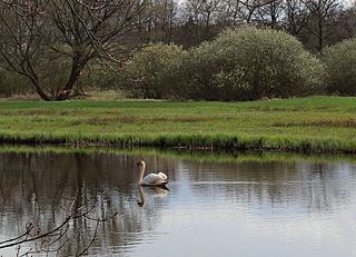
The Alte Röder Nature Reserve lies on the left bank of the Black Elster river between the village of Prieschka in the municipality of Bad Liebenwerda and the village of Würdenhain which belongs to Röderland. It is located within the Lower Lusatian Heath Nature Park, which covers an area of 484 km². The lowland valley of the Röder stream has been protected since 1981 and contains one of the most settled colonies of the Elbe Beaver, a species of beaver threatened by extinction. One of its main conservation aims is the preservation and development of this area as a habitat for the Elbe Beaver and other endangered species.

Elbe-Elster Land, also called the Elbe-Elster region (Elbe-Elster-Gebiet) is a region around the tripoint of the German states of Brandenburg, Saxony-Anhalt and Saxony. It is part of the North German Plain and is named after the two major rivers that have their confluence here: the Elbe and the Black Elster.
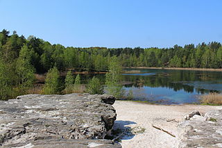
Grube Gotthold is a former brown coal and gravel pit in the South Brandenburg county of Elbe-Elster.
