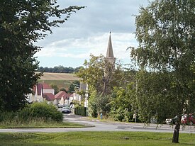
Burgenland is the easternmost and least populous state of Austria. It consists of two statutory cities and seven rural districts, with a total of 171 municipalities. It is 166 km (103 mi) long from north to south but much narrower from west to east. The region is part of the Centrope Project. The name of Burgenland was invented/coined in 1922, after its territories became part of Austria.

Güssing is a town in Burgenland, Austria. It is located at 47°4′N16°19′E, with a population of 3,610 (2023), and is the administrative center of the Güssing district. For centuries the town occupied an important position on the western edge of the Kingdom of Hungary. The town is now most famous for its castle, which is the oldest in Burgenland and a prominent regional landmark, built on an extinct volcano.

Vas is an administrative county of Hungary. It was also one of the counties of the former Kingdom of Hungary. It is part of the Centrope Project.

Bad Tatzmannsdorf is a municipality in Burgenland in the district of Oberwart in Austria.
Bezirk Oberpullendorf is a district of the state of Burgenland in Austria. As of 2023, it had a population of 37,743.

Deutschkreutz is an Austrian market town in the district of Oberpullendorf in the state of Burgenland.

Lackenbach is an Austrian municipality in the District of Oberpullendorf, Burgenland.
Below is a list of Hungarian geographical names in the Burgenland region of Austria.

Stinatz is a town in the district of Güssing in Burgenland in Austria. According to the last census 62% of the population are members of the Burgenland Croat minority.

Lockenhaus is a town in the district of Oberpullendorf in the Austrian state of Burgenland. The town is well known for the annual Lockenhaus Chamber Music Festival founded by violinist Gidon Kremer.

Pilgersdorf is a town in the district of Oberpullendorf in the Austrian state of Burgenland.

Peresznye is a village in Vas County, Hungary, close to the border towards Austria which was drawn in 1921 according to the Treaty of Trianon. It is situated between Lutzmannsburg, Burgenland, Austria, and Csepreg, Hungary, appr. 10 km eastwards of the border town Kőszeg, and inhabited partly by Burgenland Croats.

The Geschriebenstein, less commonly called the Írott-kő in English sources, is a mountain, 884 metres (2,900 ft) high, located on the border between Austria and Hungary. It is the highest mountain of the Kőszeg Mountains, the highest point in western Hungary (Transdanubia) and highest point in the Burgenland. Its height is 884 metres (2,900 ft) according to Austrian sources, whereas Hungarian references mostly mention 883 metres (2,897 ft). The highest point on the Burgenland side of the border is 879 m (AA) (2,884 ft).

Felsőcsatár is a village in Vas County, Hungary.

Burg Lockenhaus is a castle and medieval fortress in the Güns Valley in the southeastern part of Lockenhaus, in Burgenland, eastern Austria. Burg Lockenhaus is 368 metres (1,207 ft) above sea level. The castle was built in Romanesque and Gothic architectural styles around 1200, and was initially called "Leuca" or Léka. It is part of the Naturpark Geschriebenstein.

Rattersdorf is an Austrian hamlet about 90 km south of Vienna, with a population of under 500. It is in the municipality of Mannersdorf an der Rabnitz, Oberpullendorf district, Burgenland state. Until 1899 the village was officially known by the more abbreviated name of Rőt.

Glashütten bei Schlaining is an Austrian dependent hamlet in the federal state of Burgenland. Situated in the municipality of Unterkohlstätten within Oberwart district, the official Hungarian placename until 1899 was Szalonok-Üveghuta.

The Church of Saints Nicholas is an early Baroque parish church located in the Güns Valley in Lockenhaus, in the Austrian state of Burgenland. It was built during the period of 1655 to 1669. Commissioned by Franz III. Nádasdy, the church was entrusted to the Augustinians and was dedicated to both St. Nicholas of Myra and St. Nicholas of Tonentino, in reference to the role of Fr. Nicholas Donellan (O.E.S.A) in Nädasdy's conversion to the Catholic faith. The parish church overlooks the town's main square.

Kőszeg is a district in north-western part of Vas County. Kőszeg is also the name of the town where the district seat is found. The district is located in the Western Transdanubia Statistical Region.

The Sopron–Kőszeg railway line, also known as Burgenlandbahn and Günser Bahn, is a railway line formerly connecting Sopron and Kőszeg, two towns in western Hungary, through the Austrian province Burgenland. It is a single-track partly electrified line, operated by ÖBB and GySEV. Its only connection to the rest of the ÖBB network currently is through Sopron.
This page is based on this
Wikipedia article Text is available under the
CC BY-SA 4.0 license; additional terms may apply.
Images, videos and audio are available under their respective licenses.


