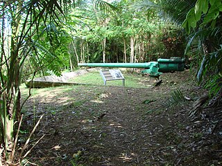
The Piti Guns or Piti Coastal Defense Guns is the site of three Vickers-type Model 3 140-millimetre (5.5 in) coastal defense guns in the War in the Pacific National Historical Park in Piti, Guam. The Japanese manufactured these Model 3 coastal defense guns in 1914. During the Japanese Occupation of Guam from 1941 to 1944, they built up defensive positions on the island. The Chamorro population was forced to work in building up these defenses, and did so here at the Piti Guns.

The Ha. 62-76 Japanese Midget Submarine, is located in front of the T. Stell Newman Visitor Center 1657-B, Santa Rita, Guam, was built in 1944. It is a Type C Kō-hyōteki-class submarine (甲標的丙型) built by Ōurazaki, Kure. It was captured during World War II, after it ran aground on Togcha Beach, near Ipan Talofofo, Guam, in 1944. Its crew surrendered three days later.
The Guam Congress Building, also known as the Guam Legislature Building, is the seat of the Legislature of Guam and is located in Chalan Santo Papa in Hagåtña, Guam. It was built in 1949 by Pacific Island Buildings and of Brown & Root Pacific Bridge & Maxon. It has served as a capitol and as a courthouse building. It is a Modern Movement-style building that was listed on the U.S. National Register of Historic Places in 2007.
The Spanish Dikes, located northeast of Agana Springs, Hagåtña, Guam, are historic 19th-century water control structures that were listed on the National Register of Historic Places in 1974.
The Mesa House, or Dr. Mesa House, is a historic house on Maxwell St. in Hagåtña, Guam.

The Agat Invasion Beach is a historic site in the village of Agat, Guam. The beaches of Agat were one of the landing sites of American forces in the 1944 Battle of Guam, in which the island was retaken from occupying Japanese forces. The designated historic site includes the beaches and inland areas extending between Bangi Point and Togcha Beach. Surviving remnants of the Japanese defenses on this stretch of coast include trenches and rifle pits located a short way inland, and a fortified bunker and 40mm gun emplacements at Ga'an Point. Remnants of pillboxes that had lined the beach also survive, with one at Gangi Point in relatively good condition.

The Agat World War II Amtrac is an underwater relic of World War II, located off Ga'an Point in Agat Bay on the west side of the island of Guam. It is the remains of an LVT 4, an amphibious tracked landing vehicle. It is located about 500 yards (460 m) off Agat Invasion Beach in 45 feet (14 m) of water, and was described as being in good condition when it was discovered and surveyed in 1985. These vehicles were used during the 1944 Battle of Guam, in which American forces recaptured the island from occupying Japanese forces. This particular vehicle does not appear to exhibit significant war damage. This is the most intact of the three Amtracks remaining on Guam from the 850 that participated in the battle. It was re-surveyed by maritime archaeological field schools conducted from 2009 to 2012.
Hill 40 is a militarily historic landform on the island of Guam. It is located about 325 metres (1,066 ft) east of Bangi Point, south of Agat on the island's west coast, rising to a height of 40 to 60 feet above the coastal plain, with a strategically significant view of the Agat Invasion Beach. This hill was the scene of some of the most intense fighting during the landing phase of the 1944 Battle of Guam as Allied forces sought to establish their beachhead against the defending Japanese forces. The American 4th Marine Regiment of the 1st Provisional Marine Brigade captured Hill 40 on June 21, 1944, the day of the landing. That night the Japanese launched a counteroffensive that successfully retook the hill on three occasions. The Marines regrouped and regained the hill each time. The final push came in the early morning hours of July 22. The Japanese 38th Regiment was wiped out during this military action, with 345 killed on the Bangi Point plain, immediately west of Hill 40 near the beach.

The Sumay Cemetery is a historic cemetery at the junction of Sumay Drive and Guam Highway 1 on the grounds of Naval Base Guam, located on the west side of the United States territory of Guam. It is a roughly square cemetery taking up about 0.7 acres (0.28 ha), and is surrounded by a decorative wall with gate. The cemetery was probably established in the late 19th century; its oldest legible marker bears the date 1911. It is the oldest known historic-era cemetery on the island, and is the only tangible reminder of the village of Sumay, which effectively ceased to exist when the naval base took over the area and its citizens were relocated to the village of Santa Rita.
The Unai Obyan Latte Site is a prehistoric archaeological site on the island of Saipan in the Northern Mariana Islands. Located near Obyan Beach on the south coast of the island, it is the site of what was once a fairly extensive village, which was significantly disturbed by Japanese defensive preparations during World War II. The site includes the fragmentary remains of a single latte stone house site and a wide scattering of surface-level remains. Excavation of the latte house site in the 1940s by the pioneering archeologist Alexander Spoehr yielded evidence of a length period of occupation. The village at Obyan was documented in early Spanish accounts of the island, and was probably abandoned when the Spanish forcibly relocated the entire island population to Guam in 1698.

The Asan Invasion Beach is a historic site in the village of Asan, Guam. The beaches of Asan were one of the landing sites of American forces in the 1944 Battle of Guam, in which the island was retaken from occupying Japanese forces. The designated historic site includes the beaches extending between Asan Point and Adelup Point, and extends inland roughly to Guam Highway 1. It also includes the water area extending from the beach to the reef, about 100 metres (330 ft) out, an area that includes at least one abandoned Allied landing vehicle.
The Talagi Pictograph Cave is a rock art site on the island of Guam. It is located on property owned by the government of Guam within the bounds of Andersen Air Force Base on the northern part of the island near Tarague Beach. The cave contains thirteen pictographs representing human figures, and a places where limestone mortar was used that is of prehistoric origin. Based on the characteristics of the figures, it is believed that they were probably the work of a single individual. It is one of a small number known rock art sites on the island.

The Agana-Hagåtña Pillbox is a former Japanese defensive fortification in Hagåtña, Guam. It is a six-sided reinforced concrete structure, located a short way above the high-tide line on the west side of the Paseo de Susana, a small peninsula jutting north from the village center. There is another wall providing cover for the entrance on the land side. The interior is divided into two chambers, each of which has a gun port. The structure was built by Guam's Japanese defenders during their occupation of the island (1941–44) in World War II.

The Dungcas Beach Defense Guns are an old World War II Japanese fortification in the United States territory of Guam. It consists of a tunnel dug in the coral limestone of the cliffs overlooking the beach on the northeast east side of Hagåtña Bay on the west side of the island. The tunnel has two guns mounted at openings facing the beach. This fortification was built by the 48th Independent Mixed Brigade of the 29th Division of the Imperial Japanese Army, during its occupation of the island 1941–44. The guns from this position were probably fired on landing Allied forces during the 1944 Battle of Guam, in which the United States retook the island.
The Faha Massacre Site is located just behind the Pigua cemetery in the village of Merizo on the United States island of Guam. The site is demarcated by four concrete pillars, connected by metal cables, with several crosses placed inside that area. A metal plaque mounted on a concrete block commemorates the thirty native Chamorro men who were slaughtered here on July 16, 1944, by members of the Imperial Japanese Army (IJA) during the Japanese occupation of the island during World War II. The IJA routinely forced Guam's native population to work on its construction projects. The men who were killed here were rounded up for a work crew; why they were killed is unclear, as there were no survivors. The massacre took place one day after the Tinta Massacre, and about one week before the liberation of the island began.
The Mahlac Pictograph Cave is a rock art site on the island of Guam. It is located high in the southern mountains of the island, and contains more than 40 images, rendered in paints that are white, red, brown, and black. The art was carefully analyzed in 2011, and a radiocarbon date of c. 600 CE was obtained from a paint sample. The meaning of the art is a subject of debate.
The Matgue River Valley Battle Area was the site of a decisive Allied victory during the 1944 Battle of Guam. The area was the scene of a major counterattack by Japanese forces against the Allied beachhead, in which the Japanese suffered extremely heavy casualties and were beaten back. After this attack, the remaining Japanese forces on the island retreated to the north. The area is located in the hills southwest of Asan Point along the Matgue River. The only surviving structural remnants associated with the battle are caves dug by the Japanese as defensive positions prior to the invasion.

Gadao's Cave, also known as Liyang Gadao, is a rock art site on the United States island of Guam. Located near the village of Inarajan, the cave is the site of a panel of approximately 50 Chamorro pictographs, painted with a mixture of coral lime and tree sap. The most unusual images are of two human stick figures that appear to be carrying things. It is not known who painted them or when, and what their significance is. The legendary chief of Inarajan Gadao is believed to be the creator of the cave's images.
The Mount Tenjo Fortifications are a historic defensive gun battery site on Mount Tenjo, a hill overlooking Apra Harbor, the principal deep-water port on the island of Guam. The site includes concrete mounting pads for seven guns and the crumbling remains of a concrete command post structure. These facilities are located just below the crest of the hill on its west side. A defensive trench also extends along the top of the plateau-like hill. Unlike most early 20th-century fortifications on Guam, these facilities were built in the late 1910s by the United States Navy, and not by Japanese forces during the World War II occupation period. These are the only known surviving pre-World War II defensive fortification sites on the island. They were functionally abandoned as a result of the 1922 Washington Naval Conference. Mount Tenjo was the site of battle during the 1944 liberation of Guam.

Yokoi's Cave refers to the cave on the island of Guam in which Imperial Japanese Army Sergeant Shoichi Yokoi hid until he was discovered in 1972. Yokoi and several companions hid in the area for more than 25 years, two of them dying in the cave; their remains were found in the cave after Yokoi's surrender. The original cave was destroyed by a typhoon, so a replica was created near the original cave. The replica bears the same name as the original cave, and is a tourist attraction in Talofofo Falls Resort Park in the village of Talofofo.


