Lighthouse of Ponta dos Capelinhos

Last updated
Lighthouse of Ponta dos Capelinhos
Farol dos Capelinhos
Capelinhos Lighthouse (15033904065).jpg
The iconic lighthouse at the tip of Ponta dos Capelinhos and Costa Nau
Lighthouse of Ponta dos Capelinhos
Location Capelo
Horta
Faial
Azores
Portugal
Coordinates 38°35′48.45″N28°49′34.04″W / 38.5967917°N 28.8261222°W / 38.5967917; -28.8261222 Coordinates: 38°35′48.45″N28°49′34.04″W / 38.5967917°N 28.8261222°W / 38.5967917; -28.8261222
Tower
Constructed1894
Constructionstone tower
Height20 metres (66 ft)
Shapeoctagonal tower with balcony and lantern rising from a 2-story keeper's house
Markingsunpainted tower
OperatorCentro de Interpretação do Vulcão dos Capelinhos [1]
Heritageheritage without legal protection  OOjs UI icon edit-ltr-progressive.svg
Light
First lit1903
Deactivated1957 (due to volcano eruption)
Focal height70 metres (230 ft)
Lens500 mm Focal Distance
Intensity1000 W
Characteristic Fl W 7 s

The Lighthouse of Ponta dos Capelinhos (Portuguese : Farol da Ponta dos Capelinhos), or alternately Lighthouse of Capelinhos (Portuguese : Farol dos Capelinhos), is a former beacon/lighthouse located along the coastal peninsula of Ponta dos Capelinhos and Costa Nau, in the civil parish of Capelo, on the island of Faial in the Portuguese archipelago of the Azores. Constructed in the late 19th century, it is an iconic symbol on the island, for the eruption of Capelinhos volcano, which occurred in 1957–58.

Contents

History

The main tower of the lighthouse constructed in volcanic basalt Farol dos Capelinhos 2.jpg
The main tower of the lighthouse constructed in volcanic basalt

Work on the lighthouse began on 18 April 1894, but for many years the necessity of constructing a beacon on the tip of Faial had been advocated by navigators, officials and public opinion, who: " complained to the Government that some lights were need along the islands coast to indicate to navigation that crossed these waters their proximity to land, the loss that [might] occur or the choices to make." [2] The number of incidents in this region reached a grande scale by the end of the 19th century, with more traffic, but records went as far back as 1678. [2]

In the second half of the 19th century, more specifically 1883 and 1884, presentations had been made the Faialense Sociedade de Geografia (Geographic Society of Portugal) and Municipal Council, presided by João José da Graça, to establish two lighthouses on the island (at Capelinhos and Ribeirinha). [2] Still within this decade, Progressive deputy Miguel António da Silveira received authorization that the construction of the first of these lighthouses would be undertaken, but there were no promises or timelines. [2]

What is certain, is that a Lighthouse Commission (Portuguese : Comissão de Faróis) did study the elaboration of an "illumination plan" for the archipelago. [2] But, this commission had gotten bogged-down in the issues of budget, changes in government and lack of political will. In the local newspaper, opinions from the Portuguese marines, José de Almeida de Ávila (brother of the Count of Ávila) and Domingos Tasso de Figuerido were bantered about. [2] These considerations, along with the Lighthouse Commission proposal were presented in May 1892 to the Ministry of Public Works (Portuguese : Ministério das Obras Públicas), and a decision to invest 15 contos de reis was released in April 1894. [2] Elections, on 29 April of the same year, saw Progressive candidates attack the Regenerator plans of José de Almeida de Ávila, stating that "shortly the fiasco of the works on the lighthouse of Capelinhos. [2] After starting the election on 29th day, summer quickly ends the work." Although government candidates were defeated (and José de Almeida de Ávila was forced to resign) the work continued, and the lighthouse eventually inaugurated on 1 August 1903. [2]

The work necessary to begin constructing a lighthouse began on 1 April 1894. [3]

By July 1903 the edifice was in a state of completion. [3]

Capelinhos

Between 1957 and 1958 a volcanic eruption caused the abandon of the lighthouse and the destruction of surrounding buildings Farol dos Capelinhos2.jpg
Between 1957 and 1958 a volcanic eruption caused the abandon of the lighthouse and the destruction of surrounding buildings
The main building and tower were buried by ash and rock to the point that today only the second-floor is visible above ground Acores 2010-07-18 (5036381597).jpg
The main building and tower were buried by ash and rock to the point that today only the second-floor is visible above ground

On 10 October 1957, during a period of repairs by the Directorate for Public Works (Portuguese : Direcção das Obras Públicas), for the district of Horta, under the supervision of the Direcção-Geral dos Edifícios e Monumentos Nacionais (DGEMN) and Direcção dos Serviços de Conservação (Portuguese : Directorate for Conservation Services), the director of the Directorate informed by telegraph the suspension of activities due to the eruption of the Capelinhos volcano. [3]

The first report by directing engineer of Public Works (Frederico de Menezes Avelino Machado) occurred on 7 November 1957, to the director of the DGEMN, over the impact of the eruption on the lighthouse. [3] Included in the report was a unique moment in the contemporary history of the archipelago: [3]

"The eruption at Capelinhos started on 27 September with a small boiling of water at sea some 1 kilometre (0.62 mi) west of the lighthouse. On 29 September, the intensity increased and became highly explosive. The ejecti of ash (sand and powder) reached frequently 800 metres (2,600 ft) and another time reached more than 1,200 metres (3,900 ft). The column of water vapor reached 3 or 4 kilometres (1.9 or 2.5 mi) in height and exceptionally even more. The violence of the eruption continued for a month. The quantity of ash emitted was so great that it formed a small island with 800 metres (2,600 ft) diameter and 100 metres (330 ft) height (above sea level) in an area that where the profundity was 70 metres (230 ft). There fell, near the lighthouse of Capelinhos and Port of Comprido, a few rocks that were about 30 kilograms (66 lb). The cloud was blown by the wind and because of that ash fell some 20 kilometres (12 mi) from the volcanic chimney. This was the aspect more harmful of the eruption. The quantity of ash fell on land dependent on the direction of the wind. When the wind blew strong from the west, on the 6 and 7 October, there was a panic in the settlements of Canto and Norte Pequeno ([civil] parish of Capelo) which lie about 3 kilometres (1.9 mi) from the volcano. The populations were evacuated. In virtue of the dust scattered in the air (which increased greatly the condensation of the water droplets) the rainfall in the region increased by more the twice the normal, passing from 70 millimetres (2.8 in) to more than 700 millimetres (28 in) per month. The torrential rainfall that fell was another disastrous factor in the region. On 29 October the small island became submerged and it appeared that the activity had terminated. But within the following days it continued, it is unclear whether the activity will return and attain the anterior violence...The rocks expelled by the volcano fell on the buildings of the lighthouse of Capelinhos, puncturing the tile and pavements and breaking glass, sanitary wares and some furniture. The lighthouse had to be closed during the eruption and the personnel evacuated. The work that was in course was, therefore, suspended. The ash and rainfall seaped into the holes in the roof and windows and accumulated in almost all the rooms, damaging the interior floors and paintings. The exterior courtyard was, also, littered with more than 1 metre (3.3 ft) of sand." [3] This description was also accompanied by a photographic journal with regists, captions and dated, to illustrate the more important moments of the event between September and November 1957. [3]

Owing to the eruption of the Capelinhos volcano the lighthouse ceased to operate on 29 November 1957. [2] [3]

On 30 April 1958, a new report by Frederico de Menezes Avelino Machado, accompanied by seven photographic entries, in which he described what had occurred since the last report: [3]

"Since the volcanic activity decreased in November and December, the main breakdowns [onsite] were repaired by the Directorate for Lighthouses and in part by the Direcção-Geral dos Edifícios e Monumentos Nacionais, who executed emergency repairs to the tune of 49.611$50 [Portuguese escudo|escudos] to the buildings in order to resist the inclement weather caused by the eruption that persisted for months. In January ashed fell again and (from the Direcção de Obras Públicas) funds were realized (20 contos) to maintain the roofs clean, of which 11.109$00 were spent...In February and March, the eruption had an unexpected development. The crater, that was about 1,200 kilometres (750 mi) from the lighthouse, do farol) shifted to a point 500 metres (1,600 ft) closer, the consequence of the rocks, with weights of between 10–300 kilograms (22–661 lb), and which fell in great abundance, that the roof cleaning work was quickly suspended. Many the rocks damaged the buildings, piercing the fibrocement roof. Ash also fell in great abundance...In one night (23–24 March) a 1.9 metres (6.2 ft) layer of ash fell, corresponding to a load of 2,000 kilograms per cubic metre (120 lb/cu ft). The roofs of the residences fell in and the reinforced concrete slab in the machine building was ruined. There is actually in the lighthouse courtyard ash with a layer of 7 metres (23 ft) approximately and this number continues to increase. It was possible with funds received to remove furniture and machinery (work that was completed by personnel from the lighthouse)...In wake of what has occurred, it appears that no further funds should be spent on the lighthouse until the eruption ends. The tower still maintains itself in reasonable conditions, but the volcanic cone, [now] actually 150 metres (490 ft) is increasing a lot, that maybe we will need to review the future location of the lightouse." [3]

See also

Related Research Articles

<span class="mw-page-title-main">Azores</span> Portuguese archipelago in the North Atlantic Ocean

The Azores, officially the Autonomous Region of the Azores, is one of the two autonomous regions of Portugal. It is an archipelago composed of nine volcanic islands in the Macaronesia region of the North Atlantic Ocean, about 1,400 km (870 mi) west of Lisbon, about 1,500 km (930 mi) northwest of Morocco, and about 1,930 km (1,200 mi) southeast of Newfoundland, Canada.

<span class="mw-page-title-main">Pico Island</span> Portuguese island in Azores archipelago

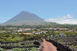
Pico Island is an island in the Central Group of the Portuguese Azores. The landscape features an eponymous volcano, Ponta do Pico, which is the highest mountain in Portugal, the Azores, and the highest elevation of the Mid-Atlantic Ridge. In the tradition of the Portuguese poet, Raul Brandão, Pico is referred to as the Ilha Preta, for its black volcanic soils, which nourish its UNESCO-designated vineyards that once allowed the development of the island's economy. Pico is the second largest and, geologically speaking, the most recently formed island of the Azores, being around 300,000 years old.

<span class="mw-page-title-main">Horta, Azores</span> Municipality in Azores, Portugal

Horta is a municipality and city in the Portuguese archipelago of the Azores encompassing the island of Faial. The population in 2011 was 15,038 in an area of 173.06 square kilometres (66.82 sq mi) The city of Horta itself has a population of about 7,000.

<span class="mw-page-title-main">Faial Island</span> Portuguese island of the Central Group of the Azores

Faial Island, also known in English as Fayal, is a Portuguese island of the Central Group of the Azores.

<span class="mw-page-title-main">Capelinhos</span>

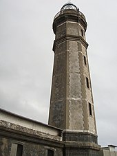
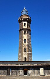
The Capelinhos is a monogenetic volcano located on the western coast of Faial Island in the Azores. It is part of the larger volcanic complex of Capelo, which includes 20 scoria cones and lava fields that are aligned west-northwest to east-southeast from the Caldeira Volcano caldera. Although the name "Capelinhos" is associated with the volcano, it technically refers to the western cape of the parish of Capelo. It can be considered the westernmost point of Europe; there are more westerly islands in the Azores archipelago but they lie on the North American Plate.

<span class="mw-page-title-main">Capelo</span> Civil parish in Azores, Portugal

Capelo is a freguesia in the municipality of Horta on the island of Faial in the Azorean archipelago. The population in 2011 was 486, in an area of 26.64 km². Capelo may be considered the westernmost settlement of Eurasia, if Fajã Grande, on Flores Island, is considered part of North America, for it sits on the North American Plate.

<span class="mw-page-title-main">Cedros (Horta)</span> Civil parish in Azores, Portugal

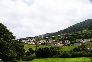
Cedros is a freguesia in the northern part of the municipality of Horta on the island of Faial in the Portuguese archipelago of the Azores. The population in 2011 was 907, in an area of 24.5 square kilometres (264,000,000 sq ft). The northernmost parish on the island, it is located 19 kilometres (12 mi) northwest of Horta and is linked via the Estrada Regional E.R. 1-1ª roadway to the rest of the island. The tree-covered hills and pasture-lands cover the interior, and hedged farmlands extend to the Atlantic coastline cliffs, a natural plateau above the sea, that was settled by early Flemish and Spanish colonists in the late part of the 15th century. Primarily an agricultural community, the population is comparable in size to other parishes on the island, though this has decreased by half since the 1950s. Today, it remains an agricultural centre of the island of Faial, anchored by the Cooperativa Agrícola dos Lactícinios do Faial, one of the primary rural industries on the island, responsible for sales of milk, cheese and butter.

<span class="mw-page-title-main">Praia do Almoxarife</span> Civil parish in Azores, Portugal

Praia do Almoxarife is a freguesia in the municipality (concelho) of Horta, of the Portuguese archipelago of the Azores. The population in 2011 was 834, in an area of 9.20 km². Although it was the beachhead of early settlement on the island, its population has not grown significantly since it was settled. It has become an important summer destination and tourist center for its long black sand beach.

<span class="mw-page-title-main">Ribeirinha (Horta)</span> Civil parish in Azores, Portugal

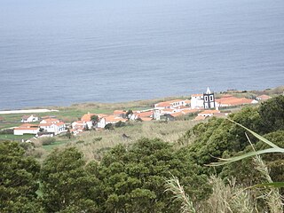
Ribeirinha is a freguesia in the municipality of Horta in the Portuguese archipelago of the Azores. The population in 2011 was 427, in an area of 12.26 km2. It contains the localities Canadinha, Chã da Cruz, Espalhafatos, Lomba dos Espalhafatos and Rua da Igreja.

<span class="mw-page-title-main">Topo Volcanic Complex</span>

Volcanic Complex of Topo is a complex of scoria cones and volcanic structures, located near the village Topo in the southeastern part of the island of São Jorge, in the Portuguese archipelago of the Azores.

<span class="mw-page-title-main">Hydrothermal vents and seamounts of the Azores</span>

The hydrothermal vents and seamounts of the Azores are a series of Atlantic seamounts and hydrothermal vents that are part of the Mid-Atlantic Ridge system, giving rise to the archipelago and bathymetric region of the Azores. These geological structures, formed from masses of basalt, are of a geomorphological interest due to their rich deposits of ore. In addition it fosters a rich ecosystem of diverse subaquatic plant and animal life. There are food chains within this environment, for example, that are purely chemosynthetic, and do not need sunlight for photosynthesis.

<span class="mw-page-title-main">Lighthouse of Ponta da Barca</span> Lighthouse

The Lighthouse of Ponta da Barca is a beacon/lighthouse located along the 24 metres (79 ft) cliffs of Ponta da Barca, near the hamlet of Bom Jesus, civil parish of Santa Cruz da Graciosa on the island of the same, the Portuguese archipelago of the Azores. Immediately near the lighthouse, is the emblematic baleia de pedra, a curious geological basaltic rock that has resisted erosion, in the shape of a whale. The lighthouse includes a symmetrical single-floor building, and a 23-metre (75 ft) high cylindrical tower that extends its lamp to 71 metres (233 ft) above the ocean surface. It is considered a second-order lighthouse, which began operating on 1 February 1930.

<span class="mw-page-title-main">Nature Park of Faial</span> Protected area of the island of Faial

The Nature Park of Faial, or simply Faial Nature Park (PNF), developed from the intention of better managing the protected areas of the island of Faial, and was instituted by the Secretaria Regional do Ambiente e do Mar of the Autonomous Regional Government of the Azores.

<span class="mw-page-title-main">Lighthouse of Ponta das Contendas</span> Lighthouse

The Ponta das Contendas Lighthouse is lighthouse located along the promontory of Contendas, in the civil parish of São Sebastião, municipality of Angra do Heroísmo on the island of Terceira, in the Portuguese archipelago of the Azores.

José de Almeida de Ávila was an official in the Portuguese Marines, obtaining the post of Captain, colonial administrator, Governor of Quelimane and Lourenço Marques, as well as the Civil Governor of the district of Horta.

<span class="mw-page-title-main">Lighthouse of Ponta Garça</span> Lighthouse

The Lighthouse of Ponta Garça is a beacon/lighthouse located along cliffs of the civil parish of Ponta Garça in the municipality of Vila Franca do Campo, in the Portuguese archipelago of the Azores. The lighthouse was built in the 20th century, and consists of a circular tower and rectangular communications block, comparable to other lighthouses in the archipelago, namely Ponte do Cintrão and Ponta do Rosais.

<span class="mw-page-title-main">Lighthouse of Ponta Negra</span> Lighthouse

The Lighthouse of Ponta Negra is a beacon/lighthouse located along the cliffs of promontory of Ponta Negra, in the municipality of Vila do Corvo, on the Portuguese island of Corvo, in the archipelago of the Azores.

<span class="mw-page-title-main">Lighthouse of Vale Formoso</span> Lighthouse

The Lighthouse of Vale Formoso is a beacon/lighthouse located along the southwestern cliffs of the civil parish of Capelo, in the municipality of Horta, on the Portuguese island of Faial, in the archipelago of the Azores.

<span class="mw-page-title-main">Caldeira Volcano</span> Volcano in the Azores, Portugal

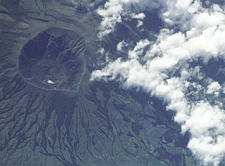
The Caldeira Volcano is the highest mountain, massive stratovolcano and the largest geomorphological structure that forms the island of Faial. The mountain's highest point, Cabeço Gordo, reaches 1,043 metres (3,422 ft) above sea level. One of the most notable features of this volcano is its two kilometer wide caldera, that is 400 m (1,300 ft) in depth below the crater rim.

References

Notes
  1. Rowlett, Russ. "Lighthouses of Portugal: Azores". The Lighthouse Directory. University of North Carolina at Chapel Hill . Retrieved 2016-03-18.
  2. 1 2 3 4 5 6 7 8 9 10 Fernando Faria Ribeiro (2007), p.103
  3. 1 2 3 4 5 6 7 8 9 10 Agarez, Ricardo (2007), SIPA (ed.), Farol da Ponta dos Capelinhos (IPA.00026312/PT072002020034) (in Portuguese), Lisbon, Portugal: SIPA – Sistema de Informação para o Património Arquitectónico, retrieved 7 September 2013
Sources