
Tampere is a city in Pirkanmaa in the western part of Finland. Tampere is the most populous inland city in the Nordic countries; it has a population of 238,140 with the urban area holding 334,112 people and the metropolitan area, also known as the Tampere sub-region, holding 385,301 inhabitants in an area of 4,970 km2 (1,920 sq mi). Tampere is the second-largest urban area and third most-populous individual municipality in Finland, after the cities of Helsinki and Espoo and the most populous Finnish city outside the Greater Helsinki area, within which both Helsinki and Espoo are located. Tampere is a major urban, economic, and cultural hub for central Finland.

The Battle of Tampere was a 1918 Finnish Civil War battle, fought in Tampere, Finland from 15 March to 6 April between the Whites and the Reds. It is the most famous and the heaviest of all the Finnish Civil War battles. Today it is particularly remembered for its bloody aftermath as the Whites executed hundreds of capitulated Reds and took 11,000 prisoners placed in the Kalevankangas camp.

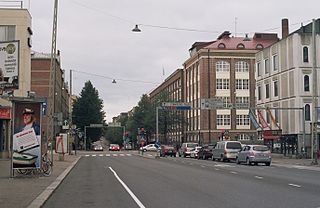
Tampere Central Station is a functionalist building in Tampere, Finland, designed by Eero Seppälä and Otto Flodin, completed in 1936. The 36-metre clock tower was later added because the Finnish railway bureau required it. The city's main street Hämeenkatu begins at the railway station, continuing over the Hämeensilta bridge to its western end at the Aleksanteri church. The Itsenäisyydenkatu street begins at the Tammela side of the station, continuing to the Kaleva Church.

Kaleva Church is an Evangelical Lutheran Church of Finland church in the Liisankallio district of Tampere, Finland. It was designed by Reima and Raili Pietilä and built in 1964-66. The church accommodates approximately 1,120 people. It is considered an example of modern architectural style and is one of the main sights of Tampere.
Tampereen Palloilijat or TaPa is a Finnish football club, based in Tampere. In the past club also played ice hockey, they participated to first ever finnish championship in 1928. In 1931 they won finnish ice hockey championship.
Tammela is a district in Tampere, Finland, located east of the city centre. Tammela was born since the 1870s as a working-class neighbourhood, today it is especially popular among the students of the nearby University of Tampere. Population of Tammela is 5,646.
The city of Tampere, the second largest city and urban area of Finland after Helsinki, can be divided into various sorts of subdivisions. The subdivisions include neighbourhoods, districts, major districts and postal code areas. The plethora of different official ways to divide the city is a source of some confusion to the inhabitants, as different kinds of subdivisions often share similar or identical names.
Hallituskatu is an east–west street running through the districts of Nalkala and Kaakinmaa, in the centre of Tampere, Finland. Its end point in the east is the cartboard factory area of Metsä Board Tako.

Nalkala is a neighbourhood in the city of Tampere, Finland, covering the southern part of the city center from Hämeenkatu to the Laukontori market square. The district is bordered by the lower reaches of Tammerkoski, the Ratina estuary, Lake Pyhäjärvi and to the west by Hämeenpuisto. The original 19th-century street names in the area still include Hämeenkatu, Hallituskatu and Kuninkaankatu, the latter been named after the founder of the city of Tampere, King Gustav III of Sweden. The area is named after two houses called Nalka, which were mentioned in the 1540 land register.

Atala is a neighbourhood in the northeast part of the city of Tampere, Finland, a few kilometers to the east from the border of the Kangasala city. Its neighboring neighborhoods are Holvasti in the south, Linnainmaa in the southwest and Tasanne in the north. The district was named after Ata Oy, which was founded in 1937 and manufactures spiral bevel gears.
Teiskontie is a street and highway in Tampere, Finland. As its name implies, it runs from the center of Tampere towards Teisko, a former municipality connected to Tampere in 1972. To the east of the highway junction of Hervanta, it is part of Highway 12 leading in the direction of Lahti and Kouvola. On the east side of Lake Alasjärvi, Teiskontie has a connection to Highway 9 (E63) leading in the direction of Jyväskylä and Kuopio.

Tampella is a neighbourhood in the northern part of the city center of Tampere, Finland. It consists of the old Tampella factory area, the Armonkallio residential area and the Naistenlahti harbor area. The neighboring parts of the internally heterogeneous district located on the shores of Lake Näsijärvi are Lapinniemi, Lappi, Osmonmäki, Tammela, Jussinkylä, Finlayson and Särkänniemi.
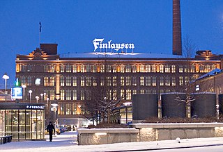
Finlayson is a neighbourhood in the city center of Tampere, Finland, and as the name implies, it consists of the old factory area of Finlayson, as well as Näsinpuisto, the Mustanlahti harbor area and the residential blocks delimited by Hämeenpuisto and Satakunnankatu. To the east, the area borders Tammerkoski. Area attractions include Tallipiha and Finlayson Church. There are also three palace buildings in the district: Finlayson Palace, Näsilinna and Little Palace (Pikkupalatsi). The area starts at Näsilinnankatu and Kuninkaankatu, which extend to Nalkala, and Puuvillatehtaankatu and Näsijärvenkatu, which cross Hämeenpuisto. Neighboring parts of the city are Tammerkoski in the south and Amuri in the west.
Jussinkylä is a neighbourhood in the city center of Tampere, Finland. It is located east of Tammerkoski and borders Satakunnankatu in the south. To the east and northeast, the district is bounded by a railway and to the northwest by Lapintie. The Erkkilä Bridge connects Jussinkylä to Tammela. The most significant landmark in the area is Tampere Cathedral. Neighboring neighborhoods are Finlayson, Tampella and Kyttälä.

Sampo is one of the main districts in the city center of Tampere in Pirkanmaa, Finland. So-called planning area of Sampo includes the statistical areas of Kalevanrinne, Liisankallio, Petsamo, Lappi, Lapinniemi, Kaleva, Järvensivu, Vuohenoja, Kauppi and Kissanmaa.

Kalevanrinne is a district of Tampere, Finland. It is located in the Sampo area between the districts of Kaleva and Järvensivu, bordering Liisankallio and Kalevanharju in the west, Hakametsä and Vuohenoja in the east. The city plan of Kalevanrinne was confirmed in 1951 and supplemented in 1955 and 1960. Kalevanrinne has a hypermarket Prisma, a pet store Musti ja Mirri and a electronics store Gigantti. There are also 13 planned apartment buildings in the area, which means that the Kalevanrinne residential area, located between Kalevantie and Sammonkatu, is planned to have about 1,360 inhabitants. The planned area is about 3,5 hectares in size.

Särkänniemi is a district of the city centre of Tampere, Finland, located on the shores of Lake Näsijärvi, north of the districts of Amuri and Finlayson. The most famous sights of the district are Näsinneula and Särkänniemi Amusement Park, but in addition to that, the district also houses the Haarla's old paper mill building. The Amuri railway stop has also ceased operations in Särkänniemi. The Särkänniemi district also includes the Siilinkari islet in Lake Näsijärvi. Särkänniemi is bordered on the south by Paasikivenkatu, on the other side of which is the Amuri district, and on the west by the Santalahti district. The district includes the Onkiniemi residential area.

Sammonkatu is a wide park street in the Kaleva district in Tampere, Finland. It starts at the intersection of Itsenäisyydenkatu and Teiskontie. The street is part of Kaleva's nationally significant built cultural environment. Along it is, among other things, Sampola, a public building with Sampola Library and Tammerkoski High School.

Osmonmäki is a district in the center of Tampere, Finland. The immediate neighbors of the area are Tammela, Tampella, Lappi and Petsamo. There are apartment buildings in the area, but also hundred-year-old wooden buildings. In 2011, the district had 1,613 inhabitants.

Takahuhti is a district in Tampere, Finland. It is located in eastern part of the city, close to Atala, Linnainmaa, Kissanmaa and Messukylä. There are many prehistoric residences and finds in the area. Takahuhti was the largest village in Messukylä from the Middle Ages to the 20th century. The Battle of Tampere was also fought in Takahuhti during the 1918 civil war. The area is dominated by detached houses and there is a school built in 1939.

