
A wetland is a distinct ecosystem that is flooded by water, either permanently or seasonally, where oxygen-free processes prevail. The primary factor that distinguishes wetlands from other land forms or water bodies is the characteristic vegetation of aquatic plants, adapted to the unique hydric soil. Wetlands play a number of functions, including water purification, water storage, processing of carbon and other nutrients, stabilization of shorelines, and support of plants and animals. Wetlands are also considered the most biologically diverse of all ecosystems, serving as home to a wide range of plant and animal life. Whether any individual wetland performs these functions, and the degree to which it performs them, depends on characteristics of that wetland and the lands and waters near it. Methods for rapidly assessing these functions, wetland ecological health, and general wetland condition have been developed in many regions and have contributed to wetland conservation partly by raising public awareness of the functions and the ecosystem services some wetlands provide.

The Murray–Darling basin is a large geographical area in the interior of southeastern Australia, encompassing the drainage basin of the tributaries of the Murray River, Australia's longest river, and the Darling River, a right tributary of the Murray and Australia's third-longest river. The basin, which includes six of Australia's seven longest rivers and covers around one-seventh of the Australian landmass, is one of the country's most significant agricultural areas. It drains southwestly into the Great Australian Bight and spans most of the states of New South Wales and Victoria, the Australian Capital Territory, and parts of the states of Queensland and South Australia.
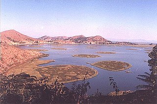
Loktak Lake is the largest freshwater lake in North East India and is famous for the phumdis floating over it. The lake is located at Moirang in Manipur state, India. The etymology of Loktak is Lok = "stream" and tak = "the end". The largest of all the phumdis covers an area of 40 km2 (15 sq mi) and is situated on the southeastern shore of the lake. Located on this phumdi, Keibul Lamjao National Park is the only floating national park in the world. The park is the last natural refuge of the endangered Sangai, Rucervus eldii eldii or Manipur brown-antlered deer, one of three subspecies of Eld's deer.

The Bani River is the principal tributary of the Niger River in Mali. The river is formed from the confluence of the Baoulé and Bagoé rivers some 160 km (99 mi) east of Bamako and it merges with the Niger near Mopti. Its length is about 1,100 km (680 mi).
The Sabarmati river is one of the major west-flowing rivers in India. It originates in the Aravalli Range of the Udaipur District of Rajasthan and meets the Gulf of Khambhat of Arabian Sea after travelling 371 km (231 mi) in a south-westerly direction across Rajasthan and Gujarat. 48 km (30 mi) of the river length is in Rajasthan, while 323 km (201 mi) is in Gujarat.

The Ébrié Lagoon lies in Ivory Coast, separated for almost all of its length from the Atlantic Ocean by a narrow coastal strip. The 130 km (80 mi) long lagoon is linked to the sea by the Vridi Canal, while the Comoë River flows into it. The lagoon averages 4 km in width, and 5 m (16 ft) in depth. Abidjan and towns such as Grand Bassam, Bingerville, Jacqueville, Attécoubé, and Tiagba lie on the lagoon.

The ca. 1000 km long Tana River is the longest river in Kenya, and gives its name to the Tana River County. Its catchment covers ca. 100,000 km² and can be divided into the headwaters and the lower Tana consisting of the section downstream of Kora where the river flows for ca. 700 km through semi-arid plains. Its tributaries include the Thika, as well as several smaller rivers that flow only during the rainy season. The river rises in the Aberdare Mountains to the west of Nyeri. Initially it runs east before turning south around the massif of Mount Kenya. A series of hydroelectric dams has been constructed along the river. These include the Masinga Dam, the Kamburu Dam, the Gitaru Dam, the Kindaruma Dam and the Kiambere Dam .en The Masinga Reservoir and the Kiambere Reservoir, created by the Masinga and Kiambere dams respectively, serve a dual purpose: hydro-electric power (HEP) generation and agricultural irrigation. The other three are used exclusively for HEP generation. A 2003 study reported that two-thirds of Kenya's electrical needs were supplied by the series of dams along the Tana River. Many people believe this river has groundwater underneath it, but it doesn't. The electricity is then supplied to the national grid system and distributed countrywide through a series of substations, transformers and cables.

The Great Ruaha River is a river in south-central Tanzania that flows through the Usangu wetlands and the Ruaha National Park east into the Rufiji River. Its basin catchment area is 83,970 square kilometres (32,421 sq mi). The population of the basin is mainly sustained by irrigation and water-related livelihoods such as fishing and livestock keeping.

Lake Qaraoun is an artificial lake or reservoir located in the southern region of the Beqaa Valley, Lebanon. It was created near Qaraoun village in 1959 by building a 61-metre-high (200 ft) concrete-faced rockfill dam in the middle reaches of the Litani River. The reservoir has been used for hydropower generation, domestic water supply, and for irrigation of 27,500 hectares.
The Kafue Flats are a vast area of swamp, open lagoon and seasonally inundated flood-plain on the Kafue River in the Southern, Central and Lusaka provinces of Zambia. They are a shallow flood plain 240 km long and about 50 km wide, flooded to a depth of less than a meter in the rainy season, and drying out to a clayey black soil in the dry season.

Ujjani Dam, also known as Bhima Dam or Bhima Irrigation Project, on the Bhima River, a tributary of the Krishna River, is an earthfill cum Masonry gravity dam located near Ujjani village of Madha Taluk in Solapur district of the state of Maharashtra in India.

A water footprint shows the extent of water use in relation to consumption by people. The water footprint of an individual, community or business is defined as the total volume of fresh water used to produce the goods and services consumed by the individual or community or produced by the business. Water use is measured in water volume consumed (evaporated) and/or polluted per unit of time. A water footprint can be calculated for any well-defined group of consumers or producers, for a single process or for any product or service.
WEAP is a Windows-based decision support system for integrated water resources management and policy analysis. WEAP is a model-building tool, used to create simulations of water demand, supply, runoff, evapotranspiration, infiltration, crop irrigation requirements, instream flow requirements, ecosystem services, groundwater and surface storage, reservoir operations, and pollution generation, treatment, discharge and instream water quality, all under scenarios of varying policy, hydrology, climate, land use, technology and socio-economic factors. WEAP can dynamically link to the USGS MODFLOW groundwater flow model and the US EPA QUAL2K surface water quality model.

The environmental impacts of irrigation relate to the changes in quantity and quality of soil and water as a result of irrigation and the effects on natural and social conditions in river basins and downstream of an irrigation scheme. The impacts stem from the altered hydrological conditions caused by the installation and operation of the irrigation scheme.
Beles River is a river of western Ethiopia. A tributary of the Abay river, the Beles rises in Dangur woreda to flow in a south-west direction to its confluence. Its catchment area amounts to about 14,200 square kilometers.

The Upper Wardha Dam is an earthfill straight gravity dam across the Wardha River, a tributary of the Godavari River, near Simbhora village in Morshi taluk in Amravati district in the Indian state of Maharashtra. The dam provides multipurpose benefits of irrigation, drinking water supply, flood control and hydropower generation.

The Southern Ewaso Ng'iro is a river in the Great Rift Valley in Kenya. It plays an important role in the ecology of Lake Natron, the main regular breeding site for near-threatened lesser flamingos. Changes to land use in the river's headwaters or in the marshes before the river enters the lake could have a serious impact on this species.
The global freshwater model WaterGAP calculates flows and storages of water on all continents of the globe, taking into account the human influence on the natural freshwater system by water abstractions and dams. It supports understanding the freshwater situation across the world’s river basins during the 20th and the 21st century, and is applied to assess water scarcity, droughts and floods and to quantify the impact of human actions on freshwater. Modelling results of WaterGAP have contributed to international assessment of the global environmental situation including the UN World Water Development Reports, the Millennium Ecosystem Assessment, the UN Global Environmental Outlooks as well as to reports of the Intergovernmental Panel on Climate Change. They were included in the 2012 Environmental Performance Index which ranks countries according to their environmental performance.

Malala-Ambilikala lagoons are two interconnected coastal water-bodies located inside the Bundala National Park, Hambantota District in the Southern Province, Sri Lanka. It is 260 km (160 mi) from Colombo to the arid south. The Malala-Ambilikala lagoons are two of the three key lagoons located within the Bundala Ramsar wetlands.

Noam Weisbrod is an Hydrology Professor at the Department of Environmental Hydrology and Microbiology of the Zuckerberg Institute for Water Research (ZIWR), which is part of the Jacob Blaustein Institutes for Desert Research (BIDR) at Ben-Gurion University of the Negev (BGU). Weisbrod served as director of ZIWR from 2015 to 2018. In 2018 he became director of BIDR.
