Lille, Alberta

Last updated

Lille
French Camp
Lille Alberta Coke Ovens 1.jpg
Ruins of coke ovens at the abandoned Lille townsite
0501 Municipal District Of Ranchland No 66, Alberta, Detailed.svg
Red pog.svg
Lille
0361 Municipality Of Crowsnest Pass, Alberta, Detailed.svg
Red pog.svg
Lille
Alberta County Point Locator.svg
Red pog.svg
Lille
Coordinates: 49°39′04″N114°23′49″W / 49.651°N 114.397°W / 49.651; -114.397
CountryCanada
Province Alberta
Municipal district Ranchland No. 66
Village February 22, 1904 [1]
Dissolved1919 [2]
Government
  Type Unincorporated
  Governing body MD of Ranchland No. 66 Council
Time zone UTC−7 (MST)
  Summer (DST) UTC−6 (MDT)

Lille is a ghost town and former village in the Crowsnest Pass area of southwest Alberta, Canada. It was a company-built coal mining community that, between 1901 and 1912, hosted a population that grew to over 400. The mines at Lille closed in 1912, due primarily to weak coal prices, increasing production costs, and the increasingly poor quality (high ash content) of the coal. The community was then dismantled and most of its structures were moved elsewhere. Today the site is an Alberta Provincial Historic Resource and is known for the elegant ruins of a set of Bernard-style coke ovens that was imported from Belgium. [3]

Contents

History

Population history
of Lille
YearPop.±%
19013    
1906413+13666.7%
1911303−26.6%
19160−100.0%
Source: Statistics Canada [4] [2]

Lille was founded as a coal mining community in 1901 by two representatives of a French company, United Gold Fields Ltd., that was re-established as Western Canadian Collieries in 1903. The company representatives, J. J. Fleutot and C. Remy, were prospecting in the Crowsnest Pass area when they happened upon a coal seam near the future site of Lille. Initially called 'French Camp', [5] the community was renamed Lille after the French town of the same name where the mining venture's financial backers were located. [6] [7] Lille was incorporated as a village on February 22, 1904. [1]

The community was built mostly by the mining company. It had electricity and a water works, and grew to a population of 413 by 1906. [4] It included approximately 80 structures. There were miners' residences, a large residence for the superintendent, a doctor's residence, a 15-bed hospital, a 4-room school house, a post office, and a North-West Mounted Police detachment, as well as a coal washery, the mine stable and corral, and 50 Bernard-style coke ovens. Businesses included a hotel, a general store, a bakery, a butcher shop, barber shops, and a liquor store. [3] [6] [7]

Bituminous coal was produced from seams in the Mist Mountain Formation at three mines near Lille by underground room-and-pillar mining methods. Total production over the community's 11-year history was approximately 901,000 metric tons (993,000 short tons). [7] A rail spur called the Frank and Grassy Mountain Railway was built by the company to transport coal and coke from Lille to the Canadian Pacific Railway mainline at Frank. With a length of 11 kilometres (6.8 mi), the rail spur was an expensive undertaking that required construction of 23 trestle bridges to traverse the rough terrain along the steep, narrow valley of Gold Creek. [6] [7]

The Frank Slide in 1903 was a significant setback for the company. It obliterated the southern portion of the rail spur, including many trestles, and mining operations had to be suspended during the rebuilding. Further, the coke ovens that were originally planned for Frank were set up at Lille instead. The ovens, which were used to convert fine coal (slack) into coke, were imported from Belgium, with each brick numbered for ease of reassembly. [6] [7]

Other setbacks for the company included a forest fire that destroyed the railway trestles, difficulties clearing snow from the rail tracks, labour unrest, weak coal prices, increasing production costs, and the increasingly poor quality (high ash content) of the coal. The mines at Lille closed in 1912, after which most of the buildings and equipment were dismantled and moved elsewhere. [6] [7] By 1916, Lille was no longer populated. [2] The village was dissolved in 1919. [2]

Today

Although Lille was declared an Alberta Provincial Historic Resource in 1978, [3] much of the townsite has fallen prey to scavengers. The main attraction is the elegant ruins of the Belgian coke ovens, and the numbers that were used to reassemble the ovens are still visible on many of the bricks. The site can be reached via a 6.3 km (3.9 mi) hike from a parking area near the Frank Slide Interpretive Centre, [8] or by a 7 km (4.3 mi) hike from a parking area on the Grassy Mountain Road from Blairmore. [7]

See also

Related Research Articles

<span class="mw-page-title-main">Fernie, British Columbia</span> City in British Columbia, Canada

Fernie is a city in the Elk Valley area of the East Kootenay region of southeastern British Columbia, Canada, located on BC Highway 3 on the western approaches to the Crowsnest Pass through the Rocky Mountains. Founded in 1898 and incorporated as the City of Fernie in July 1904, the municipality has a population of over 5,000 with an additional 2,000 outside city limits in communities under the jurisdiction of the Regional District of East Kootenay. A substantial seasonal population swells the city during the winter months.

<span class="mw-page-title-main">Crowsnest Pass</span> Mountain pass in Alberta and British Columbia, Canada

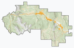
Crowsnest Pass is a low mountain pass across the Continental Divide of the Canadian Rockies on the Alberta–British Columbia border.

<span class="mw-page-title-main">Crowsnest Pass, Alberta</span> Specialized municipality in Alberta, Canada

The Municipality of Crowsnest Pass is a specialized municipality in southwest Alberta, Canada. Within the Rocky Mountains adjacent to the eponymous Crowsnest Pass, the municipality formed as a result of the 1979 amalgamation of five municipalities – the Village of Bellevue, the Town of Blairmore, the Town of Coleman, the Village of Frank, and Improvement District No. 5, which included the Hamlet of Hillcrest and numerous other unincorporated communities.

Frank is an urban community in the Rocky Mountains within the Municipality of Crowsnest Pass in southwest Alberta, Canada. It was formerly incorporated as a village prior to 1979 when it amalgamated with four other municipalities to form Crowsnest Pass.

<span class="mw-page-title-main">Crowsnest River</span> River in Alberta, Canada

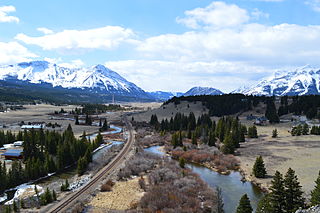
The Crowsnest River is a tributary to the Oldman River in southwestern Alberta, Canada.

<span class="mw-page-title-main">Frank Slide</span> Rockslide, buried part of Frank, Canada (1903)

The Frank Slide was a massive rockslide that buried part of the mining town of Frank in the District of Alberta of the North-West Territories, Canada, at 4:10 a.m. on April 29, 1903. Around 44 million cubic metres/110 million tonnes of limestone rock slid down Turtle Mountain. Witnesses reported that within 100 seconds the rock reached up the opposing hills, obliterating the eastern edge of Frank, the Canadian Pacific Railway (CPR) line and the coal mine. It was one of the largest landslides in Canadian history and remains the deadliest, as between 70 and 90 of the town's residents died, most of whom remain buried in the rubble. Multiple factors led to the slide: Turtle Mountain's formation left it in a constant state of instability. Coal mining operations may have weakened the mountain's internal structure, as did a wet winter and cold snap on the night of the disaster.

Henry L. Frank was an American politician and businessman based in Montana.

<span class="mw-page-title-main">Coleman, Alberta</span> Unincorporated community in Alberta, Canada

Coleman is a community in the Rocky Mountains within the Municipality of Crowsnest Pass in southwest Alberta, Canada. It was formerly incorporated as a town prior to 1979 when it amalgamated with four other municipalities to form Crowsnest Pass.

<span class="mw-page-title-main">Bellevue, Alberta</span> Former village in Alberta, Canada

Bellevue is an urban community perched 4,280 feet elevation in the Rocky Mountains within the Municipality of Crowsnest Pass in southwest Alberta, Canada. It was formerly incorporated as a village prior to 1979 when it amalgamated with four other municipalities to form Crowsnest Pass.

Hillcrest, also known as Hillcrest Mines, is an urban community in the Rocky Mountains within the Municipality of Crowsnest Pass in southwest Alberta, Canada. It was once a hamlet under the jurisdiction of Improvement District (ID) No. 5 prior to 1979 when the former ID No. 5 amalgamated with four other municipalities to form Crowsnest Pass.

<span class="mw-page-title-main">Blairmore, Alberta</span> Former village in Alberta, Canada

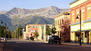
Blairmore is a community in the Rocky Mountains within the Municipality of Crowsnest Pass in southwest Alberta, Canada. It was formerly incorporated as a town prior to 1979 when it amalgamated with four other municipalities to form Crowsnest Pass. Blairmore is the principal commercial centre of Crowsnest Pass.

<span class="mw-page-title-main">Nordegg</span> Hamlet in Alberta, Canada

Nordegg is a hamlet in west-central Alberta, Canada within Clearwater County. It is in the North Saskatchewan River valley in the foothills of the Canadian Rockies, just east of the intersection of the David Thompson Highway and the Highway 734 spur of the Bighorn Highway. A former coal mining town, it was named after Martin Nordegg and the name probably means "North Corner" in a German dialect. The railway station name at the locality was called Brazeau rather than Nordegg at certain points in its history, but the local post office has always been named Nordegg. The name Brazeau is now obsolete.

Luscar is a ghost town in west-central Alberta, Canada that was once a coal mining community. It was in the foothills of the Northern Rockies about 12 kilometres (7.5 mi) northwest of Cadomin along the Bighorn Highway, at the end of the CN Railway line.

Coalspur is a nearly abandoned coal-mining and railroad town in Yellowhead County, Alberta. It is situated on Highway 47 beside the Embarras River in the foothills of the Canadian Rockies.

<span class="mw-page-title-main">Dunlap coke ovens</span> United States historic place

The Dunlap coke ovens are the remnants of a coke production facility near Dunlap, in the U.S. state of Tennessee. Built in the early 1900s, the facility consists of five batteries of 268 beehive ovens, which operated under various companies until the early 1920s. The ovens are now listed on the National Register of Historic Places, and are maintained by the Sequatchie Valley Historical Society as part of Dunlap Coke Ovens Park.

The Mist Mountain Formation is a geologic formation of latest Jurassic to earliest Cretaceous age in the Western Canada Sedimentary Basin that is present in the southern and central Canadian Rockies. It was named for outcrops along the western spur of Mist Mountain in Alberta by D.W. Gibson in 1979. The Mist Mountain Formation contains economically important coal seams that have been mined in southeastern British Columbia and southwestern Alberta.

The Greenhill Mine was a coal mine north of Blairmore, Alberta, Canada.

Coal in Alberta is found in the Coalspur Formation in the Western Canada Sedimentary Basin in the foothills of southwestern Alberta. The Coalspur Formation, which has large quantities of high-quality coal, runs from south of the Wapiti River to the North Saskatchewan River. The Coalspur coal zone is about 120 metres (390 ft) to 200 metres (660 ft) thick.

Passburg is a ghost town in the Municipality of Crowsnest Pass in southern Alberta, Canada that was formerly a coal mining community. It is on Highway 3 approximately 130 km (81 mi) west of Lethbridge and 4 km (2.5 mi) southeast of Bellevue.

The Grassy Mountain Coal Project was a proposed open-pit mine to produce metallurgical coal, initially submitted to the Alberta Energy Regulator by the Australian-based Benga Mining in 2015. The proposed mine was located on a previously abandoned mine site near Crowsnest Pass, Alberta, Canada in the eastern slopes of the Rocky Mountains. In their June 17, 2021 final report, the joint provincial-federal review panel composed of the Alberta Energy Regulator (AER) and the Minister of Environment and Climate Change Canada (ECCC) denied Benga Mining's application for the Grassy Mountain Coal Project because of significant adverse environmental effects.

References

  1. 1 2 North-West Territories Gazette. Government of the North-West Territories. March 15, 1904. p. 13.
  2. 1 2 3 4 "Table 6: Population by census subdivisions, 1901–1961". 1961 Census of Canada (PDF). Series 1.1: Historical, 1901–1961. Vol. I: Population. Ottawa: Dominion Bureau of Statistics. March 8, 1963. pp. 6.77–6.83. Retrieved October 24, 2021.
  3. 1 2 3 "Village of Lille". Canada's Historic Places. Government of Canada. Retrieved September 24, 2018.
  4. 1 2 "Table 1: Population by sexes in 1906 and 1901". 1906 Census: Northwest Provinces (Manitoba Saskatchewan Alberta) (PDF). Vol. I: Population of 1906 Compared with 1901. Ottawa: Dominion Bureau of Statistics. 1907. pp. 55–78. Retrieved October 24, 2021.
  5. Crowsnest Pass Historical Society (1979). Crowsnest and its people. Coleman: Crowsnest Pass Historical Society. p. 121. ISBN   0-88925-046-4.
  6. 1 2 3 4 5 Meaghan Porter (March 2006). Historical Archaeology at an Industrial Town Site: Lille, Alberta (PDF) (M.A. thesis). University of Saskatchewan. p. 12
  7. 1 2 3 4 5 6 7 Jane Ross, and William Tracey, 1996. Hiking the historic Crowsnest Pass. Rocky Mountain Books, Calgary, Alberta, 160 p. ISBN   0-921102-01-1
  8. Joey Ambrosi,1999. Hiking the southern Rockies. Friends of the Frank Slide Centre Society, Blairmore, Alberta, 310 p. ISBN   0-9685670-0-2

Commons-logo.svg Media related to Lille, Alberta at Wikimedia Commons