Harnett County is a county located in the U.S. state of North Carolina. As of the 2010 census, the population was 114,678. Its county seat is Lillington, and its largest city is Dunn.
Dunn is a city in Harnett County, North Carolina, United States. The population was 9,263 at the 2010 census, and an estimated 9,873 in 2016. It is the anchor city of the Dunn Micropolitan Area, population 114,678, which is a part of the greater Raleigh–Durham–Cary Combined Statistical Area (CSA) as defined by the United States Census Bureau.
The Research Triangle, commonly referred to as simply The Triangle, is a region in the Piedmont of North Carolina in the United States, anchored by the three major research universities of North Carolina State University, Duke University, and University of North Carolina at Chapel Hill, as well as the cities of Raleigh and Durham and the town of Chapel Hill. The eight-county region, officially named the Raleigh–Durham–Chapel Hill combined statistical area (CSA), comprises the Raleigh and Durham–Chapel Hill metropolitan areas and the Dunn, Henderson, Oxford, and Sanford Micropolitan Statistical Areas.
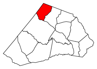
Geographically, Lillington Township occupies 28.76 square miles (74.5km2) in central Harnett County. The only incorporated municipality within Lillington Township is the Town of Lillington, the county seat of Harnett County. However, there are several other unincorporated communities located in Lillington Township, including Harnett and Shawtown.
Lillington is a town in Harnett County, North Carolina, United States. The population was 3,194 at the 2010 census, and was estimated in 2016 to be 3,581. It is the county seat of Harnett County. Lillington is a part of the Dunn Micropolitan Area, which is also a part of the greater Raleigh–Durham–Cary Combined Statistical Area (CSA) as defined by the United States Census Bureau.
A county seat is an administrative center, seat of government, or capital city of a county or civil parish. The term is used in Canada, China, Romania, Taiwan and the United States. County towns have a similar function in the United Kingdom and Republic of Ireland, and historically in Jamaica.
Harnett is an unincorporated community located along U.S. Highway 401 in the southern part of Lillington Township in Harnett County, North Carolina between Lillington and Bunnlevel. It is a part of the Dunn Micropolitan Area, which is also a part of the greater Raleigh–Durham–Cary Combined Statistical Area (CSA) as defined by the United States Census Bureau.
A geographic coordinate system is a coordinate system that enables every location on Earth to be specified by a set of numbers, letters or symbols. The coordinates are often chosen such that one of the numbers represents a vertical position and two or three of the numbers represent a horizontal position; alternatively, a geographic position may be expressed in a combined three-dimensional Cartesian vector. A common choice of coordinates is latitude, longitude and elevation. To specify a location on a plane requires a map projection.
This page is based on this Wikipedia article Text is available under the CC BY-SA 4.0 license; additional terms may apply. Images, videos and audio are available under their respective licenses.
Related Research Articles
Turlington is an unincorporated community in eastern Harnett County, North Carolina between the towns of Coats and Erwin, North Carolina. It is a part of the Dunn Micropolitan Area, which is also a part of the greater Raleigh–Durham–Cary Combined Statistical Area (CSA) as defined by the United States Census Bureau.
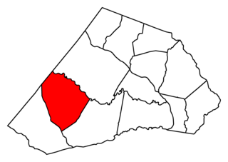
Neills Creek Township is one of thirteen townships in Harnett County, North Carolina, United States. The township had a population of 5,921 according to the 2000 census. It is a part of the Dunn Micropolitan Area, which is also a part of the greater Raleigh–Durham–Cary Combined Statistical Area (CSA) as defined by the United States Census Bureau.
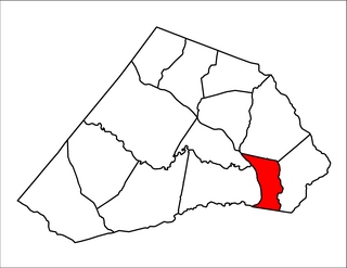
Black River Township is one of thirteen townships in Harnett County, North Carolina, United States. The township had a population of 8,085 according to the 2000 census. It is a part of the Dunn Micropolitan Area, which is also a part of the greater Raleigh–Durham–Cary Combined Statistical Area (CSA) as defined by the United States Census Bureau.
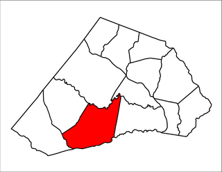
Averasboro Township is one of thirteen townships in Harnett County, North Carolina, United States. The township had a population of 12,965 according to the 2000 census and is the largest township in Harnett County by population. It is a part of the Dunn Micropolitan Area, which is also a part of the greater Raleigh–Durham–Cary Combined Statistical Area (CSA) as defined by the United States Census Bureau.
Duke Township is one of thirteen townships in Harnett County, North Carolina, United States. The township had a population of 5,965 according to the 2000 census and is the largest township in Harnett County by population. It is a part of the Dunn Micropolitan Area, which is also a part of the greater Raleigh–Durham–Cary Combined Statistical Area (CSA) as defined by the United States Census Bureau.
Grove Township is one of thirteen townships in Harnett County, North Carolina, United States. The township had a population of 9,475 according to the 2000 census. It is a part of the Dunn Micropolitan Area, which is also a part of the greater Raleigh–Durham–Cary Combined Statistical Area (CSA) as defined by the United States Census Bureau.
Cape Fear is an unincorporated community located along North Carolina Highway 210 in the Neills Creek Township of Harnett County, North Carolina near the town of Lillington. It is a part of the Dunn Micropolitan Area, which is also a part of the greater Raleigh–Durham–Cary Combined Statistical Area (CSA) as defined by the United States Census Bureau.
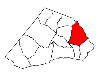
Anderson Creek Township is one of thirteen townships in Harnett County, North Carolina, United States. The township had a population of 11,216 according to the 2000 census. It is a part of the Dunn Micropolitan Area, which is also a part of the greater Raleigh–Durham–Cary Combined Statistical Area (CSA) as defined by the United States Census Bureau.
Stewarts Creek Township is one of thirteen townships in Harnett County, North Carolina, United States. The township had a population of 3,482 according to the 2000 census. It is a part of the Dunn Micropolitan Area, which is also a part of the greater Raleigh–Durham–Cary Combined Statistical Area (CSA) as defined by the United States Census Bureau.
Barbecue Township is one of thirteen townships in Harnett County, North Carolina, United States. In the 2010 census, it had a population of 17,033 in 6,330 households. It is a part of the Dunn Micropolitan Area, which is also a part of the greater Raleigh–Durham–Cary Combined Statistical Area (CSA) as defined by the United States Census Bureau.
Buckhorn Township is one of thirteen townships in Harnett County, North Carolina, United States. The township had a population of 1,905 according to the 2000 census. It is a part of the Dunn Micropolitan Area, which is also a part of the greater Raleigh–Durham–Cary Combined Statistical Area (CSA) as defined by the United States Census Bureau.
Hectors Creek Township is one of thirteen townships in Harnett County, North Carolina, United States. The township had a population of 3,629 according to the 2000 census. It is a part of the Dunn Micropolitan Area, which is also a part of the greater Raleigh–Durham–Cary Combined Statistical Area (CSA) as defined by the United States Census Bureau.
Upper Little River Township is one of thirteen townships in Harnett County, North Carolina, United States. The township had a population of 7,708 according to the 2000 census. It is a part of the Dunn Micropolitan Area, which is also a part of the greater Raleigh–Durham–Cary Combined Statistical Area (CSA) as defined by the United States Census Bureau.
Kipling is an unincorporated community located along U.S. Highway 401 in the Hectors Creek Township of Harnett County, North Carolina between the communities of Cape Fear and Chalybeate Springs north of Lillington. It is a part of the Dunn Micropolitan Area, which is also a part of the greater Raleigh–Durham–Cary Combined Statistical Area (CSA) as defined by the United States Census Bureau.
Luart is an unincorporated community located along old U.S. Highway 421 in the Upper Little River Township of Harnett County, North Carolina between Mamers and the town of Lillington. It is a part of the Dunn Micropolitan Area, which is also a part of the greater Raleigh–Durham–Cary Combined Statistical Area (CSA) as defined by the United States Census Bureau.
Shawtown is an unincorporated community located in the Lillington Township of Harnett County, North Carolina on the south side of the town of Lillington. It is a part of the Dunn Micropolitan Area, which is also a part of the greater Raleigh–Durham–Cary Combined Statistical Area (CSA) as defined by the United States Census Bureau.
Norrington, North Carolina is a small rural unincorporated community located in Harnett County, North Carolina. It is an African American community located a few miles south of Lillington, North Carolina, the county seat and west of Bunnlevel, North Carolina. The community has been settled as early as the 1860s.