"},"elevation_ft":{"wt":"194"},"coordinates":{"wt":"{{coord|35|19|21|N|78|40|24|W|region:US-NC_type:city|display=inline,title}}"},"postal_code_type":{"wt":"[[ZIP Code]]"},"postal_code":{"wt":"28339"},"area_codes":{"wt":"[[Area codes 910 and 472|910, 472]]"},"blank_name":{"wt":"[[Federal Information Processing Standard|FIPS code]]"},"blank_info":{"wt":"37-21740{{cite web |url=https://www.census.gov |publisher=[[United States Census Bureau]] |access-date=2008-01-31 |title=U.S. Census website }}"},"blank1_name":{"wt":"[[Geographic Names Information System|GNIS]] feature ID"},"blank1_info":{"wt":"2406460{{GNIS|2406460}}"},"website":{"wt":"{{URL|www.erwin-nc.org}}"},"pop_est_as_of":{"wt":""},"pop_est_footnotes":{"wt":""},"population_est":{"wt":""}},"i":0}}]}" id="mwBA">Town in North Carolina, United States
Erwin, North Carolina | |
---|---|
![]() Downtown Erwin | |
Motto: "Front Porch Friends" [1] | |
Location of Erwin, North Carolina | |
Coordinates: 35°19′21″N78°40′24″W / 35.32250°N 78.67333°W | |
Country | United States |
State | North Carolina |
County | Harnett |
Government | |
• Mayor | Randy Baker |
Area | |
• Total | 4.25 sq mi (11.02 km2) |
• Land | 4.22 sq mi (10.92 km2) |
• Water | 0.04 sq mi (0.10 km2) |
Elevation | 194 ft (59 m) |
Population (2020) | |
• Total | 4,542 |
• Density | 1,077.32/sq mi (415.98/km2) |
Time zone | UTC-5 (Eastern (EST)) |
• Summer (DST) | UTC-4 (EDT) |
ZIP Code | 28339 |
Area codes | 910, 472 |
FIPS code | 37-21740 [4] |
GNIS feature ID | 2406460 [3] |
Website | www |
Erwin is a town that is located in the eastern part of Harnett County, North Carolina, United States, located approximately 5 miles (8.0 km) from Dunn and approximately 20 miles (32 km) from Fayetteville. The city is a part of the Dunn, NC Micropolitan Statistical Area, which is additionally a part of the greater Raleigh-Durham-Cary, NC CSA, according to the United States Census Bureau. Currently, the city has a population of 5,270 as of the 2020 census. Its current mayor is Randy Baker, who has been the mayor since being elected on May 17, 2022.
Prior to Erwin, there was a colonial-era settlement in the area known as "Averasboro". The Battle of Averasborough was fought nearby during the American Civil War. In 1902, the Duke family built the Erwin Cotton Mill, which closed on December 1, 2000, due to the North American Free Trade Agreement increasing the labor costs of the mill workers, leaving Swift Textiles to relocate the mill's operations to Mexico. [5] [6] The new town was named "Duke" after the founding shareholders. In 1925, the name was changed to "Erwin" because of the formation of Duke University in Durham, North Carolina. [7] Oak Grove, Averasboro Battlefield Historic District, and Downtown Erwin [8] are listed on the National Register of Historic Places. [9]
According to the United States Census Bureau, the town of Erwin has a total area of 4.23 square miles (10.95 km2), of which 0.04 square miles (0.10 km2), or 0.91%, are water. [10] The Cape Fear River forms part of the western border of the town. Juniper Creek, a tributary to the Cape Fear River, enters in Erwin.
By road
US 421: The highway enters the city from the northwest, and continues into Dunn, North Carolina, where it meets with
I-95, a major north–south highway across the East Coast.
NC 217: This short highway enters the city from the south, and its northern terminus is to the north of the city, where it intersects with
US 421. [11]
NC 82: This highway also enters the city from the south, and it meets with
NC 217 through the center of Erwin, known as 13th Street. The highway, with
NC 217, ends at
US 421 in the northern part of the city.
By air
Harnett Regional Jetport is the only airport in the city, which is 10 miles near Buies Creek, NC. The airport currently does not support any airlines yet.
RDU Airport: Although not in the city, the airport serves the Triangle area, which includes Erwin.
By transit
There are no public transportation services that currently service the city.
Carpool services, such as Uber or Lyft are available 24 hours a day, seven days a week to and from the city.
Coats-Erwin Middle
Erwin Elementary: Merged with Gentry to form the new Erwin Elementary, which opened on April 18, 2022. [12]
Census | Pop. | Note | %± |
---|---|---|---|
1950 | 3,344 | — | |
1960 | 3,183 | −4.8% | |
1970 | 2,852 | −10.4% | |
1980 | 2,828 | −0.8% | |
1990 | 4,061 | 43.6% | |
2000 | 4,537 | 11.7% | |
2010 | 4,405 | −2.9% | |
2020 | 4,542 | 3.1% | |
U.S. Decennial Census [13] |
Race | Number | Percentage |
---|---|---|
White (non-Hispanic) | 2,900 | 63.85% |
Black or African American (non-Hispanic) | 794 | 17.48% |
Native American | 28 | 0.62% |
Asian | 9 | 0.2% |
Pacific Islander | 6 | 0.13% |
Other/Mixed | 193 | 4.25% |
Hispanic or Latino | 612 | 13.47% |
As of the 2020 United States census, there were 4,542 people, 1,890 households, and 1,254 families residing in the town.
As of the census [4] of 2000, there were 4,537 people, 1,896 households, and 1,287 families residing in the town. The population density was 1,128.8 inhabitants per square mile (435.8/km2). There were 2,032 housing units at an average density of 505.6 per square mile (195.2/km2). The racial makeup of the town was 80.63% White, 15.96% African American, 0.55% Native American, 0.09% Asian, 1.79% from other races, and 0.99% from two or more races. Hispanic or Latino of any race were 4.14% of the population.
There were 1,896 households, out of which 29.2% had children under the age of 18 living with them, 50.9% were married couples living together, 12.5% had a female householder with no husband present, and 32.1% were non-families. Of all households, 28.3% were made up of individuals, and 14.9% had someone living alone who was 65 years of age or older. The average household size was 2.38 and the average family size was 2.90.
In the town, the population was spread out, with 23.7% under the age of 18, 6.9% from 18 to 24, 27.9% from 25 to 44, 23.5% from 45 to 64, and 17.9% who were 65 years of age or older. The median age was 39 years. For every 100 females, there were 90.9 males. For every 100 females age 18 and over, there were 89.0 males.
The median income for a household in the town was $29,521, and the median income for a family was $41,270. Males had a median income of $29,610 versus $22,650 for females. The per capita income for the town was $18,282. About 16.4% of families and 20.7% of the population were below the poverty line, including 22.2% of those under age 18 and 31.3% of those age 65 or over.[ citation needed ]
Erwin currently has two schools: Erwin Elementary at Gentry (until December 22, 2021), and Triton High School.
![]() | This section needs to be updated.(December 2018) |
In early 2012, Erwin became home to the tallest sphere-topped water tower. The 219.75-foot (66.98 m) structure is about eight feet (2.4 m) taller than the previous record holder, the Union Watersphere in Union, New Jersey. [15] However, photographs of the Erwin water tower revealed the new tower to be a water spheroid, not an actual water sphere (pictured). [16]
Washington County is a county located in the U.S. state of North Carolina. As of the 2020 census, the population was 11,003. Its county seat is Plymouth. The county was formed in 1799 from the western third of Tyrrell County. It was named for George Washington.
Forsyth County is a county located in the northwest Piedmont of the U.S. state of North Carolina. As of the 2020 census, the population was 382,590, making it the fourth-most populous county in North Carolina. Its county seat is Winston-Salem. Forsyth County is part of the Winston-Salem, NC, Metropolitan Statistical Area, which is also included in the Greensboro–Winston-Salem–High Point, NC, Combined Statistical Area. Portions of Forsyth County are in the Yadkin Valley wine region.
Calhoun County is a county located in the U.S. state of Mississippi. As of the 2020 census, the population was 13,266. Its county seat is Pittsboro. The county is named after John C. Calhoun, the U.S. Vice President and U.S. Senator from South Carolina.
Sparta is a town and the county seat of Alleghany County, North Carolina, United States. As of the 2020 census, the population of the town was 1,834.
Belville is a town in Brunswick County, North Carolina, United States. The population was 1,936 at the 2010 census, up from 285 in 2000. It is part of the Wilmington, NC metropolitan area.
Valdese is a town in Burke County, North Carolina, United States. The population was 4,689 at the 2020 census. It is part of the Hickory-Lenoir-Morganton Metropolitan Statistical Area. One of the largest Waldensian congregations in the United States was founded in the town in the late nineteenth century, now known as the Waldensian Presbyterian Church. The town was settled by immigrants from the Cottian Alps in the Piedmont region of Italy.
Spring Lake is a town in Cumberland County, North Carolina, United States. The 2010 census recorded the population at 11,964 people, with an estimated population in 2019 of 12,005.
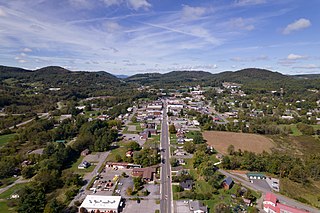
Walkertown is a town in Forsyth County, North Carolina, United States and a rural area outside of Winston-Salem. It is part of the Piedmont Triad. The population was 5,695 at the 2020 census.
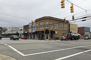
Snow Hill is a town in Greene County, North Carolina, United States. The population was 1,595 at the 2010 census. It is the county seat of Greene County and is part of the Greenville Metropolitan Area. Snow Hill hosts numerous tennis tournaments during the year. Snow Hill is home to the Green Ridge Racquet Club. Many junior players and adults travel to Snow Hill in order to play in the USTA Sanctioned tournaments.
Walstonburg is a town in Greene County, North Carolina, United States. The population was 219 at the 2010 census. It is located north of Snow Hill on North Carolina Highway 91. The town is part of the Greenville Metropolitan Area.
Oak Ridge is a town in northwestern Guilford County, North Carolina, United States. The population was 6,185 at the 2010 census, up from 3,988 in 2000. As of 2018, the population had risen to an estimated 6,977. Oak Ridge is 15 miles (24 km) northwest of the center of Greensboro, North Carolina's third-largest city, and it is a part of the Piedmont Triad urban area.
Angier is a town in the Black River Township of Harnett County, North Carolina, United States. The population was 4,350 at the 2010 census and estimated as of 2018 to be 5,253. Angier is a part of the greater Raleigh–Durham–Cary Combined Statistical Area (CSA) as defined by the United States Census Bureau.
Buies Creek is a census-designated place (CDP) located in the Neills Creek Township of Harnett County, North Carolina, United States. It is the home of Campbell University. The population was 3,253 at the 2020 census, up from 2,942 in 2010. Buies Creek is a part of the Dunn Micropolitan Area, which is also a part of the greater Raleigh–Durham–Cary Combined Statistical Area (CSA) as defined by the United States Census Bureau.
Selma is a town in Johnston County, North Carolina, United States. In 2010, the population was 6,073, and as of 2018 the estimated population was 6,913. Selma is part of the Raleigh-Durham-Cary Combined Statistical Area. The area has a population over 1.7 million residents, though the town of Selma is able to maintain its rural character. The Everitt P. Stevens House, located in Selma, was the site of the last Grand Review of the Confederate Army held on April 6, 1865, after its defeat at the Battle of Bentonville.
Sanford is a city in Lee County, North Carolina, United States. The population was 30,261 at the 2020 census. It is the county seat of Lee County. The geographic center of North Carolina is located northwest of the city, in Chatham County.
La Grange is a town in Lenoir County, North Carolina, United States. The population was 2,873 based on the 2010 census. La Grange is located in North Carolina's Inner Banks region.
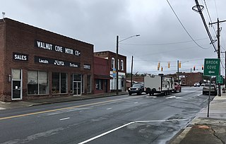
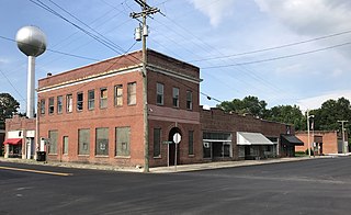
Walnut Cove is a town in Stokes County, North Carolina, United States. The population was 1,536 at the 2020 census.
Fremont is a town in Wayne County, North Carolina, United States. The population was 1,255 at the 2010 census. It is included in the Goldsboro, North Carolina Metropolitan Statistical Area.
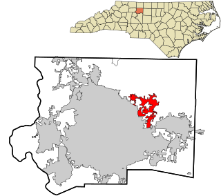
Kernersville is a town in Forsyth County, North Carolina, and the largest suburb of Winston-Salem. A small portion of the town is also in Guilford County. The population was 26,481 at the 2020 census, up from 23,123 in 2010. Kernersville is located at the center of the Piedmont Triad metropolitan area, between Greensboro to the east, High Point to the south, and Winston-Salem to the west. Some of the farmland surrounding the town has been sold and turned into large middle-to-upper-class housing developments.
Mount Olive is a town in Duplin and Wayne counties in the U.S. state of North Carolina. The population was 4,589 at the 2010 census. It is included in the Goldsboro, North Carolina Metropolitan Statistical Area. The town is home to the Mt. Olive Pickle Company and the University of Mount Olive.