
Erwin is a town that is located in the eastern part of Harnett County, North Carolina, United States, located approximately 5 miles (8.0 km) from Dunn and approximately 20 miles (32 km) from Fayetteville. The city is a part of the Dunn, NC Micropolitan Statistical Area, which is additionally a part of the greater Raleigh-Durham-Cary, NC CSA, according to the United States Census Bureau. Currently, the city has a population of 5,270 as of the 2020 census. Its current mayor is Randy Baker, who has been the mayor since being elected on May 17, 2022.
The Battle of Averasborough or the Battle of Averasboro, fought March 16, 1865, in Harnett and Cumberland counties, North Carolina, as part of the Carolinas Campaign of the American Civil War, was a prelude to the climactic Battle of Bentonville, which began three days later.

The Battle of Hatchie's Bridge, also known as Battle of Davis Bridge or Matamora, was fought on October 5, 1862, in Hardeman County and McNairy County, Tennessee, as the final engagement of the Iuka–Corinth Campaign of the American Civil War. Confederate Major General Earl Van Dorn's army successfully evaded capture by the Union Army, following his defeat at the Battle of Corinth.

The Battle of Champion Hill of May 16, 1863, was the pivotal battle in the Vicksburg Campaign of the American Civil War (1861–1865). Union Army commander Maj. Gen. Ulysses S. Grant and the Army of the Tennessee pursued the retreating Confederate States Army under Lt. Gen. John C. Pemberton and defeated it twenty miles to the east of Vicksburg, Mississippi, leading inevitably to the siege of Vicksburg and surrender. The battle is also known as Baker's Creek.
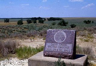
Sand Creek Massacre National Historic Site is a National Historic Site in Kiowa County, Colorado, commemorating the Sand Creek Massacre that occurred here on November 29, 1864. The site is considered sacred after the unprovoked assault on an encampment of approximately 750 Native people resulted in the murder of hundreds of men, women and children. Near Eads and Chivington, the site is about 170 miles (270 km) southeast of Denver and about 125 miles (200 km) east of Pueblo. A few basic park facilities have been opened at this site.

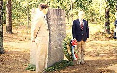
The American Battlefield Trust is a charitable organization whose primary focus is in the preservation of battlefields of the Revolutionary War, the War of 1812, and the American Civil War, through the acquisition of battlefield land. The American Battlefield Trust was formerly known as the Civil War Trust. On May 8, 2018, the organization announced the creation of the American Battlefield Trust as the umbrella organization for two divisions, the Civil War Trust and the Revolutionary War Trust, which was formerly known as "Campaign 1776."

Cowpens National Battlefield is a unit of the National Park Service just east of Chesnee, South Carolina, and near the state line with North Carolina. It preserves a major battlefield of the American Revolutionary War.
Guilford Courthouse National Military Park, at 2332 New Garden Road in Greensboro, Guilford County, North Carolina, commemorates the Battle of Guilford Court House, fought on March 15, 1781. This battle opened the campaign that led to American victory in the Revolutionary War. The loss by the British in this battle contributed to their surrender at Yorktown seven months later. The battlefield is preserved as a National Military Park and operated by the National Park Service (NPS). Based on research of historical evidence, the interpretation of the battle has changed since the late 20th century, which will affect the placement of monuments and markers.
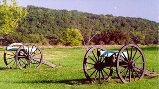
Wilson's Creek National Battlefield, located near Republic, Missouri, preserves the site of the Battle of Wilson's Creek. Fought on August 10, 1861, the battle was the first major American Civil War engagement west of the Mississippi River. In the battle, a Confederate army commanded by Benjamin McCulloch and Sterling Price defeated a smaller Union army commanded by Nathaniel Lyon. However, the Confederates were unable to hold much of Missouri, and a Confederate defeat at the Battle of Pea Ridge effectively solidified Union control of the state. Major features include a five-mile automobile tour loop, the restored 1852 Ray House, and "Bloody Hill", the site of the final stage of the battle. The site is located near Republic in southwestern Missouri just southwest of the city of Springfield. It has been a unit of the National Park Service since 1960, and was listed on the National Register of Historic Places in 1966.

Cedar Creek and Belle Grove National Historical Park became the 388th unit of the United States National Park Service when it was authorized on December 19, 2002. The National Historical Park was created to protect several historically significant locations in the Shenandoah Valley of Northern Virginia, notably the site of the American Civil War Battle of Cedar Creek and the Belle Grove Plantation.

Bentonville Battlefield is a North Carolina state historic site at 5466 Harper House Road in Johnston County, North Carolina. It belongs to the North Carolina Department of Natural and Cultural Resources and is the site of the 1865 Battle of Bentonville, fought in the waning days of the American Civil War. It was declared a National Historic Landmark in 1996.
The Camden Battlefield is the site of the Battle of Camden on 16 August 1780, a British victory by General Charles Cornwallis over a mixed force of Continental Army regulars and state militia forces led by General Horatio Gates. The battlefield sprawls over an area estimated to be 2,000 acres (8.1 km2) about 6 miles (9.7 km) north of Camden, South Carolina, bounded on the north by Lake Shamokin, and extending south. Flat Rock Rd (S-28-58) passes roughly through the center of the battlefield, and United States Route 521 marks its eastern boundary. The American Battlefield Trust and its partners have acquired and preserved more than 294 acres of the battlefield as of mid-2023. It was declared a National Historic Landmark in 1961.

The Princeton Battlefield in Princeton, Mercer County, New Jersey, United States, is where American and British troops fought each other on January 3, 1777, in the Battle of Princeton during the American Revolutionary War. The battle ended when the British soldiers in Nassau Hall surrendered. This success, following those at the Battle of Trenton on December 26, 1776, and the Battle of the Assunpink Creek the day before, helped improve American morale.

The Petersburg Breakthrough Battlefield is a historic district in Dinwiddie County, near Petersburg, Virginia. It was the location of the Third Battle of Petersburg, in which the Union Army broke through Confederate Army lines protecting Petersburg and Richmond on April 2, 1865, during the American Civil War. The success of the breakthrough led to abandonment of Richmond by General Robert E. Lee, a general retreat, and surrender at Appomattox Court House one week later. Portions of the area were listed on the National Register of Historic Places in 2003, and a different portion was designated a National Historic Landmark in 2006. Much of the battlefield area is part of Pamplin Historical Park, a private park open to the public that interprets the battle. The park includes a full-service visitor center, trails, displays, interpretive signs and history programs. The Civil War Trust and its partners have acquired and preserved 407 acres (1.65 km2) of the Breakthrough battlefield in five transactions since 2004.

The Gettysburg Battlefield Historic District is a district of contributing properties and over 1000 historic contributing structures and 315 historic buildings, located in Adams County, Pennsylvania. The district was added to the National Register of Historic Places on March 19, 1975. Most of the contributing elements of the Gettysburg Battlefield are on the protected federal property within the smaller Gettysburg National Military Park.

The Battle of Bentonville was fought in Johnston County, North Carolina, near the village of Bentonville, as part of the Western Theater of the American Civil War. It was the last battle between the armies of Union Maj. Gen. William T. Sherman and Confederate Gen. Joseph E. Johnston.
Cool Spring Battlefield is a historic American Civil War battlefield and national historic district located near Berryville, Clarke County, Virginia. It encompasses 17 contributing buildings, 26 contributing sites, and 11 contributing structures. The district includes the terrain and hydrography over which the Battle of Cool Spring, July 16–20, 1864, was fought and which served to shape the tactical progress of the engagement in time and space. The district also includes the archaeological and architectural remnants of plantations, farmsteads, transportation, mining, and industrial centers that were a part of the economically prosperous community over which the conflict was fought. Located in the district is the separately listed Wickliffe Church.
The Averasboro Battlefield and Museum is dedicated to the Battle of Averasborough, a Civil War battle fought on March 16, 1865. The museum, founded in 1994 by the Averasboro Battlefield Commission, Inc, is located on the battlefield in Dunn, North Carolina. The battlefield attained National Register Historic District status in May 2001. Also on the battlefield and considered to be part of the museum is the restored Chicora Civil Cemetery.
The First Battle of Newtonia Historic District, near Newtonia, Missouri, is a National Register of Historic Places (NRHP) site that preserves the location of the First Battle of Newtonia, an 1862 battle during the American Civil War. The battle saw Confederate troops under Colonels Douglas H. Cooper and Joseph O. Shelby defeat a Union force commanded by Brigadier General Frederick Salomon. The historic district contains some Civil War-period structures, as well as the Mathew H. Ritchey House, which is listed separately on the NRHP.
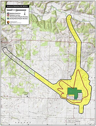
The Second Battle of Newtonia Site is a battlefield listed on the National Register of Historic Places (NRHP) near Newtonia and Stark City in Missouri. In late 1864, Major General Sterling Price of the Confederate States Army began a raid into Missouri in hopes of diverting Union troops away from more important theaters of the American Civil War. After a defeat at the Battle of Westport on October 23, Price's Army of Missouri began retreating through Kansas, but suffered three consecutive defeats on October 25. By October 28, the retreating Confederates had reached Newtonia, where the Second Battle of Newtonia broke out when Union pursuers caught up with the Confederates. Confederate cavalry under Brigadier General Joseph O. Shelby was initially successful, but after Union reinforcements under Brigadier General John B. Sanborn counterattacked, the Confederates withdrew. The Union troops did not pursue, and Price's men escaped, eventually reaching Texas by December.


