Limekilns, New South Wales

Last updated
Limekilns
New South Wales
Australia New South Wales location map blank.svg
Red pog.svg
Limekilns
Coordinates 33°16′35″S149°44′16″E / 33.2764399°S 149.7376513°E / -33.2764399; 149.7376513 Coordinates: 33°16′35″S149°44′16″E / 33.2764399°S 149.7376513°E / -33.2764399; 149.7376513
Population 111 (2016 census) [1]
Postcode(s) 2795
LGA(s) Bathurst Regional Council
State electorate(s) Bathurst
Federal Division(s) Calare

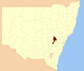
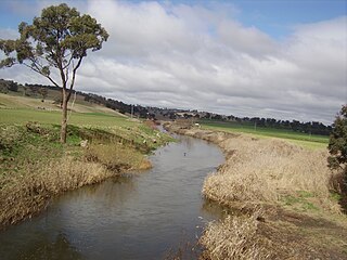
Limekilns is a rural locality in the Central West region of New South Wales. The closest major town is Bathurst, and the local government area is the Bathurst Regional Council. Limekilns had a population of 111 people at the time of the 2016 Australian census. [1]

Central West (New South Wales) Region in New South Wales, Australia

The Central West is a region of New South Wales, Australia. The region is geographically in eastern New South Wales, in the area west of the Blue Mountains, which are west of Sydney. It has an area of 63,262 square kilometres (24,426 sq mi).

New South Wales State of Australia

New South Wales is a state on the east coast of Australia. It borders Queensland to the north, Victoria to the south, and South Australia to the west. Its coast borders the Tasman Sea to the east. The Australian Capital Territory is an enclave within the state. New South Wales' state capital is Sydney, which is also Australia's most populous city. In September 2018, the population of New South Wales was over 8 million, making it Australia's most populous state. Just under two-thirds of the state's population, 5.1 million, live in the Greater Sydney area. Inhabitants of New South Wales are referred to as New South Welshmen.

Bathurst, New South Wales City in New South Wales, Australia

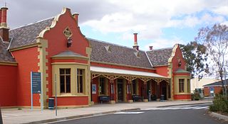
Bathurst is a regional city in the Central Tablelands of New South Wales, Australia. It is about 200 kilometres (120 mi) west-northwest of Sydney and is the seat of the Bathurst Regional Council. Bathurst is the oldest inland settlement in Australia and had a population of approximately 35,000 as at the 2016 Census.

Ben Chifley, the Prime Minister of Australia from 1945 to 1949, lived with his grandfather in Limekilns between the ages of five and thirteen. Another notable resident was Daniel Clyne, a Speaker of the New South Wales Legislative Assembly. [2]

Ben Chifley Australian politician, 16th Prime Minister of Australia

Joseph Benedict Chifley was an Australian politician who served as the 16th Prime Minister of Australia, in office from 1945 to 1949. He was leader of the Labor Party from 1945 until his death.

Prime Minister of Australia executive head of the Government of Australia

The Prime Minister of Australia is the head of government of Australia. The individual who holds the office is the most senior Minister of State, the leader of the Federal Cabinet. The Prime Minister also has the responsibility of administering the Department of the Prime Minister and Cabinet, and is the chair of the National Security Committee and the Council of Australian Governments. The office of Prime Minister is not mentioned in the Constitution of Australia but exists through Westminster political convention. The individual who holds the office is commissioned by the Governor-General of Australia and at the Governor-General's pleasure subject to the Constitution of Australia and constitutional conventions.

Daniel Clyne Australian politician

Daniel Clyne was an Australian politician. He was a member of the New South Wales Legislative Assembly from 1927 until 1956 and, variously, a member of the Labor Party (ALP) and Lang Labor. He was the Speaker of the New South Wales Legislative Assembly between 1941 and 1947.

A book about the area, written by Col Ferguson and titled The History of Limekilns, was published in 2017. [3]

Related Research Articles

Local government areas of New South Wales Wikimedia list article

The local government areas (LGA) of New South Wales in Australia describes the institutions and processes by which areas, cities, towns, municipalities, regions, shires, and districts can manage their own affairs to the extent permitted by the Local Government Act 1993 (NSW).

Division of Macquarie Australian federal electoral division

The Division of Macquarie is an Australian electoral division in the state of New South Wales. The division was created in 1900 and was one of the original 65 divisions contested at the first federal election. It is named for Lachlan Macquarie, who was Governor of New South Wales between 1810 and 1821.

Dharruk, New South Wales Suburb of Sydney, New South Wales, Australia

Dharruk is a suburb of Sydney, in the state of New South Wales, Australia. It is located 46 kilometres west of the Sydney central business district, in the local government area of the City of Blacktown and is part of the Greater Western Sydney region.

City of Randwick Local government area in New South Wales, Australia

The City of Randwick is a local government area in the eastern suburbs of Sydney, New South Wales, Australia. Established in 1859, Randwick is the second-oldest local government area in New South Wales, after the City of Sydney. It comprises an area of 36 square kilometres (14 sq mi) and as at the 2016 census had a population of 140,660.

Chifley, New South Wales Suburb of Sydney, New South Wales, Australia

Chifley is a suburb in south-eastern Sydney, in the state of New South Wales, Australia. Chifley is 13 km south-east of the Sydney central business district and is part of the City of Randwick. The postcode is 2036. Chifley is surrounded by the suburbs of Matraville, Malabar, Little Bay and Phillip Bay.

Bathurst railway station, New South Wales

Bathurst railway station is a heritage-listed railway station at Havannah Street, Bathurst, Bathurst Region, New South Wales, Australia. It is situated on the Main Western line and serves the city of Bathurst. It was added to the New South Wales State Heritage Register on 2 April 1999.

Bathurst Region Local government area in New South Wales, Australia

The Bathurst Region is a local government area in the Central West region of New South Wales, Australia. The area is located adjacent to the Great Western Highway, Mid-Western Highway, Mitchell Highway and the Main Western railway line. At the 2016 census, the Bathurst Region had a population of 41,300.

Lake Bathurst (New South Wales) Town in New South Wales, Australia

Lake Bathurst is a shallow lake located 27 kilometres (17 mi) south-east of Goulburn, New South Wales in Australia. It is also the name of a nearby locality in the Goulburn Mulwaree Council.

Campbells River river in Australia

Campbells River, a perennial stream that is part of the Upper Macquarie catchment within the Murray–Darling basin, is located in the central–western region of New South Wales, Australia.

Winburndale Dam

Winburndale Dam is a concrete gravity dam on the Winburndale Rivulet in New South Wales. Its height is 22 metres (72 ft) and holds back 1,700 megalitres of water. The dam is situated within the Winburndale Nature Reserve, 19 kilometres (12 mi) East of Bathurst, New South Wales. There is no public access to the dam.

Christopher Augustus "Gus" Kelly was an Australian politician. He was a Labor Party member of the New South Wales Legislative Assembly from 1925 to 1932 and again from 1935 until his death in 1967, representing the electorate of Bathurst. He held numerous ministerial positions between 1941 and 1965 in McKell Labor Government.

Ben Chifley Dam embankment dam in New South Wales, Australia

Ben Chifley Dam, or Chifley Dam, is a rock and earth-fill embankment dam across the Campbells River in the central west region of New South Wales, Australia. The main purpose of the dam is to supply potable water to the city of Bathurst.

West Bathurst, New South Wales Suburb of Bathurst Region, New South Wales, Australia

West Bathurst is a suburb of Bathurst in the Bathurst Region, New South Wales, Australia.

<i>The National Advocate</i>

The National Advocate was a daily newspaper published in Bathurst, New South Wales, Australia, between 1889 and 1963.

Llanarth, New South Wales Town in New South Wales, Australia

Llanarth is a locality in the Bathurst Region of New South Wales, Australia, approximately 3km from Bathurst. It was named after the historic Llanarth property, established in 1858 by the Smith family after their previous home of Llanarth in Cornwall. It had a population of 2,198 people as of the 2016 census.

Raglan, New South Wales Town in New South Wales, Australia

Raglan is a locality in the Bathurst Region of New South Wales, Australia. It was named after FitzRoy Somerset, 1st Baron Raglan, commander-in-chief of the Allied forces in the Crimean War from 1850 to 1855. It had a population of 1,199 people as of the 2016 census.

Georges Plains, New South Wales Town in New South Wales, Australia

Georges Plains is a locality in the Bathurst Region of New South Wales, Australia. It had a population of 248 people as of the 2016 census.

Ben Chifleys House residence of the 16th Prime Minister of Australia

Ben Chifley's House is a heritage-listed former residence and now house museum at 10 Busby Street, Bathurst, Bathurst Region, New South Wales, Australia. It was built from 1887 to 1891. It is also known as Carnwath, Chifley Residence, Chifley House Museum and Chifley Home. The property is owned by Bathurst Regional Council. It was added to the New South Wales State Heritage Register on 23 December 2002.

References

  1. 1 2 2016 Census QuickStats: Limekilns. Retrieved 2 January 2018.
  2. Crisp, L.F. (1961), Ben Chifley: A Political Biography, Angus & Robertson Publishers, pp. 3–5.
  3. Rural Notebook | Hit-and-miss storms and Limekilns history collected, Oberon Review, 2 December 2017. Retrieved 2 January 2018.