Lindeman Fjord

Last updated
Lindeman Fjord
Lindeman Bugt
Clavering 1932.tif
Map section showing the Lindeman Fjord area.
Greenland edcp relief location map.jpg
Red pog.svg
Lindeman Fjord
Location in Greenland
Location Arctic
Coordinates 74°40′N20°45.4′W / 74.667°N 20.7567°W / 74.667; -20.7567 Coordinates: 74°40′N20°45.4′W / 74.667°N 20.7567°W / 74.667; -20.7567
Ocean/sea sources Hochstetter Bay
Greenland Sea
Basin  countries Greenland
Max. length25 kilometres (16 mi)
Max. width5 kilometres (3.1 mi)
FrozenMost of the year

Lindeman Fjord is a fjord in King Christian X Land, East Greenland. Administratively it is part of the Northeast Greenland National Park zone.

Contents

History

The outer part of the fjord was first surveyed by Carl Koldewey during the 1869–70 Second German North Polar Expedition. Koldewey named it Lindeman Bai after Moritz Karl Adolf Lindeman (1823 – 1908), secretary of the Association for German Polar Exploration (Verein für die Deutsche Nordpolarfahrt) in Bremen. [1]

Later, during the 1929–1930 Expedition to East Greenland led by Lauge Koch, more thorough surveys were made and the fjord was found to become narrow to the west and extend further inland, thus the water body was renamed "Lindeman Fjord". [1]

Geography

Lindeman Fjord opens to the east, southwest of Kuhn Island and south of the mouth area of Fligely Fjord. It extends southwest of Kuhn Island, west of Cape Schumacher at the southern end of the island. To the south lies A. P. Olsen Land and Thomas Thomsen Land lies to the north. [2]

The fjord is about 5 kilometres (3.1 mi) wide at the entrance and stretches to the west for about 25 kilometres (16 mi), curving slightly southwestwards and narrowing to less than 2.5 kilometres (1.6 mi) before the head. [3] A massive mountain named Hohe Kugel rises north of the mouth of the fjord. Svejstrup Dal, a long valley at the head of Lindemann Fjord, stretches northwestwards between A. P. Olsen Land and Thomas Thomsen Land [1]

Map of Northeastern Greenland Operational Navigation Chart B-9, 1st edition.jpg
Map of Northeastern Greenland
East Greenland Terra/MODIS satellite image Greenland.A2003233.1340.250m.jpg
East Greenland Terra/MODIS satellite image

See also

Related Research Articles

Kaiser Franz Joseph Fjord fjord in Greenland

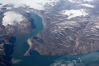
Kaiser Franz Joseph Fjord is a major fjord system in the NE Greenland National Park area, East Greenland.

Wollaston Foreland peninsula in Greenland

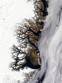
Wollaston Foreland is a peninsula in King Christian X Land, East Greenland. Administratively it belongs to the NE Greenland National Park area.

Germania Land peninsula in Greenland

Germania Land or Germanialand is a peninsula in northeastern Greenland. Despite the high latitude it is largely unglaciated.

Kuhn Island isle in Greenland

Kuhn Island is a coastal island in Hochstetter Bay, eastern Greenland. There are coal deposits on the island.

Bessel Fjord fjord in Greenland

Bessel Fjord is a fjord in northeastern Greenland. Administratively it belongs to the NE Greenland National Park area.

Iluileq island in Greenland

Iluileq is an uninhabited island in the Kujalleq municipality in southern Greenland.

Dove Bay bay in Greenland

Dove Bay is a bay in King Frederick VIII Land, northeastern Greenland. It is part of the Northeast Greenland National Park area.

Adolf S. Jensen Land peninsula in Greenland

Adolf S. Jensen Land is a peninsula in the southern limit of King Frederick VIII Land, northeastern Greenland. Administratively it belongs to the NE Greenland National Park area.

Ardencaple Fjord fjord in Greenland

Ardencaple Fjord is a fjord in King Christian X Land, northeastern Greenland. Administratively it is part of the Northeast Greenland National Park.

Roosevelt Range mountain range in Greenland

The Roosevelt Range or Roosevelt Mountains is a mountain range in Northern Greenland. Administratively this range is part of the Northeast Greenland National Park. Its highest peak is the highest point in Peary Land.

Carlsberg Fjord fjord in Greenland

Carlsberg Fjord is a fjord in King Christian X Land, eastern Greenland.

Peters Bay bay of the Greenland Sea in King Christian X Land, Greenland

Peters Bay is a bay of the Greenland Sea in King Christian X Land, Greenland. Administratively it belongs to the NE Greenland National Park area.

Godthab Gulf

Godthab Gulf, also known as Godthaab Golf, Clavering Fjord, Clavering Sound and Inner Bay, is a fjord in King Christian X Land, East Greenland. Administratively it is part of the Northeast Greenland National Park zone.

Young Sound sound in Greenland

Young Sound is a marine channel with a fjord structure in King Christian X Land, East Greenland. Administratively it is part of the Northeast Greenland National Park zone.

Fligely Fjord

Fligely Fjord is a fjord in King Christian X Land, East Greenland. Administratively it is part of the Northeast Greenland National Park zone.

Tyrolerfjord fjord in Greenland

Tyrolerfjord is a fjord in King Christian X Land, East Greenland. Administratively it is part of the Northeast Greenland National Park zone.

Nansen Land

Nansen Land is a peninsula in far northwestern Greenland. It is a part of the Northeast Greenland National Park.

Grandjean Fjord

Grandjean Fjord is a fjord in King Christian X Land, East Greenland. Administratively it is part of the Northeast Greenland National Park zone.

Muskox Fjord fjord in Greenland

Muskox Fjord is a fjord in King Christian X Land, East Greenland. Administratively it lies in the Northeast Greenland National Park area. This fjord is part of the Kaiser Franz Joseph Fjord system.

Kjerulf Fjord fjord in Greenland

Kjerulf Fjord is a fjord in King Christian X Land, eastern Greenland.

References

  1. 1 2 3 "Catalogue of place names in northern East Greenland". Geological Survey of Denmark. Retrieved 20 September 2019.
  2. "Lindeman Fjord". Mapcarta. Retrieved 21 September 2019.
  3. Prostar Sailing Directions 2005 Greenland and Iceland Enroute, p. 123