
Lindinis or Lendiniae was a small town in the Roman province of Britannia. Today it is known as Ilchester, located in the English county of Somerset in the United Kingdom.
Lindinis or Lendiniae was a small town in the Roman province of Britannia. Today it is known as Ilchester, located in the English county of Somerset in the United Kingdom.
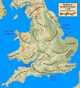
The name "Lindinis" appears in the 7th-century Ravenna Cosmography . The alternative *Lendiniae is derived from two inscribed construction stones from Hadrian's Wall which refer to a detachment from the Lendinienses tribe of the Durotriges" (Latin : Civitas Durotragum Lendiniensis). [1] [2] The inscriptions seem to imply that the town was a separate tribal capital from the known one at Dorchester ( Durnovaria ). [1] It appears to be a Latinization of the Brittonic for "swampy lake".
There were two large Iron Age hillforts in the region of Lindinis at Ham Hill and Cadbury. There was also a small settlement to the south of the site of the later Roman town.
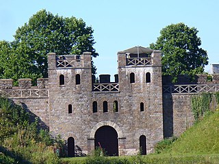
A timber-walled fort (Latin : castrum) was established at Ilchester around AD 60 and later a second fort seems to have been built. It protected the crossing of the Fosse Way over the River Yeo. Originally surrounded by native round houses, these were later supplanted by an unplanned settlement ( vicus ) of around 30 acres (120,000 m2). [3] The post was abandoned in the late 1st century, after which a street grid was set up with timber domestic dwellings and workshops, as well as outer roadside industrial suburbs. There is evidence of iron, glass, and bone working and pottery production, as well as agricultural plots within the town. In the late 2nd century, the central area was surrounded by a defensive bank and ditch with stone gateways. Stone walls were erected in the mid-4th century. It became the only walled town in the territory of the Durotriges other than Durnovaria. [1] By this time, the town seems to have largely consisted of private homes of owners rich enough to install fine mosaic floors. More than thirty have been discovered and it has been suggested that the town contained a workshop of the Corinium Saltire School of mosaicists or else boasted its own 'Lindinis School'. [4]
Pottery imported into the area after the Roman withdrawal from Britain around 410 imply the site continued to be occupied over the next century, although the local elite may have then relocated to the nearby hillfort of South Cadbury. Ford identified Lindinis as the Cair Pensa vel Coyt [5] listed among the 28 cities of Britain by the History of the Britons , taking the name as a reference to Penselwood [6] (coit being Welsh for "forest"), although others such as Mommsen [5] and Ussher instead read vel as the Latin for "or"—"Pensa or Coyt"—and tentatively associate it with Isca at present-day Exeter. [7]
The Dumnonii or Dumnones were a British tribe who inhabited Dumnonia, the area now known as Cornwall and Devon in the further parts of the South West peninsula of Britain, from at least the Iron Age up to the early Saxon period. They were bordered to the east by the Durotriges tribe.
Caer is a placename element in Welsh meaning "stronghold", "fortress", or "citadel", roughly equivalent to an Old English suffix (-ceaster) now variously written as -caster, -cester, and -chester.
Dumnonia is the Latinised name for a Brythonic kingdom that existed in Sub-Roman Britain between the late 4th and late 8th centuries CE in the more westerly parts of present-day South West England. It was centred in the area of modern Devon, but also included modern Cornwall and part of Somerset, with its eastern boundary changing over time as the gradual westward expansion of the neighbouring Anglo-Saxon kingdom of Wessex encroached on its territory. The spelling Damnonia is sometimes encountered, but that spelling is also used for the land of the Damnonii, later part of the Kingdom of Strathclyde, in present-day southern Scotland. The form Domnonia also occurs. The name of the kingdom shares a linguistic relationship with the Breton region of Domnonée.

Ilchester is a village and civil parish, situated on the River Yeo or Ivel, five miles north of Yeovil, in the English county of Somerset. Originally a Roman town, and later a market town, Ilchester has a rich medieval history and was a notable settlement in the county; around the 12th and 13th centuries it was effectively the county town. It had, however, declined in size and importance by the beginning of the 18th century, and the last markets were held in 1833. In 1889 the historic corporation that had governed the town was dissolved.

The Cornovīī were a Celtic people of the Iron Age and Roman Britain, who lived principally in the modern English counties of Cheshire, Shropshire, north Staffordshire, north Herefordshire and eastern parts of the Welsh counties of Flintshire, Powys and Wrexham. Their capital in pre-Roman times was probably a hillfort on the Wrekin. Ptolemy's 2nd-century Geography names two of their towns: Deva Victrix (Chester) and Viroconium Cornoviorum (Wroxeter), which became their capital under Roman rule.
The Durotriges were one of the Celtic tribes living in Britain prior to the Roman invasion. The tribe lived in modern Dorset, south Wiltshire, south Somerset and Devon east of the River Axe and the discovery of an Iron Age hoard in 2009 at Shalfleet, Isle of Wight gives evidence that they may also have lived in the western half of the island. After the Roman conquest, their main civitates, or settlement-centred administrative units, were Durnovaria and Lindinis. Their territory was bordered to the west by the Dumnonii; and to the east by the Belgae.
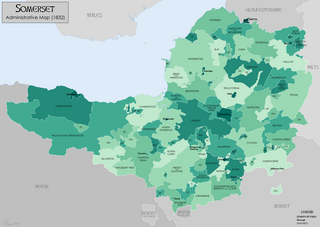
Somerset is a historic county in the south west of England. There is evidence of human occupation since prehistoric times with hand axes and flint points from the Palaeolithic and Mesolithic eras, and a range of burial mounds, hill forts and other artefacts dating from the Neolithic, Bronze and Iron Ages. The oldest dated human road work in Great Britain is the Sweet Track, constructed across the Somerset Levels with wooden planks in the 39th century BCE.

Cadbury Castle is a Bronze and Iron Age hillfort in the civil parish of South Cadbury in the English county of Somerset. It is a scheduled monument and has been associated with King Arthur's legendary court at Camelot.

Badbury Rings is an Iron Age hill fort and Scheduled Monument in east Dorset, England. It was in the territory of the Durotriges. In the Roman era a temple was located immediately west of the fort, and there was a Romano-British town known as Vindocladia a short distance to the south-west.

Durnovaria is a suggested spelling for the Latin form of the name of the Roman town of Dorchester in the modern English county of Dorset, amended from the actually observed Durnonovaria. Upon the assumption that the name was originally Brythonic, it is suggested that the first element in the name, *durno- may mean "fist" like and the second may be related to Old Irish fáir ~ fóir denoting a confined area or den. A simpler amendment would lead to *Duronovaria, making this place one of up to 18 ancient British names that contain Duro- and mostly occur at river crossings, while -novaria has two possible ancient parallels in Britain associated with river junctions. That analysis would perfectly fit the geographical situation of Dorchester.

Isca Dumnoniorum, also known simply as Isca, was originally a Roman legionary fortress for the Second Augustan Legion in the Roman province of Britannia at the site of present-day Exeter in Devon.

The names of the Celtic Iron Age tribes in Britain were recorded by Roman and Greek historians and geographers, especially Ptolemy. Information from the distribution of Celtic coins has also shed light on the extents of the territories of the various groups that occupied the island.

Venta Belgarum, or Venta Bulgarum, was a town in the Roman province of Britannia Superior, the civitas capital of the local tribe, the Belgae, and which later became the city of Winchester.
Penselwood is a village and civil parish in the English county of Somerset. It is located 4 miles (6.4 km) north east of Wincanton, 4 miles (6.4 km) south east of Bruton, 4 miles (6.4 km) west of Mere, and 5 miles (8.0 km) north west of Gillingham. The south-east of the parish borders Zeals and Stourhead in Wiltshire, and Bourton in Dorset. In 1991 the parish occupied 523 hectares.
Luguvalium was an ancient Roman city in northern Britain located within present-day Carlisle, Cumbria, and may have been the capital of the 4th-century province of Valentia. It was the northernmost city of the Roman Empire.

Durovernum Cantiacorum was a town and hillfort in Roman Britain at the site of present-day Canterbury in Kent. It occupied a strategic location on Watling Street at the best local crossing of the Stour, which prompted a convergence of roads connected to the ports of Dubris (Dover), Rutupiae (Richborough), Regulbium (Reculver) and Portus Lemanis (Lympne). Considerable archaeological evidence of Roman activity has been found in Canterbury, much of which can now be found in the Roman Museum built on the remains of a Roman townhouse.

Duroliponte or Durolipons was a small town in the Roman province of Britannia on the site of what is now the city of Cambridge.
Ratae Corieltauvorum or simply Ratae was a town in the Roman province of Britannia. Today it is known as Leicester, located in the English county of Leicestershire.

Moridunum was a Roman fort and town in the Roman province of Britannia. Today it is known as Carmarthen, located in the Welsh county of Carmarthenshire.

Stokeleigh Camp is an Iron Age promontory fort in Leigh Woods North Somerset near Bristol, England. The hill fort is one of three Iron Age fortifications overlooking the Avon Gorge, the others being Burgh Walls Camp south of the Nightingale Valley, of which almost no trace remains, and the other being Clifton Down Camp on the opposite side of the gorge, on Clifton Down near the Observatory. A prehistoric road is believed to have connected Stokeleigh Camp with Cadbury Camp near Tickenham in North Somerset.