
Brackish water, sometimes termed brack water, is water occurring in a natural environment that has more salinity than freshwater, but not as much as seawater. It may result from mixing seawater and fresh water together, as in estuaries, or it may occur in brackish fossil aquifers. The word comes from the Middle Dutch root brak. Certain human activities can produce brackish water, in particular civil engineering projects such as dikes and the flooding of coastal marshland to produce brackish water pools for freshwater prawn farming. Brackish water is also the primary waste product of the salinity gradient power process. Because brackish water is hostile to the growth of most terrestrial plant species, without appropriate management it is damaging to the environment.
The Delta Works is a series of construction projects in the southwest of the Netherlands to protect a large area of land around the Rhine–Meuse–Scheldt delta from the sea. Constructed between 1954 and 1997, the works consist of dams, sluices, locks, dykes, levees, and storm surge barriers located in the provinces of South Holland and Zeeland.

The Eastern Scheldt is a former estuary in the province of Zeeland, Netherlands, between Schouwen-Duiveland and Tholen on the north and Noord-Beveland and Zuid-Beveland on the south. It also features the largest national park in the Netherlands, founded in 2002.

An estuary is a partially enclosed coastal body of brackish water with one or more rivers or streams flowing into it, and with a free connection to the open sea. Estuaries form a transition zone between river environments and maritime environments and are an example of an ecotone. Estuaries are subject both to marine influences such as tides, waves, and the influx of saline water, and to fluvial influences such as flows of freshwater and sediment. The mixing of seawater and freshwater provides high levels of nutrients both in the water column and in sediment, making estuaries among the most productive natural habitats in the world.

Wetlands, or simply a wetland, is a distinct ecosystem that is flooded or saturated by water, either permanently or seasonally. Flooding results in oxygen-free (anoxic) processes prevailing, especially in the soils. The primary factor that distinguishes wetlands from terrestrial land forms or water bodies is the characteristic vegetation of aquatic plants, adapted to the unique anoxic hydric soils. Wetlands are considered among the most biologically diverse of all ecosystems, serving as home to a wide range of plant and animal species. Methods for assessing wetland functions, wetland ecological health, and general wetland condition have been developed for many regions of the world. These methods have contributed to wetland conservation partly by raising public awareness of the functions some wetlands provide. Constructed wetlands are designed and built to treat municipal and industrial wastewater as well as to divert stormwater runoff. Constructed wetlands may also play a role in water-sensitive urban design.

A marsh is — according to ecological definitions — a wetland that is dominated by herbaceous rather than woody plant species. More in general, the word can be used for any low-lying and seasonally waterlogged terrain. In Europe and in agricultural literature low-lying meadows that require draining and embanked polderlands are also referred to as marshes or marshland.
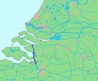
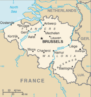
The Scheldt–Rhine Canal (Schelde-Rijnkanaal) in Belgium and the Netherlands connects Antwerp with the Volkerak, and thereby the Scheldt with the Rhine.
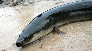
The American eel is a facultative catadromous fish found on the eastern coast of North America. Freshwater eels are fish belonging to the elopomorph superorder, a group of phylogenetically ancient teleosts. The American eel has a slender, supple, snake-like body that is covered with a mucus layer, which makes the eel appear to be naked and slimy despite the presence of minute scales. A long dorsal fin runs from the middle of the back and is continuous with a similar ventral fin. Pelvic fins are absent, and relatively small pectoral fins can be found near the midline, followed by the head and gill covers. Variations exist in coloration, from olive green, brown shading to greenish-yellow and light gray or white on the belly. Eels from clear water are often lighter than those from dark, tannic acid streams.

A salt marsh, saltmarsh or salting, also known as a coastal salt marsh or a tidal marsh, is a coastal ecosystem in the upper coastal intertidal zone between land and open saltwater or brackish water that is regularly flooded by the tides. It is dominated by dense stands of salt-tolerant plants such as herbs, grasses, or low shrubs. These plants are terrestrial in origin and are essential to the stability of the salt marsh in trapping and binding sediments. Salt marshes play a large role in the aquatic food web and the delivery of nutrients to coastal waters. They also support terrestrial animals and provide coastal protection.

The Eel River is a major river, about 196 miles (315 km) long, in northwestern California. The river and its tributaries form the third largest watershed entirely in California, draining a rugged area of 3,684 square miles (9,540 km2) in five counties. The river flows generally northward through the Coast Ranges west of the Sacramento Valley, emptying into the Pacific Ocean about 10 miles (16 km) downstream from Fortuna and just south of Humboldt Bay. The river provides groundwater recharge, recreation, and industrial, agricultural and municipal water supply.

A tidal marsh is a marsh found along rivers, coasts and estuaries which floods and drains by the tidal movement of the adjacent estuary, sea or ocean. Tidal marshes experience many overlapping persistent cycles, including diurnal and semi-diurnal tides, day-night temperature fluctuations, spring-neap tides, seasonal vegetation growth and decay, upland runoff, decadal climate variations, and centennial to millennial trends in sea level and climate.

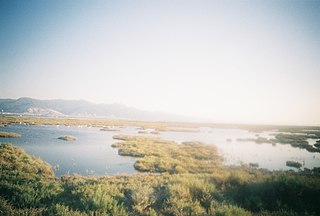
Located in northern California, the Suisun Marsh has been referred to as the largest brackish water marsh on west coast of the United States of America. The marsh land is part of a tidal estuary, and subject to tidal ebb and flood. The marsh is home to many species of birds and other wildlife, and is formed by the confluence of the Sacramento and San Joaquin rivers between Martinez and Suisun City, California and several other smaller, local watersheds. Adjacent to Suisun Bay, the marsh is immediately west of the legally defined Sacramento-San Joaquin Delta as well as part of the San Francisco Bay estuary.
A tidal river is a river whose flow and level are caused by tides. A section of a larger river affected by the tides is a tidal reach, but it may sometimes be considered a tidal river if it had been given a separate and another title name.

The Japanese eel is a species of anguillid eel found in Japan, Korea, Taiwan, China, and Vietnam, as well as the northern Philippines. There are three main species under the Anguilla genus, and all three share very similar characteristics. These species are so similar that it is believed that they spawned from the same species and then experienced a separation due to different environments in the ocean. Like all the eels of the genus Anguilla and the family Anguillidae, it is catadromous, meaning it spawns in the sea but lives parts of its life in freshwater. Raised in aquaculture ponds in most countries, the Japanese eel makes up 95% of the commercially sold eel in Japan, the other 5% is shipped over by air to the country from Europe. This food in Japan is called unagi; they are an essential part of the food culture, with many restaurants serving grilled eel called kabayaki. However, presumably due to a combination of overfishing and habitat loss or changing water conditions in the ocean interfering with spawning and the transport of their leptocephali this species is endangered.
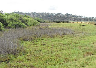
Brackish marshes develop from salt marshes where a significant freshwater influx dilutes the seawater to brackish levels of salinity. This commonly happens upstream from salt marshes by estuaries of coastal rivers or near the mouths of coastal rivers with heavy freshwater discharges in the conditions of low tidal ranges.
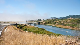
Ten Mile River is in northern Mendocino County, California, United States. It is named for the fact that its mouth is 10 miles (16 km) north of the mouth of the Noyo River. The lands around lower Ten Mile River provide valuable freshwater and saltwater marsh habitat for a variety of birds. The Ten Mile River Estuary, Ten Mile Beach, and Ten Mile State Marine Reserve together form a marine protected area that extends from the estuary out to 5 nautical miles. Ten Mile Beach is also part of MacKerricher State Park, which extends approximately 5 miles (8.0 km) southward from the mouth of the river to Cleone and includes approximately 1,300 acres (526 ha) of the "most pristine stretch of sand dunes [in California]."

A tidal barrage is a dam-like structure used to capture the energy from masses of water moving in and out of a bay or river due to tidal forces.

The Salt River is a formerly navigable hanging channel of the Eel River which flowed about 9 miles (14 km) from near Fortuna and Waddington, California, to the estuary at the Pacific Ocean, until siltation from logging and agricultural practices essentially closed the channel. It was historically an important navigation route until the early 20th century. It now intercepts and drains tributaries from the Wildcat Hills along the south side of the Eel River floodplain. Efforts to restore the river began in 1987, permits and construction began in 2012, and water first flowed in the restored channel in October 2013.
Sedimentation enhancing strategies are environmental management projects aiming to restore and facilitate land-building processes in deltas. Sediment availability and deposition are important because deltas naturally subside and therefore need sediment accumulation to maintain their elevation, particularly considering increasing rates of sea-level rise. Sedimentation enhancing strategies aim to increase sedimentation on the delta plain primarily by restoring the exchange of water and sediments between rivers and low-lying delta plains. Sedimentation enhancing strategies can be applied to encourage land elevation gain to offset sea-level rise. Interest in sedimentation enhancing strategies has recently increased due to their ability to raise land elevation, which is important for the long-term sustainability of deltas.
The Zeeschelde is a part of the Scheldt River, and is of great ecological importance. It is home to numerous water birds and the river is considered a nursery for marine fish. Many young fish use the Zeeschelde as a resting place, only to swim back out to sea a few months later. Sections of the river are under European protection as part of Natura 2000 "Scheldt and Durme estuary from the Dutch border to Ghent" (BE2300006).
