Crop rotation is the practice of growing a series of different types of crops in the same area across a sequence of growing seasons. This practice reduces the reliance of crops on one set of nutrients, pest and weed pressure, along with the probability of developing resistant pests and weeds.

Shifting cultivation is an agricultural system in which plots of land are cultivated temporarily, then abandoned while post-disturbance fallow vegetation is allowed to freely grow while the cultivator moves on to another plot. The period of cultivation is usually terminated when the soil shows signs of exhaustion or, more commonly, when the field is overrun by weeds. The period of time during which the field is cultivated is usually shorter than the period over which the land is allowed to regenerate by lying fallow.

Slash-and-burn agriculture is a farming method that involves the cutting and burning of plants in a forest or woodland to create a field called a swidden. The method begins by cutting down the trees and woody plants in an area. The downed vegetation, or "slash", is then left to dry, usually right before the rainiest part of the year. Then, the biomass is burned, resulting in a nutrient-rich layer of ash which makes the soil fertile, as well as temporarily eliminating weed and pest species. After about three to five years, the plot's productivity decreases due to depletion of nutrients along with weed and pest invasion, causing the farmers to abandon the field and move to a new area. The time it takes for a swidden to recover depends on the location and can be as little as five years to more than twenty years, after which the plot can be slashed and burned again, repeating the cycle. In Bangladesh and India, the practice is known as jhum or jhoom.

Agriculture in Mesoamerica dates to the Archaic period of Mesoamerican chronology. At the beginning of the Archaic period, the Early Hunters of the late Pleistocene era led nomadic lifestyles, relying on hunting and gathering for sustenance. However, the nomadic lifestyle that dominated the late Pleistocene and the early Archaic slowly transitioned into a more sedentary lifestyle as the hunter gatherer micro-bands in the region began to cultivate wild plants. The cultivation of these plants provided security to the Mesoamericans, allowing them to increase surplus of "starvation foods" near seasonal camps; this surplus could be utilized when hunting was bad, during times of drought, and when resources were low. The cultivation of plants could have been started purposefully, or by accident. The former could have been done by bringing a wild plant closer to a camp site, or to a frequented area, so it was easier access and collect. The latter could have happened as certain plant seeds were eaten and not fully digested, causing these plants to grow wherever human habitation would take them.

In agriculture, polyculture is the practice of growing more than one crop species together in the same place at the same time, in contrast to monoculture, which had become the dominant approach in developed countries by 1950. Traditional examples include the intercropping of the Three Sisters, namely maize, beans, and squashes, by indigenous peoples of Central and North America, the rice-fish systems of Asia, and the complex mixed cropping systems of Nigeria.

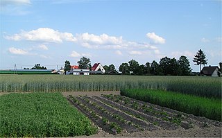
In agriculture, a terrace is a piece of sloped plane that has been cut into a series of successively receding flat surfaces or platforms, which resemble steps, for the purposes of more effective farming. This type of landscaping is therefore called terracing. Graduated terrace steps are commonly used to farm on hilly or mountainous terrain. Terraced fields decrease both erosion and surface runoff, and may be used to support growing crops that require irrigation, such as rice. The Rice Terraces of the Philippine Cordilleras have been designated as a UNESCO World Heritage Site because of the significance of this technique.

The Three Sisters are the three main agricultural crops of various indigenous people of Central and North America: squash, maize ("corn"), and climbing beans. In a technique known as companion planting, the maize and beans are often planted together in mounds formed by hilling soil around the base of the plants each year; squash is typically planted between the mounds. The cornstalk serves as a trellis for climbing beans, the beans fix nitrogen in their root nodules and stabilize the maize in high winds, and the wide leaves of the squash plant shade the ground, keeping the soil moist and helping prevent the establishment of weeds.

Ruvuma Region is one of Tanzania's 31 administrative regions. The region covers a land area of 63,669 km2 (24,583 sq mi), comparable in size to the nation state of Latvia. The region is also bordered to the north by the Morogoro Region, to the northeast by the Lindi Region, to the east by the Mtwara Region,the west by Lake Nyasa with Malawi and to the northwest by the Njombe Region. The regional capital is the municipality of Songea.

Worldwide more human beings gain their livelihood from agriculture than any other endeavor; the majority are self-employed subsistence farmers living in the tropics. While growing food for local consumption is the core of tropical agriculture, cash crops are also included in the definition.

The Matengo are an ethnic and linguistic group based in Mbinga District, Ruvuma Region in southern Tanzania. In 1957, the population estimate was 57,000, while in 2010, the Matengo population was estimated to number 284,000. Their religious affiliation is to Christianity. Their Affinity Bloc is Sub-Saharan African. Their main language is Matengo, which is one of the Bantu languages.

Agriculture employs the majority of Madagascar's population. Mainly involving smallholders, agriculture has seen different levels of state organisation, shifting from state control to a liberalized sector.

Chitemene, from the ciBemba word meaning “place where branches have been cut for a garden”, is a system of slash and burn agriculture practiced throughout northern Zambia. It involves coppicing or pollarding of standing trees in a primary or secondary growth Miombo woodland, stacking of the cut biomass, and eventual burning of the cut biomass in order to create a thicker layer of ash than would be possible with in situ burning. Crops such as maize, finger millet, sorghum, or cassava are then planted in the burned area.
Indigenous horticulture is practised in various ways across all inhabited continents. Indigenous refers to the native peoples of a given area and horticulture is the practice of small-scale intercropping.
The Matengo Highlands are located in the western part of the mountainous area of Mbinga District, Ruvuma Region in southern Tanzania. They are home to the Matengo people. Kindimba is the historical center of the highlands. It is located on highland's western side, approximately 15 km west of Mbinga. Its subvillages include Kindimba, Kitanda, Mkanya, Mutugu, Ndembo, Torongi, Walarzi. In 2006, the total Kindimba population was 2440. Other towns and villages include Litembo and Lipumba.
Litembo is a village in Mbinga district in the Ruvuma Region of the Tanzanian Southern Highlands. It is located in the Matengo Highlands and is inhabited by the Matengo people. Litembo is located to the southwest of the town of Mbinga. It contains the Litembo Diocesan Hospital.

Farming systems in India are strategically utilized, according to the locations where they are most suitable. The farming systems that significantly contribute to the agriculture of India are subsistence farming, organic farming, industrial farming. Regions throughout India differ in types of farming they use; some are based on horticulture, ley farming, agroforestry, and many more. Due to India's geographical location, certain parts experience different climates, thus affecting each region's agricultural productivity differently. India is very dependent on its monsoon cycle for large crop yields. India's agriculture has an extensive background which goes back to at least 9 thousand years. In India, in the alluvial plains of the Indus River in Pakistan, the old cities of Mohenjo-Daro and Harappa experienced an apparent establishment of an organized farming urban culture. That society, known as the Harappan or Indus civilization, flourished until shortly after 4000 BP; it was much more comprehensive than those of Egypt or Babylonia and appeared earlier than analogous societies in northern China. Currently, the country holds the second position in agricultural production in the world. In 2007, agriculture and other industries made up more than 16% of India's GDP. Despite the steady decline in agriculture's contribution to the country's GDP, agriculture is the biggest industry in the country and plays a key role in the socio-economic growth of the country. India is the second-largest producer of wheat, rice, cotton, sugarcane, silk, groundnuts, and dozens more. It is also the second biggest harvester of vegetables and fruit, representing 8.6% and 10.9% of overall production, respectively. The major fruits produced by India are mangoes, papayas, sapota, and bananas. India also has the biggest number of livestock in the world, holding 281 million. In 2008, the country housed the second largest number of cattle in the world with 175 million.

Coffee production in Tanzania is a significant aspect of its economy as it is Tanzania's largest export crop. Tanzanian coffee production averages between 30,000 and 40,000 metric tons annually of which approximately 70% is Arabica and 30% is Robusta.
Buberuka Highlands is one of the 12 major agroecological zones in northeast Rwanda and covers an area of 600 square kilometres (230 sq mi), which is nearly one third area in the Ruhengeri Prefecture. Located near the border with Uganda, the highlands include parts of the Byumba and Ruhengeri provinces located to the south of the equator.
Chrysopogon nigritanus, more widely known by the taxonomic synonym Vetiveria nigritana, or the common name black vetivergrass, is a perennial grass species of the family Poaceae and therefore is also a monocotyledon. More specifically, Vetiveria nigritana is a very thick and tall type of grass that is deeply rooted within the ground and is usually used to protect crops and deter soil erosion. Vetiveria nigritana is also a native species to Africa and is most commonly seen in Nigeria, Northern Africa, Eastern Africa and tropical parts of Southern Africa. In addition, the plant, like other vetiver grasses, has been used in these regions due to its extreme drought tolerance, ability to grow in infertile soil and the fact that it can live under complete submergence. In fact, Vetiveria nigritana can thrive in a very diverse range of environmental and climatic conditions.

Agriculture is the main part of Tanzania's economy. As of 2016, Tanzania had over 44 million hectares of arable land with only 33 percent of this amount in cultivation. Almost 70 percent of the rich population live in rural areas, and almost all of them are involved in the farming sector. Land is a vital asset in ensuring food security, and among the nine main food crops in Tanzania are maize, sorghum, millet, rice, wheat, beans, cassava, potatoes, and bananas. The agricultural industry makes a large contribution to the country's foreign exchange earnings, with more than US$1 billion in earnings from cash crop exports.
