
Bulgaria, officially the Republic of Bulgaria, is a country in Southeast Europe. It occupies the whole eastern part of the Balkans, and is bordered by Romania to the north, Serbia and North Macedonia to the west, Greece and Turkey to the south, and the Black Sea to the east. Bulgaria covers a territory of 110,994 square kilometres (42,855 sq mi), and is the sixteenth-largest country in Europe. Sofia is the nation's capital and largest city; other major cities are Plovdiv, Varna and Burgas.

The provinces of Bulgaria are the first-level administrative subdivisions of the country.
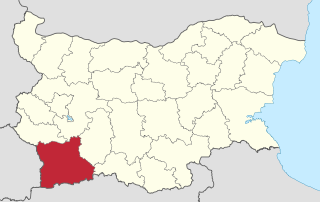
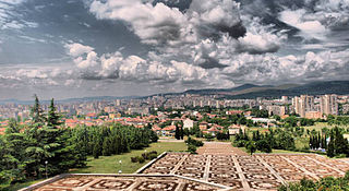
Blagoevgrad Province, also known as Pirin Macedonia or Bulgarian Macedonia, is a province (oblast) of southwestern Bulgaria. It borders four other Bulgarian provinces to the north and east, the Greek region of Macedonia to the south, and North Macedonia to the west. The province has 14 municipalities with 12 towns. Its principal city is Blagoevgrad, while other significant towns include Bansko, Gotse Delchev, Melnik, Petrich, Razlog, Sandanski, and Simitli.

Haskovo Province is a province in southern Bulgaria, neighbouring Greece and Turkey to the southeast, comprising parts of the Thracian valley along the river Maritsa. It is named after its administrative and industrial centre - the city of Haskovo. The province embraces a territory of 5,533.3 km2 (2,136.4 sq mi) that is divided into 11 municipalities with a total population, as of December 2009, of 256,408 inhabitants.

Gabrovo Province is a small province lying at the geographical centre of Bulgaria. It is named after its main town - Gabrovo. In 2009 the total population of the area is 130,001.

Montana Province is a province in northwestern Bulgaria, bordering Serbia in the southwest and Romania in the north. It spreads its area between the Danube river and the Balkan Mountains. As of February 2011, the province has a population of 148,098 inhabitants, on territory of 3,635.5 km2 (1,403.7 sq mi). It was named after its administrative centre the city of Montana.

Bansko is a town in southwestern Bulgaria, located at the foot of the Pirin Mountains at an elevation of 1200m above sea level. It is a ski resort.
Stara Zagora is the fifth-largest agglomeration in Bulgaria, and the administrative capital of the homonymous Stara Zagora Province located in the historical region of Thrace.
Radomir is a town in the Radomir Municipality in the Pernik Province of Bulgaria.
The Battle of Velbazhd is a battle which took place between Bulgarian and Serbian armies on 28 July 1330, near the town of Velbazhd.

Mezdra is a town in northwestern Bulgaria, part of Vratsa Province. It is located on the left bank of the Iskar River just north of its gorge through the Balkan Mountains.

Sredets is a town in Burgas Province in southeastern Bulgaria. It is located near Lake Mandrensko and the northern slopes of Strandzha. Sredets is the administrative centre of Sredets Municipality.
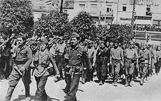
The 1944 Bulgarian coup d'état, also known as the 9 September coup d'état, was the forcible change of the government of Kingdom of Bulgaria carried out on the eve of 9 September 1944. In Communist Bulgaria it was called People's Uprising of 9 September – on the grounds of the broad unrest, and Socialist Revolution – as it was a turning point politically and the beginning of radical reforms towards socialism.

Tervel is a town in northeastern Bulgaria, part of Dobrich Province. It is the administrative centre of Tervel Municipality, which lies in the westernmost part of the province. As of December 2009, the town has a population of 6,667 inhabitants.
Loznitsa is a small town in northeastern Bulgaria, part of Razgrad Province, located in the geographic region of Ludogorie. It is the administrative centre of the homonymous Loznitsa Municipality, which lies in the southernmost part of the Province. As of December 2009, the town has a population of 2,409 inhabitants.

Strezimirovci is a divided village in easternmost Serbia and westernmost Bulgaria. The Bulgarian half of the village is part of Tran Municipality, Pernik Province, whereas the Serbian part belongs to Surdulica municipality, Pčinja District. The village has a border checkpoint and its residents on either side of the border are mostly Bulgarian; however, its division has caused its population to decrease more than tenfold. It lies in the geographic region of Znepolje (Znepolјe), at 42°48′N22°26′E, in a valley along the Jerma River, 830 metres above mean sea level.

Žeravino or Zheravino is a divided village in easternmost Serbia and westernmost Bulgaria. The Bulgarian half of the village is part of Kyustendil municipality, Kyustendil Province, whereas the Serbian part belongs to Bosilegrad municipality, Pčinja District.
