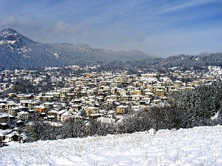
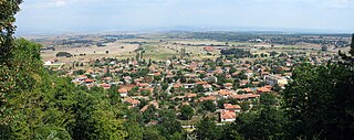
Smolyan is a town and ski resort in the south of Bulgaria near the border with Greece. It is the administrative and industrial centre of the Smolyan Province. The town is built along the narrow valley of the Cherna ('black') and the Byala ('white') river in the central Rhodope Mountains. It is located at the foot of the mountain's highest peak Golyam Perelik (2191 m). Popular ski resorts of Pamporovo and Chepelare lie in the vicinity. As of June 2022 the town has a population of 30 689 inhabitants.

Svilengrad is a town in Haskovo Province, south-central Bulgaria, situated at the tripoint of Bulgaria, Turkey, and Greece. It is the administrative centre of the homonymous Svilengrad Municipality.

Pythio, also referred to as Pythion (Πύθιον), is a village and community in the eastern part of Didymoteicho municipality, Evros regional unit, Greece. It is 16 km east of the centre of Didymoteicho, on the right bank of the river Evros, where it forms the border with Turkey. There is no road border crossing near Pythio
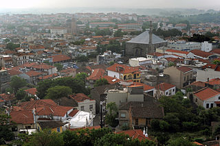
Didymoteicho is a town located on the eastern edge of the Evros regional unit of Eastern Macedonia and Thrace, in northeastern Greece. It is the seat of the municipality of the same name. The town sits on a plain and located south east of Svilengrad, south of Edirne, Turkey and Orestiada, west of Uzunköprü, Turkey, about 20 km north of Soufli and about 90 km north of Alexandroupoli. The municipality of Didymóteicho has a land area of 565.4 km2 and a population of 16,060 inhabitants.
Topolovgrad is a town in south-central Bulgaria, part of Haskovo Province, situated at the northern foot of the Sakar Mountain. It is the administrative centre of the homonymous Topolovgrad Municipality.
Trígono is a former municipality in the Evros regional unit, East Macedonia and Thrace, Greece. Since the 2011 local government reform, it is part of the municipality Orestiada, of which it is a municipal unit. The municipal unit has an area of 392.538 km2. The seat of the municipality was in Dikaia. The municipality was created in 1997 under the Capodistrian Plan. Trigono is the country's northernmost municipal unit, situated in the triangle between the rivers Evros and Ardas. It borders Bulgaria to the north and west, and Turkey to the northeast. The nearest cities are Svilengrad (Bulgaria) to the north, Edirne (Turkey) to the east, and Orestiada to the southeast. The area consists mainly of low hills, with plains in the river valleys, and higher elevations up to 400 m towards the west.

Tycheró is a town and a former municipality in the Evros regional unit, East Macedonia and Thrace, Greece. Since the 2011 local government reform it is part of the municipality Soufli, of which it is a municipal unit. The municipal unit has an area of 220.411 km2. Tychero is situated near the river Evros, which forms the border with Turkey here.
Chernichevo is a village in southern Bulgaria, located in the municipality of Krumovgrad in the Kardzhali Province. It is situated in the Eastern part of Rhodope Mountains, near the border with Greece. Its original Bulgarian name is "Dunyata". The correct geographical location of Chernichevo is 41° 21' N, 25° 47' E.

Sredets is a town in Burgas Province in southeastern Bulgaria. It is located near Lake Mandrensko and the northern slopes of Strandzha. Sredets is the administrative centre of Sredets Municipality.
General Toshevo is a town in northeastern Bulgaria, part of Dobrich Province. Located in the historic region of Southern Dobruja, it is the administrative centre of the homonymous municipality and was named after the noted Bulgarian General Stefan Toshev. As of December 2009, the town had a population of 7,130.
Komara is a village in the northwestern part of the Evros regional unit in northern Greece. Komara is in the municipal unit of Trigono. Komara is situated on the left (northern) bank of the river Arda, near the border with Bulgaria. It is 2 km north of Kyprinos, the nearest larger village. It is 20 km south of the Bulgarian town Svilengrad, 27 km northwest of Orestiada and 29 km west of the Turkish city Edirne.

Ormenio is the northernmost place in all of Greece. It is part of the municipal unit of Trigono in the Evros regional unit of Thrace. It is situated near the right bank of the river Evros, which forms the border with Bulgaria here. On the other side of the Evros, 6 km to the north, lies the Bulgarian town Svilengrad. Nearby villages in Greece are Ptelea to its southeast and Petrota to its southwest.

Brashlyan is a village in Malko Tarnovo Municipality, in Burgas Province, in southeastern Bulgaria. Known as Sarmashik until 1934, today the entire village is an architectural reserve displaying characteristic Strandzha wooden architecture from the mid-17th to the 19th century.
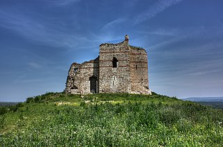
Mezek is a village in southeastern Bulgaria, part of Svilengrad municipality, Haskovo Province. It lies at the foot of the eastern Rhodope Mountains, just north of the Bulgaria–Greece border and not far west of the Bulgaria–Turkey border. Mezek is famous for the well-preserved medieval Mezek Fortress and its two ancient Thracian beehive tombs, the Mezek and Sheynovets tombs. The village is also well known for its own winery and the Mezzek brand of Bulgarian wine.
Matochina is a small village in southeastern Bulgaria, part of Svilengrad municipality, Haskovo Province. Matochina lies in the southernmost ridges of the Sakar Mountain, 40 kilometres (25 mi) from the municipal centre Svilengrad and 110 kilometres (68 mi) from the provincial capital Haskovo; it is located just west of the Bulgaria–Turkey border and not far northeast of the Bulgaria–Greece border. The village is famous for the medieval Matochina Fortress.
Dositeevo is a village in the municipality of Harmanli, in Haskovo Province, in southern Bulgaria. During the Ottoman rule of present-day Bulgaria, the name of the village was Suluköy. The village became part of the Principality of Bulgaria in 1885.
Shtit is a village in the municipality of Svilengrad, in Haskovo Province, in southern Bulgaria. Its current name dates to 1934; prior to that, it was known as Skutari.
Hlyabovo is a village in the municipality of Topolovgrad, in Haskovo Province, in southern Bulgaria.
Peplos is a town and a community of Feres municipal unit, Evros regional unit, East Macedonia and Thrace, Greece. Since the 2011 local government reform it is a part of the municipality Alexandroupoli. The town's population is around 1,000 people.

