
Dey, from the Turkish honorific title dayı, literally meaning uncle, was the title given to the rulers of the Regency of Algiers (Algeria), Tripoli, and Tunis under the Ottoman Empire from 1671 onwards. Twenty-nine deys held office from the establishment of the deylicate in Algeria until the French conquest in 1830.
Algeria, since December 18, 2019, is divided into 58 wilayas (provinces). Prior to December 18, 2019, there were 48 provinces. The 58 provinces are divided into 1,541 baladiyahs (municipalities). The name of a province is always that of its capital city.
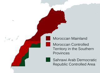
The Southern Provinces or Moroccan Sahara are the terms utilized by the Moroccan government to refer to the disputed territory of Western Sahara. These designations encompass the entirety of Western Sahara, which spans three of Morocco's 12 top-level administrative regions. The term "Southern Provinces" frequently appears in Moroccan state television.

Aurès is a natural region located in the mountainous area of the Aurès range in eastern Algeria. The region includes the Algerian provinces of Batna, Tebessa, Constantine, Khenchela, Oum El Bouaghi, Souk Ahras and Biskra. Some parts are located in Western Tunisia.

The People's National Assembly, abbreviated APN, is the lower house of the Algerian Parliament. It is composed of 407 members directly elected by the population. Of the 407 seats, 8 are reserved for Algerians living abroad. Members of the People's National Assembly are directly elected through proportional representation in multiple-member districts and serve terms lasting five years at a time. The last election for this body was held on 12 June 2021. The minimum age for election to the Assembly is 28.

Constantine is one of the 58 provinces (wilayas) of Algeria, whose capital is the city of the same name.
Bir Mourad Raïs, formerly Birmendreïs, is a town in Algiers Province, Algeria. The town is named in honor of the famous Ottoman admiral Murat Raïs. It is the birthplace of French Marxist philosopher Louis Althusser. As of 2008, its population was 45,345.

Tozeur is the westernmost of the 24 governorates (provinces) of Tunisia and as such bordering Algeria. It covers an area of 4,719 km2 and has a population of 107,912 making it the least populated province. The capital is Tozeur.
The Treaty of Tafna was signed by both Abd-el-Kader and General Thomas Robert Bugeaud on 30 May 1837. This agreement was developed after French imperial forces sustained heavy losses and military reversals in Algeria. The terms of the treaty entailed Abd-el-Kader recognizing French imperial sovereignty in Africa. However, the price France had to pay for acquiring recognition entailed its secession of approximately two thirds of Algeria to Abd-el-Kader. As a result of the treaty, France was able to maintain only a few ports.
ISO 3166-2:DZ is the entry for Algeria in ISO 3166-2, part of the ISO 3166 standard published by the International Organization for Standardization (ISO), which defines codes for the names of the principal subdivisions of all countries coded in ISO 3166-1.
The provinces of Algeria are divided into 547 districts. The capital of a district is called a district seat. Each District is further divided into one or more municipalities (baladiyahs).

The following outline is provided as an overview of and topical guide to Algeria:

Tadjenanet, formerly called Saint-Donat, is a town and commune in Mila Province, Algeria.

The Hautes Plaines, also known in French as Hauts Plateaux, is a steppe-like natural region located in the Atlas Mountains in northern Algeria. It stretches more than 600 km (370 mi) in an east northeast – west southwest direction from northeastern Morocco to the Aures. It is a high plateau area consisting of undulating, steppe-like alluvial plains lying between the Tell and Saharan Atlas ranges.

The Islamic State – Algeria Province is a branch of the militant Islamist group Islamic State (IS), active in Algeria. The group was formerly known as Jund al-Khilafah fi Ard al-Jazair.
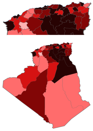
The COVID-19 pandemic in Algeria was a part of the worldwide pandemic of coronavirus disease 2019 caused by severe acute respiratory syndrome coronavirus 2. The virus was confirmed to have spread to Algeria in February 2020. In December it was announced that Algeria intended to launch COVID-19 vaccinations in January 2021.
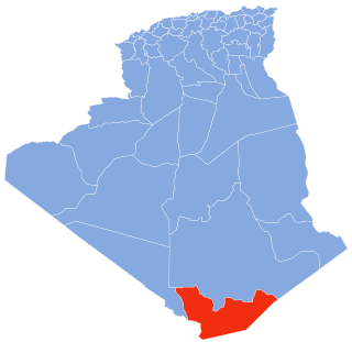
The Wilaya of In Guezzam is a newly created province in far southern Algeria that was created on December 18, 2019, after the Cabinet of Algeria passed a bill that created 10 new provinces in a rare move. Prior to that there was no creation of provinces in Algeria for 35 years. In Guezzam is the southernmost and least populous province of Algeria, as it lies along the border with Niger, and has a population of 11,202 in the present boundaries during the 2008 census. The capital of the province is also called In Guezzam as all Algerian provinces are required to be named after their capitals.
This page is based on this
Wikipedia article Text is available under the
CC BY-SA 4.0 license; additional terms may apply.
Images, videos and audio are available under their respective licenses.
