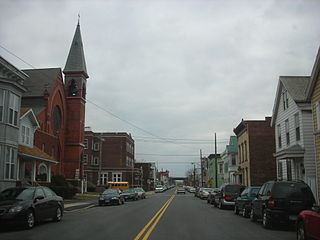
Rensselaer is a city in Rensselaer County, New York, United States, and is located on the east side of the Hudson River, opposite Albany and on the western border of Rensselaer County. As of the 2020 census, the city population was 9,210.

Schodack is a town in Rensselaer County, New York, United States. The population was 12,965 at the 2020 census. The town name is derived from the Mahican word, Escotak. The town is in the southwestern part of the county. Schodack is southeast of Albany, New York.
Green Island is a coterminous town-village in Albany County, New York, United States, some 8 miles (13 km) north of Albany. Green Island is one of only five such town-village amalgamations in New York. The population was 2,934 at the 2020 census, and the ZIP code is 12183. While the town of Green Island was once an island, it was connected to the mainland on the west side of the Hudson River in the 1960s.

East Greenbush is a town in Rensselaer County, New York, United States. It is a suburb of Albany. The population was 16,748 at the 2020 census. The word Greenbush is derived from the Dutch het groen bosch, referring to the pine woods that originally covered the land. The first settlement of the land now known as East Greenbush was made by tenants under patroon Kiliaen van Rensselaer circa 1630. The town was established in 1855 as Clinton, and was renamed in 1858. It is mostly suburban along its major highways and rural in the southwestern and northeastern corners.

Interstate 787 (I-787) is an auxiliary Interstate Highway in the US state of New York. I-787 is the main highway for those traveling into and out of downtown Albany. The southern terminus is, per New York traffic data, at New York State Thruway (I-87) exit 23 southwest of downtown Albany. However, current signage indicates the terminus as along I-787's ramp to US Route 9W (US 9W). The northern terminus of the route is unclear, with some sources placing the terminus at 8th Street in Troy, creating an overlap with New York State Route 7 (NY 7) between Green Island and Troy. Other documents show I-787 as terminating at its interchange with NY 7 and NY 787 in the town of Colonie. Regardless, the route is 10.16 miles (16.35 km) long if extended to Troy, or 9.55 miles (15.37 km) excluding the unsigned NY 7 overlap.

Rensselaerswyck was a Dutch colonial patroonship and later an English manor owned by the van Rensselaer family located in the present-day Capital District of New York in the United States.

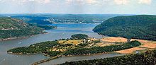
The Castleton Bridge is a cantilever truss bridge over the Hudson River, connecting Coeymans, Albany County with Schodack, Rensselaer County in New York. It carries the Berkshire Connector of the New York State Thruway. This bridge is also sometimes called the Castleton-on-Hudson Bridge and is situated in close proximity to the Alfred H. Smith Memorial Bridge, which is used by rail traffic.

New York State Route 470 (NY 470) is an east–west state highway in the Capital District of New York in the United States. It extends for 2.91 miles (4.68 km) from an intersection with NY 9R in the town of Colonie to a junction with U.S. Route 4 (US 4) in the city of Troy. Along the way, NY 470 intersects NY 787 in Cohoes and traverses the Hudson River via the 112th Street Bridge. NY 470 was assigned in February–March 1973 and is maintained by the cities of Cohoes and Troy.

New York State Route 9J (NY 9J) is a north–south state highway in the Hudson Valley region of New York in the United States. It begins at an intersection with US 9 in the Columbia County town of Stockport and extends for 22.35 miles (35.97 km) to an interchange with US 9 and US 20 in the Rensselaer County city of Rensselaer. The route parallels the Hudson River for its entire length, and several parts of the highway run directly alongside the river. NY 9J was assigned to its current alignment as part of the 1930 renumbering of state highways in New York.

New York State Route 787 (NY 787), known locally as Cohoes Boulevard, is a state highway in Albany County, New York, in the United States. It is a northern extension of Interstate 787 (I-787), continuing northward from the underpass at NY 7 near Green Island to downtown Cohoes at NY 32. For its entire length, NY 787 runs parallel to, and between, NY 32 and the Hudson River.

Interstate 90 (I-90) is a part of the Interstate Highway System that runs from Seattle, Washington, to Boston, Massachusetts. In the US state of New York, I-90 extends 385.48 miles (620.37 km) from the Pennsylvania state line at Ripley to the Massachusetts state line at Canaan, and is the second-longest highway in the state after New York State Route 17 (NY 17). Although most of the route is part of the tolled New York State Thruway, two non-tolled sections exist along I-90. Within New York, I-90 has a complete set of auxiliary Interstates, which means that there are Interstates numbered I-190 through I-990 in the state, with no gaps in between. For most of its length in New York, I-90 runs parallel to the former Erie Canal route, NY 5, US Route 20 (US 20) and the CSX Transportation railroad mainline that traverses the state.
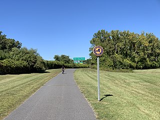
The Mohawk-Hudson Bike-Hike Trail (MHBHT) is a 97-mile (156 km) trail in New York's Mohawk Valley and Capital District regions. It is also the easternmost segment of the Erie Canalway Trail, as well as a portion of the Empire State Trail.
Castle Island is a former island located in the city of Albany, Albany County, New York. Over the past 400 years, Castle Island has been referred to as Martin Gerritse's Island, Patroon's Island, Van Rensselaer Island, and—since the late 19th century—Westerlo Island. The land known as Castle Island has been connected to the mainland and now forms a part of the Port of Albany.

The Port of Albany–Rensselaer, widely known as the Port of Albany, is a port of entry in the United States with facilities on both sides of the Hudson River in Albany and Rensselaer, New York. Private and public port facilities have existed in both cities since the 17th century, with an increase in shipping after the Albany Basin and Erie Canal were built with public funds in 1825.
Van Rensselaer Island was an island in the Hudson River opposite the city of Albany, New York. The island was also known as de Laet's Island, Kalebacker's Island, Boston Island and B&A Island, the last two names in reference to the Boston and Albany Railroad. The island stretched from Mill Creek north to the Livingston Avenue Bridge. Van Rensselaer Island is now connected to the City of Rensselaer, and is no longer an island.
The streets of Albany, New York have had a long history going back almost 400 years. Many of the streets have changed names over the course of time, some have changed names many times. Some streets no longer exist, others have changed course. Some roads existed only on paper. The oldest streets were haphazardly laid out with no overall plan until Simeon De Witt's 1794 street grid plan. The plan had two grids, one west of Eagle Street and the old stockade, and another for the Pastures District south of the old stockade.

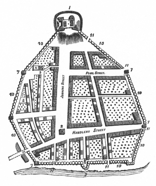
Van Schaick Island is an island in the city of Cohoes, New York. Van Schaick is a part of the delta of the Mohawk River at its mouth with the Hudson River. The island has been referred to by numerous names including Quehemesicos, Long, Anthony's, Isle of Cohoes, and Cohoes Island. The island was home to US Revolutionary War fortifications in the 18th century, and to an important shipyard in the 20th century. The shipyard and the extreme northern end of the island is part of the Peebles Island State Park, and the only vehicular entrance to the state park is on the island.
The history of Troy, New York extends back to the Mohican Indians. Troy is a city on the east bank of the Hudson River about 5 miles (8.0 km) north of Albany in the US State of New York.

North Albany is a neighborhood in the city of Albany, New York. North Albany was settled in the mid-17th century by the Patroon of Rensselaerswyck and his tenants and later became a hamlet in the town of Watervliet. Due to the Erie Canal being constructed in 1825, North Albany saw immense growth, with the Albany Lumber District and an influx of Irish immigrants lending the area the name of Limerick. Home to many historic warehouses and row houses, North Albany continues to be an important industrial neighborhood. Recent efforts have begun to gentrify the neighborhood by adapting heavy industry/warehouse use to artistic and entertainment venues, such as a German beer garden, an amusement park, live music venues, and arts and crafts marketplaces.

The Sprouts of the Mohawk River are the multiple channels of the Mohawk River as it flows into the Hudson River creating a delta in the US state of New York. Most of the sprouts lie within Albany County, with the northern ones in Saratoga County, and the sprouts enter the Hudson at the boundary with Rensselaer County. The islands formed by the sprouts are, from north to south–Peebles Island, Polrump Island, Bock Island, Goat Island, Second Island, Van Schaick Island, Simmons Island. and formerly Green Island. The sprout separating Green Island from the rest of Albany County was filled in with the creation of Interstate 787 and NY Route 787.