Areas


See also List of National Natural Landmarks in North Carolina
There are 13 National parks in North Carolina. Only the Great Smoky Mountains National Park is a traditional park. The Great Smoky Mountains National Park is also a World Heritage Site. Other parks include heritage areas, historic sites, national seashores, historic trails, and memorials managed by the National Park Service. Several of the parks include other states besides North Carolina. [1] [2]


See also List of National Natural Landmarks in North Carolina

Blount County is a county located in the East Tennessee Grand Division of the U.S. state of Tennessee. As of the 2020 census, its population was 135,280. The county seat is Maryville, which is also the county's largest city. Blount County is included in the Knoxville, Tennessee metropolitan statistical area.

Swain County is a county located on the far western border of the U.S. state of North Carolina. As of the 2020 census, the population was 14,117. Its county seat is Bryson City.

Bryson City is a town in and the county seat of Swain County, North Carolina, United States. The population was 1,558 as of the 2020 census. Located in what was historically the land of the Cherokee, Bryson City was founded as the Charleston to serve as the county seat of Swain County when it was formed from parts of surrounding counties. It grew into an important local rail hub. Today the city serves as a popular tourist destination, lying just to the west of the entrance to the Great Smoky Mountains National Park, for outdoor activities in the Nantahala National Forest, and along the Nantahala River and Fontana Lake, and serves as the home of the Great Smoky Mountains Railroad, a heritage railroad that provides tours of the Nantahala valley. The popular Nantahala Outdoor Center provides guide services for many of the outdoor activities in the area.

Townsend is a city in Blount County, Tennessee, in the southeastern United States. The city was chartered in 1921 by persons who were involved with the Little River Railroad and Lumber Company. The population was 244 at the 2000 census and 448 at the 2010 census. For thousands of years a site of Native American occupation by varying cultures, Townsend is one of three "gateways" to the Great Smoky Mountains National Park. It has several museums and attractions relating to the natural and human history of the Great Smokies.

Sevierville is a city in and the county seat of Sevier County, Tennessee, located in eastern Tennessee. The population was 17,889 at the 2020 United States Census.

The Blue Ridge Parkway is a National Parkway and All-American Road in the United States, noted for its scenic beauty. The parkway, which is America's longest linear park, runs for 469 miles (755 km) through 29 Virginia and North Carolina counties, linking Shenandoah National Park to Great Smoky Mountains National Park. It runs mostly along the spine of the Blue Ridge, a major mountain chain that is part of the Appalachian Mountains. Its southern terminus is at U.S. Route 441 (US 441) on the boundary between Great Smoky Mountains National Park and the Qualla Boundary of the Eastern Band of Cherokee Indians in North Carolina, from which it travels north to Shenandoah National Park in Virginia. The roadway continues through Shenandoah as Skyline Drive, a similar scenic road which is managed by a different National Park Service unit. Both Skyline Drive and the Virginia portion of the Blue Ridge Parkway are part of Virginia State Route 48 (SR 48), though this designation is not signed.

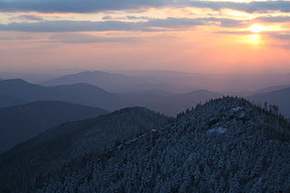
Great Smoky Mountains National Park is an American national park in the southeastern United States, with parts in North Carolina and Tennessee. The park straddles the ridgeline of the Great Smoky Mountains, part of the Blue Ridge Mountains, which are a division of the larger Appalachian Mountain chain. The park contains some of the highest mountains in eastern North America, including Clingmans Dome, Mount Guyot, and Mount Le Conte. The border between the two states runs northeast to southwest through the center of the park. The Appalachian Trail passes through the center of the park on its route from Georgia to Maine. With 14.1 million visitors in 2021, the Great Smoky Mountains National Park is the most visited national park in the United States.

The Blue Ridge Mountains are a physiographic province of the larger Appalachian Mountains range. The mountain range is located in the Eastern United States, and extends 550 miles southwest from southern Pennsylvania through Maryland, West Virginia, Virginia, North Carolina, South Carolina, Tennessee, and Georgia. This province consists of northern and southern physiographic regions, which divide near the Roanoke River gap. To the west of the Blue Ridge, between it and the bulk of the Appalachians, lies the Great Appalachian Valley, bordered on the west by the Ridge and Valley province of the Appalachian range.

The Great Smoky Mountains are a mountain range rising along the Tennessee–North Carolina border in the southeastern United States. They are a subrange of the Appalachian Mountains, and form part of the Blue Ridge Physiographic Province. The range is sometimes called the Smoky Mountains and the name is commonly shortened to the Smokies. The Great Smokies are best known as the home of the Great Smoky Mountains National Park, which protects most of the range. The park was established in 1934, and, with over 11 million visits per year, it is the most visited national park in the United States.

The Cherokee National Forest is a United States National Forest located in the U.S. states of Tennessee and North Carolina that was created on June 14, 1920. The forest is maintained and managed by the United States Forest Service. It encompasses an estimated area of 655,598 acres (2,653.11 km2).

Clingmans Dome is a mountain in the Great Smoky Mountains of Tennessee and North Carolina in the southeastern United States. Its name in Cherokee is Kuwahi or Kuwohi, meaning "mulberry place." At an elevation of 6,643 feet (2,025 m), it is the highest mountain in the Great Smoky Mountains National Park, the highest point in the state of Tennessee, and the highest point along the 2,192-mile (3,528 km) Appalachian Trail. It is also the third highest point in mainland Eastern North America, after Mount Mitchell and Mount Craig.
The Eastern Band of Cherokee Indians (EBCI), is a federally recognized Indian Tribe based in Western North Carolina in the United States. They are descended from the small group of 800–1000 Cherokee who remained in the Eastern United States after the US military, under the Indian Removal Act, moved the other 15,000 Cherokee to west of the Mississippi River in the late 1830s, to Indian Territory. Those Cherokee remaining in the East were to give up tribal Cherokee citizenship and to assimilate. They became US citizens.

Newfound Gap is a mountain pass located near the center of the Great Smoky Mountains National Park of the southern Appalachian Mountains in the United States of America. Situated along the border of Tennessee and North Carolina, the state line crosses the gap, as does Newfound Gap Road. The Appalachian Trail also traverses the gap, as do a small number of other hiking trails.

Western North Carolina is the region of North Carolina which includes the Appalachian Mountains; it is often known geographically as the state's Mountain Region. It contains the highest mountains in the Eastern United States, with 125 peaks rising to over 5,000 feet in elevation. Mount Mitchell at 6,684 feet, is the highest peak of the Appalachian Mountains and mainland eastern North America. The population of the region, as measured by the 2010 U.S. Census, is 1,473,241, which is approximately 15% of North Carolina's total population.

Shuckstack is a mountain in the Great Smoky Mountains of Swain County, North Carolina, in the southeastern United States. It has an elevation of 4,020 feet (1,230 m) above sea level, and rises approximately 2,300 feet (700 m) above Fontana Lake, to the south.

The Sugarlands is a valley in the north-central Great Smoky Mountains, located in the Southeastern United States. Formerly home to a string of small Appalachian communities, the valley is now the location of the Great Smoky Mountains National Park headquarters and the Sugarlands Visitor Center. Lying just south of Gatlinburg, the Sugarlands is one of the park's most popular access points.

Oconaluftee Archeological District is within the eponymous river valley in the Great Smoky Mountains of North Carolina, located in the Southeastern United States. Formerly a historic Cherokee village, followed by an Appalachian community, were located at this site along the Oconaluftee River. Now the site serves as the main entrance to the North Carolina side of the Great Smoky Mountains National Park.
This is a list of the National Register of Historic Places listings in Great Smoky Mountains National Park.
The Blue Ridge National Heritage Area is a federally designated National Heritage Area encompassing the twenty-five westernmost counties of North Carolina, which are associated with the Blue Ridge Mountains. The designation provides a framework for the promotion and interpretation of the area's cultural and historic character, and the preservation of the natural and built environment. The National Heritage Area includes the North Carolina portions of Great Smoky Mountains National Park and the Blue Ridge Parkway. Other attractions include Mount Mitchell in Pisgah National Forest, Nantahala National Forest and the North Carolina portion of the Appalachian Trail. The Qualla Boundary of the Eastern Band of Cherokee Indians is also within the National Heritage Area. The area's musical heritage and folk craftsmanship are also recognized by the National Heritage Area.

Too-Cowee, was an important historic Cherokee town located near the Little Tennessee River north of present-day Franklin, North Carolina. It also had a prehistoric platform mound and earlier village built by ancestral peoples. As their expression of public architecture, the Cherokee built a townhouse on top of the mound. It was the place for their community gatherings in their highly decentralized society. The name translates to "pig fat" in English. British traders and colonists referred to Cowee as one of the Cherokee Middle Towns along this river; they defined geographic groupings based in relation to their coastal settlements, such as Charlestown, South Carolina.