List of New Jersey Forest Fire Service fire towers

Last updated

The New Jersey Forest Fire Service erected the "Four Mile Tower", a simple tripod of wooden poles, in 1910. It was replaced by the Lebanon Station. New Jersey Forest Fire Service Four Mile Tower 1910.jpg
The New Jersey Forest Fire Service erected the "Four Mile Tower", a simple tripod of wooden poles, in 1910. It was replaced by the Lebanon Station.

In order to aid its efforts in wildland fire suppression and fire protection, the New Jersey Forest Fire Service operates a system of 21 fire towers at locations throughout the state of New Jersey in the United States. [2] From these fire towers, using an instrument called the Osborne Fire Finder, or an alidade, and topographical maps, trained fire observers are able to spot and triangulate the location of possible wildfires. After ascertaining the location, the observer will file a "smoke report" which will be investigated and appropriate action taken by a local firewarden. [2]

Contents

Founded in 1906, the New Jersey Forest Fire Service is the largest firefighting department within New Jersey and is an agency within the New Jersey Division of Parks and Forestry, a division of the New Jersey Department of Environmental Protection. With 85 full-time professional firefighters (career civil service positions), and approximately 2,000 trained part-time on-call wildland firefighters throughout the state, its mission is to protect "life and property, as well as the state's natural resources, from wildfire." [3] The agency covers a primary response area of 3,719,638 acres (1,505,284 ha) comprising 77% of the state's land area and administered by three regional divisions. This primary response area includes the state's rural and suburban areas, as well as its public state parks and forests. In 2014, the New Jersey Forest Fire Service responded to 1,063 wildfire events that destroyed 6,692 acres (2,708 ha). The service conducted controlled burns or prescribed burns on 15,326 acres (6,202 ha) statewide. [4]

The first fire lookout towers were often privately constructed during the late nineteenth century—many by large-tract landowners or corporations. However, after the creation of the Forest Fire Service, the state began erecting towers—some temporary, others permanent. The oldest erected by the Forest Fire Service that is in continuing operation is Culvers Station (then called the Normanook Fire Tower), first used in 1908, along the ridge of Kittatinny Mountain near Culver's Lake and the Culver's Gap. [lower-alpha 1] Many of the state's fire towers were built during the Great Depression by the Civilian Conservation Corps (CCC). More were erected during World War II, to aid both the Forest Fire Service and to the Aircraft Warning Service, operating from mid-1941 to mid-1944, in which fire observers were assigned additional duty as enemy aircraft spotters. During World War II, the Lakewood Station was "used to listen to German U-boat communications in the Atlantic Ocean 12 miles to the east". [6] Fire towers are located at key points of observation and on diverse terrain from northern New Jersey's mountain-and-valley terrain to the comparatively flat and low-elevation coastal plains in the south and central sections of the state. Today, these 21 towers provide New Jersey an inexpensive and effective first response system that aids the New Jersey Forest Fire Service in quickly suppressing and in preventing damage caused by reported wildfires. The Forest Fire Service estimates that 25 percent of wildfires within the state every year are first spotted by a lookout. [7]

A number of these fire towers are listed on the National Historic Lookout Register.

List of fire towers

Fire towers in active service

US#NJ#ImageTower NameElevationHeightNJFFS Division
Sections covered [8]
Location of towerCountyNotes
441 Culvers Lookout, Stokes State Forest, NJ.jpg Culvers Station
(previously Normanook Fire Tower)
1,509 feet (460 m)47 feet (14 m)Div. A
Sec. A1 (PA,NY)
Stokes State Forest,
Sandyston Township
41°11.270′N74°45.988′W / 41.187833°N 74.766467°W / 41.187833; -74.766467 (Culvers Station)
Sussex [9] [10]
452-Ramapo Station
(previously Wind-beam Lookout)
1,011 feet (308 m)50 feet (15 m)Div. A
Sec. A2 (A5&NY)
Ramapo Mountain State Forest
N41°03.521' W074°15.330'
Passaic [9] [11]
2446 Bearfort Fire Tower, West Milford, NJ.jpg Bearfort Station1,331 feet (406 m)68 feet (21 m)Div. A
Sec. A2, A5 (A1)
Bearfort Mountain
West Milford Township
41°06.254′N74°25.044′W / 41.104233°N 74.417400°W / 41.104233; -74.417400 (Bearfort Station)
Passaic [9] [12]
2468-Budd Lake Station
(previously 95 Mile Tree Lookout)
1,182 feet (360 m)60 feet (18 m)Div. A
Sec. A6,A3,(A4,A8,A7)
Mount Olive Township
N40°53.704' W074°45.026'
Morris [9] [13]
2479 2014-08-25 11 14 51 View southwest along the Appalachian Trail about 10.6 miles northeast of the Delaware Water Gap at Catfish Fire Tower in the Delaware Water Gap National Recreation Area, New Jersey.JPG Catfish Station1,555 feet (474 m)60 feet (18 m)Div. A
Sec. A3 (A6,PA)
Delaware Water Gap National Recreation Area
near Blairstown
N41°02.855' W074°58.347'
Warren [9] [14]
55312-Greystone Station909 feet (277 m)92 feet (28 m)Div. A
Sec. A7 A8,(A5,B10)
Union Hill, Denville
N40°51.341' W074°30.690'
Morris [9] [15]
56316-Milton Station1,341 feet (409 m)80 feet (24 m)Div. A
Sec. A4(A5)
Morris County Park
Jefferson Township
N41°00.520' W074°32.433'
Morris [9] [16]
2435 Bass River State Forest - fire lookout tower.jpg Bass River Station47 feet (14 m)80 feet (24 m)Div. B
Sec. B4,B2,C7
Bass River State Forest
39°36.694′N74°26.197′W / 39.611567°N 74.436617°W / 39.611567; -74.436617 (Bass River Station)
Burlington [6] [17]
56417 2014-08-29 11 34 32 The fire tower on top of Apple Pie Hill in Wharton State Forest, Tabernacle Township, New Jersey.JPG Apple Pie Hill Station179 feet (55 m)60 feet (18 m)Div. B
Sec. B1,B2,B3
Tabernacle Township
N39°48.443' W074°35.363'
Burlington [6] [18]
56518-Batsto Station70 feet (21 m)100 feet (30 m)Div. B
Sec. B2(B4,C8,C6)
Wharton State Forest
N39°38.976' W074°38.567'
Burlington [6] [19]
24810-Cedar Bridge Station204 feet (62 m)100 feet (30 m)Div. B
Sec. B7,B5,B4,B2
Lacey Township
N39°50.380' W074°22.836'
Ocean [6] [20]
55413-Jamesburg Station
(previously Old Bridge Fire Tower)
48 feet (15 m)60 feet (18 m)Div. B
Sec. B10,A7 (B9,A8)
Thompson County Park
Monroe Township
N40°20.233' W074°26.318'
Middlesex [6] [21]
55514-Lakewood Station136 feet (41 m)80 feet (24 m)Div. B
Sec. B7,B8,B9(B5,B6,B10)
Lakewood
N40°04.234' W074°13.674'
Ocean [6] [22]
55615-Lebanon Station136 feet (41 m)80 feet (24 m)Div. B
Sec. B3,B6,(B5,B2)
Brendan T. Byrne State Forest
N39°53.531' W074°34.880'
Burlington [1] [6]
56821-Medford Station141 feet (43 m)100 feet (30 m)Div. B
Sec. B1,B3(B2,C11)
Piper's Corner, Medford Township
N39°50.504' W074°47.375'
Burlington [6] [23]
2457-Belleplain Station56 feet (17 m)100 feet (30 m)Div. C
Sec. C2(C4,C5,C6)
Belleplain State Forest
near Woodbine
N39°17.036' W074°50.948'
Cape May [24] [25]
24911 McKeetown Fire Tower, McKee City, NJ.jpg McKeetown Station75 feet (23 m)100 feet (30 m)Div. C
Sec. C6,C7,(C4,C5)
Egg Harbor Township
N39°26.304' W074°37.039'
Atlantic [24] [26]
56619-Blue Anchor Station152 feet (46 m)86 feet (26 m)Div. C
Sec. C11,C6,C9
Winslow Township
N39°40.978' W074°53.348'
Camden [24] [27]
56720-Dias Creek Station13 feet (4.0 m)100 feet (30 m)Div. C
Sec. C1,C2
Middle Township
N39°06.271' W074°52.699'
Cape May [24] [28]
56922-Millville Station83 feet (25 m)100 feet (30 m)Div. C
Sec. C3,C10,(C9)
Millville
N39°23.939' W075°04.436'
Cumberland [24] [29]
57023-Mizpah Station106 feet (32 m)100 feet (30 m)Div. C
Sec. C4,C5,(C9)
Mizpah, Hamilton Township
N39°28.989' W074°50.851'
Atlantic [24] [30]

Fire towers not in service

US#NJ#ImageTower NameElevationHeightNJFFS Division
Sections covered
Location of towerCountyNotes
793 Batsto Mansion with Fire Tower.jpg Batsto Mansion House Station
(also known as Batsto Manor House Station)
72 feet (22 m)-Div. B Batsto Village State Historic Site
N39°38.604' W074°38.893'
Burlington [6] [31]
834Green Pond Mountain Lookout
(or Picatinny Arsenal Tower) [lower-alpha 2]
1,240 feet (380 m)-Div. A Picatinny Arsenal
Jefferson Township
N40°57.003' W074°34.132'
Morris [8] [33]

See also

Related Research Articles

<span class="mw-page-title-main">Controlled burn</span> Technique to reduce potential fuel for wildfire through managed burning

A controlled or prescribed (Rx) burn, which can include hazard reduction burning, backfire, swailing or a burn-off, is a fire set intentionally for purposes of forest management, fire suppression, farming, prairie restoration or greenhouse gas abatement. A controlled burn may also refer to the intentional burning of slash and fuels through burn piles. Fire is a natural part of both forest and grassland ecology and controlled fire can be a tool for foresters.

<span class="mw-page-title-main">Cape May Lighthouse</span> Lighthouse

The Cape May Lighthouse is a lighthouse located in the U.S. state of New Jersey at the tip of Cape May, in Lower Township's Cape May Point State Park. It was built in 1859 under the supervision of U.S. Army engineer William F. Raynolds, was automated in 1946, and continues operation to this day.

<span class="mw-page-title-main">Black Elk Peak</span> Highest point in South Dakota

Black Elk Peak is the highest natural point in the U.S. state of South Dakota and the Midwestern United States. It lies in the Black Elk Wilderness area, in southern Pennington County, in the Black Hills National Forest. The peak lies 3.7 mi (6.0 km) west-southwest of Mount Rushmore. At 7,244 feet (2,208 m), it is the highest summit in the United States east of the Rocky Mountains. Though part of the North American Cordillera, it is generally considered to be geologically separate from the Rocky Mountains.

<span class="mw-page-title-main">Fire lookout</span> Person responsible for spotting fires from a fire lookout tower

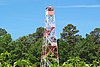
A fire lookout is a person assigned the duty to look for fire from atop a building known as a fire lookout tower. These towers are used in remote areas, normally on mountain tops with high elevation and a good view of the surrounding terrain, to spot smoke caused by a wildfire.

<span class="mw-page-title-main">Fire lookout tower</span> Building to house a person who watches for wildfires

A fire lookout tower, fire tower, or lookout tower is a tower that provides housing and protection for a person known as a "fire lookout", whose duty it is to search for wildfires in the wilderness. It is a small building, usually on the summit of a mountain or other high vantage point to maximize viewing distance and range, known as view shed. From this vantage point the fire lookout can see smoke that may develop, determine the location by using a device known as an Osborne Fire Finder, and call for wildfire suppression crews. Lookouts also report weather changes and plot the location of lightning strikes during storms. The location of the strike is monitored for a period of days afterwards, in case of ignition.

<span class="mw-page-title-main">Wildfire suppression</span> Firefighting tactics used to suppress wildfires

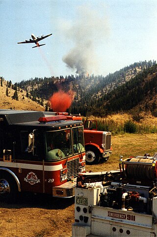
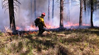
Wildfire suppression is a range of firefighting tactics used to suppress wildfires. Firefighting efforts depend on many factors such as the available fuel, the local atmospheric conditions, the features of the terrain, and the size of the wildfire. Because of this wildfire suppression in wild land areas usually requires different techniques, equipment, and training from the more familiar structure fire fighting found in populated areas. Working in conjunction with specially designed aerial firefighting aircraft, fire engines, tools, firefighting foams, fire retardants, and using various firefighting techniques, wildfire-trained crews work to suppress flames, construct fire lines, and extinguish flames and areas of heat in order to protect resources and natural wilderness. Wildfire suppression also addresses the issues of the wildland–urban interface, where populated areas border with wild land areas.

<span class="mw-page-title-main">New Jersey Division of Parks and Forestry</span> State agency of New Jersey, US

In the state of New Jersey, the New Jersey Division of Parks and Forestry is an administrative division of the New Jersey Department of Environmental Protection. In its most visible role, the Division is directly responsible for the management and operation of New Jersey's public park system which includes 42 state parks, 11 state forests, 3 recreation areas, and more than 50 historic sites and districts. However, its duties also include protecting state and private lands from wildfire, managing forests, educating the public about environmental stewardship and natural resources, as well as growing trees to maintain and restore forests in rural and urban areas, and to preserve the diversity of the trees within the forests.

<span class="mw-page-title-main">Watchman Lookout Station</span> United States historic place

The Watchman Lookout Station No. 168 is one of two fire lookout towers in Crater Lake National Park in southern Oregon. For many years, National Park Service personnel used the lookout to watch for wildfires during the summer months. It is also a common hiking destination because of its views of Crater Lake and the surrounding area. The building is unusual because it serves the dual purpose of fire lookout and museum. The Watchman Lookout Station is listed on the National Register of Historic Places.

<span class="mw-page-title-main">Azure Mountain</span> Mountain in New York, United States

Azure Mountain is a 2,323-foot-tall (708 m) mountain near Blue Mountain Road in the Adirondack Park town of Waverly in Franklin County, New York. Azure Mountain is the site of the Azure Mountain Fire Observation Station, a 35-foot-tall (11 m) steel tower that was built in 1918 and later restored in 2002. The fire tower was listed on the National Register of Historic Places in 2001.

<span class="mw-page-title-main">Azure Mountain Fire Observation Station</span> United States historic place

The Azure Mountain Fire Observation Station is a historic fire observation station located on Azure Mountain at Waverly in Franklin County, New York. The station and contributing resources include a 40-foot-tall (12 m), steel-frame lookout tower erected in 1918, a jeep trail now used as a hiking trail, which extends from the base of the mountain to two former observers' cabins, and a foot trail from the cabins to the summit. The tower is a prefabricated structure built by the Aermotor Corporation to provide a front line of defense in preserving the Adirondack Forest Preserve from the hazards of forest fires.

Wildfire suppression in the United States has had a long and varied history. For most of the 20th century, any form of wildland fire, whether it was naturally caused or otherwise, was quickly suppressed for fear of uncontrollable and destructive conflagrations such as the Peshtigo Fire in 1871 and the Great Fire of 1910. In the 1960s, policies governing wildfire suppression changed due to ecological studies that recognized fire as a natural process necessary for new growth. Today, policies advocating complete fire suppression have been exchanged for those who encourage wildland fire use, or the allowing of fire to act as a tool, such as the case with controlled burns.

<span class="mw-page-title-main">Arab Mountain Fire Observation Station</span> United States historic place

The Arab Mountain Fire Observation Station is a historic fire observation station located on Mount Arab at Piercefield in St. Lawrence County, New York. The station includes a 40-foot-tall (12 m), steel frame lookout tower erected in 1918, an observers cabin built about 1948, a trace of the foundation of the original cabin, a structure probably used as a root cellar in the 1940s, and the foot trail. The tower is a prefabricated structure built by the Aermotor Corporation and provided a front line of defense in preserving the Adirondack Forest Preserve from the hazards of forest fires.

<span class="mw-page-title-main">Aermotor Windmill Company</span> American Windmill Manufacturer

The Aermotor Windmill Company, or Aermotor Company, is an American manufacturer of wind-powered water pumps. The widespread use of their distinctive wind pumps on ranches throughout the arid plains and deserts of the United States has made their design a quintessential image of the American West.

<span class="mw-page-title-main">Pillsbury Mountain Forest Fire Observation Station</span> United States historic place

The Pillsbury Mountain Forest Fire Observation Station is a historic fire observation station located on Pillsbury Mountain summit at Arietta in Hamilton County, New York. The tower was built in 1924 by the Aermotor Windmill Company and the associated observer's cabin and shed in 1950. The lookout tower measures 69 feet tall.

<span class="mw-page-title-main">Margarita Lookout</span>

Margarita Lookout, also known as Santa Margarita Lookout, is a lookout point in the Santa Margarita Mountains, part of the larger Santa Ana Mountains in San Diego County, California. The original fire lookout tower, built in 1935 by the CCC, was later replaced by a new lookout tower and cabin in 1965. In 1986, the tower and cabin were both burned in a wildfire. In 1988, the burnt tower was destroyed in a collision with a Marine Corps CH-46E helicopter. The lookout tower was badly damaged as a result and was promptly removed. Only a concrete foundation remains today, however the site is still accessible via trail. The lookout is approximately one mile north of Margarita Peak, and is located in the Cleveland National Forest.

<span class="mw-page-title-main">Bearfort Mountain</span> Mountain ridge in West Milford, New Jersey

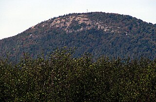
Bearfort Mountain, historically known as Bear Ford Mountain, is a mountain ridge located near Wawayanda State Park in West Milford, Passaic County, New Jersey. It is a continuation of Bellvale Mountain in New York. The Appalachian Trail crosses along the ridge into New York. Puddingstone of the Skunnemunk Conglomerate is visible along the ridge.

<span class="mw-page-title-main">New Jersey Forest Fire Service</span> New Jersey Department of Environmental Protection agency

The New Jersey Forest Fire Service (NJFFS) is an agency within the New Jersey Department of Environmental Protection. Founded in 1906 with a focus on wildland fire suppression and fire protection, the Forest Fire Service is the largest firefighting department within the state of New Jersey in the United States with 85 full-time professional firefighting personnel, and approximately 2,000 trained part-time on-call wildland firefighters throughout the state. Its mission is to protect "life and property, as well as the state's natural resources, from wildfire".

<span class="mw-page-title-main">Penn State Forest</span> State park in Burlington County, New Jersey

Penn State Forest is a 3,366-acre (5.259 sq mi) state park in Burlington County, New Jersey, United States. The forest is protected as a section of the environmentally sensitive Pine Barrens. Various recreational resources are available to visitors including Oswego Lake and the Oswego River for boating and fishing. The lake has a picnic area with a boat launch and primitive restrooms. Miles of unpaved roads composed of gravel, dirt, and sand traverse all areas of the forest. The roads are open for hiking, mountain biking, horseback riding, and cross-country skiing, as well as four-wheel driving. Hunting for deer, wild turkey, water fowl, and small game is permitted in season. A section of the Pine Barren Plains, a globally rare dwarf forest ecosystem that reaches a mature canopy height of about 4 ft (1.2 m), is located in the northeastern portion of the park. Penn State Forest is operated and maintained by the New Jersey Division of Parks and Forestry.

References

Notes

  1. Although the Forest Fire Service's lookout at Bearfort Station was built earlier (1884), it was built by the Newark Watershed Commission and operated by them until 1916. [5]
  2. According to Rieth, the Picatinny Arsenal Tower, which is located on a United States Army military research installation, is "not in service, but can be used". [8] NOTE: This fire tower is not the 215 feet (66 m) grey metal tower operated by Picatinny Arsenal Precision Armaments Laboratory that is visible from New Jersey Route 15 in Jefferson Township. [32]

Citations

  1. 1 2 National Historic Lookout Register, Lebanon Station Fire Tower US 556, NJ 15 Archived 2016-03-04 at the Wayback Machine . Retrieved 24 April 2015.
  2. 1 2 New Jersey Forest Fire Service, "Wildfire Suppression: Fire Towers". Retrieved 24 April 2015.
  3. New Jersey Forest Fire Service, "About Us". Retrieved 19 April 2015.
  4. State of New Jersey, Department of the Treasury, Office of Management and Budget, State of New Jersey Fiscal Year 2016 Detailed Budget, February 24, 2015, page D-113 to D-115.
  5. Forest Fire Lookout Association, "New Jersey Lookouts" (2006). Retrieved 25 April 2015.
  6. 1 2 3 4 5 6 7 8 9 10 New Jersey Forest Fire Service, "Wildfire Suppression: Division B Fire Towers". Retrieved 24 April 2015.
  7. Eric Sagara, "Eyes in the sky: How N.J.'s remaining fire towers spot blazes first", The Star-Ledger, 2 July 2012. Retrieved 30 April 2015.
  8. 1 2 3 John H. Rieth, "New Jersey Wildland Fire Agencies" at the Section B10, New Jersey Forest Fire Service website (2013). Retrieved 24 April 2015.
  9. 1 2 3 4 5 6 7 New Jersey Forest Fire Service, "Wildfire Suppression: Division A Fire Towers". Retrieved 24 April 2015.
  10. "Culvers Lookout US 44, NJ 1". National Historic Lookout Register. Archived from the original on 2016-03-04. Retrieved 2023-06-11..
  11. National Historic Lookout Register, Ramapo Station Fire Tower US 45, NJ 2 Archived 2016-03-04 at the Wayback Machine . Retrieved 24 April 2015.
  12. "Bearfort Fire Tower US 244, NJ 6". National Historic Lookout Register. Archived from the original on 2015-09-30. Retrieved 2023-06-10.
  13. National Historic Lookout Register, Budd Lake Fire Tower US 246, NJ 8 Archived 2015-07-05 at the Wayback Machine . Retrieved 24 April 2015.
  14. National Historic Lookout Register, Catfish Fire Tower US 247, NJ 9 Archived 2015-07-05 at the Wayback Machine . Retrieved 24 April 2015.
  15. National Historic Lookout Register, Greystone Station Fire Tower US 553, NJ 12 Archived 2016-03-04 at the Wayback Machine . Retrieved 24 April 2015.
  16. National Historic Lookout Register, Milton Station Fire Tower US 563, NJ 16 Archived 2015-04-24 at archive.today . Retrieved 24 April 2015.
  17. "Bass River Fire Tower US 243, NJ 5". National Historic Lookout Register. Archived from the original on 2015-10-02. Retrieved 2023-06-11..
  18. National Historic Lookout Register, Apple Pie Hill Station Fire Tower US 564, NJ 17 Archived 2016-03-04 at the Wayback Machine . Retrieved 24 April 2015.
  19. National Historic Lookout Register, Batsto Station Fire Tower US 565, NJ 18 Archived 2015-04-24 at archive.today . Retrieved 24 April 2015.
  20. National Historic Lookout Register, Cedar Bridge Fire Tower US 248, NJ 10 Archived 2015-07-06 at the Wayback Machine . Retrieved 24 April 2015.
  21. National Historic Lookout Register, Jamesburg Station Fire Tower US 554, NJ 13 Archived 2016-03-04 at the Wayback Machine . Retrieved 24 April 2015.
  22. National Historic Lookout Register, Lakewood Station Fire Tower US 555, NJ 14 Archived 2016-03-04 at the Wayback Machine . Retrieved 24 April 2015.
  23. National Historic Lookout Register, Medford Station Fire Tower US 568, NJ 21 Archived 2016-03-04 at the Wayback Machine . Retrieved 24 April 2015.
  24. 1 2 3 4 5 6 New Jersey Forest Fire Service, "Wildfire Suppression: Division C Fire Towers". Retrieved 24 April 2015.
  25. National Historic Lookout Register, Belleplain Fire Tower US 245, NJ 7 Archived 2015-10-02 at the Wayback Machine . Retrieved 24 April 2015.
  26. "McKeetown Fire Tower US 249, NJ 11". National Historic Lookout Register. Archived from the original on 2015-04-24. Retrieved 2023-06-10.
  27. National Historic Lookout Register, Blue Anchor Station Fire Tower US 566, NJ 19 Archived 2016-03-04 at the Wayback Machine . Retrieved 24 April 2015.
  28. National Historic Lookout Register, Dias Creek Station Fire Tower US 567, NJ 20 Archived 2016-03-04 at the Wayback Machine . Retrieved 24 April 2015.
  29. National Historic Lookout Register, Millville Station Fire Tower US 569, NJ 22 Archived 2016-03-04 at the Wayback Machine . Retrieved 24 April 2015.
  30. National Historic Lookout Register, Mizpah Station Fire Tower US 570, NJ 23 Archived 2016-03-04 at the Wayback Machine . Retrieved 24 April 2015.
  31. National Historic Lookout Register, Batsto Manor House Lookout US 79, NJ 3 Archived 2015-10-02 at the Wayback Machine . Retrieved 24 April 2015.
  32. United States Army, Picatinny Arsenal Precision Armaments Laboratory, Facilities/Capabilities: Tower. Retrieved 24 April 2015.
  33. National Historic Lookout Register, Green Pond Mountain Lookout US 83, NJ 4 Archived 2015-04-25 at archive.today . Retrieved 25 April 2015.