This article needs additional citations for verification .(July 2008) |
This page has a list of all the current stopping patterns on Transperth Trains services, in the Perth area, Western Australia. [1]
This article needs additional citations for verification .(July 2008) |
This page has a list of all the current stopping patterns on Transperth Trains services, in the Perth area, Western Australia. [1]
The Armadale line is a suburban rail service in Western Australia that runs from Perth to Armadale on the South Western Railway. This service is planned to extend to the suburb of Byford over an 8-kilometre-long (5.0 mi) new railway line constructed as part of the Byford Rail Extension project.

The Joondalup line is a commuter rail service in Western Australia, linking the Perth central business district (CBD) with the metropolitan area's north-western suburbs. The service is operated on the Northern Suburbs Railway by Transperth Train Operations, a division of the Public Transport Authority, and is part of the Transperth network. It is 40.7 kilometres (25.3 mi) long and serves 13 stations. The service is currently, as of 2022, being extended to Yanchep as part of the Yanchep Rail Extension project, and may be renamed once the extension to Yanchep is completed.

Perth railway station is the largest station on the Transperth network, serving the central business district of Perth, Western Australia. It serves as an interchange between the Armadale, Fremantle, Joondalup, Mandurah and Midland lines as well as Transwa's Australind service.

McIver railway station is a railway station on the Transperth network in Perth, Western Australia. It is located on the Armadale/Thornlie line and the Midland line, 0.9 kilometres from Perth station, providing access to Royal Perth Hospital.
Clarkson railway station is a commuter rail station in Clarkson, a suburb of Perth, Western Australia. It is on the Joondalup line, which is part of the Transperth network. Located in the median of the Mitchell Freeway, the station consists of an island platform connected to the west by a pedestrian footbridge. A six stand bus interchange and two carparks are located near the entrance.
SmartRider is the contactless electronic ticketing system of the Public Transport Authority of Western Australia. The system uses RFID smartcard technology to process public transport fares across public bus, train and ferry services.

Armadale Station is a railway station on the South Western Railway, 30 kilometres from Perth station serving the suburb of Armadale, Brookdale and Haynes. It is the terminating point for Transperth Armadale line services and a calling point for Transwa Australind services.
Cannington Station is a railway station serving the suburb of Cannington south of Perth, Western Australia. It is located 12.2 kilometres (7.6 mi) from Perth Station on the Armadale/Thornlie Line, part of the Transperth network.

Oats Street railway station is a railway station on the Transperth network in Perth, Western Australia. It is located on the Armadale and Thornlie line, 8.2 kilometres from Perth station serving the suburbs of Carlisle, East Victoria Park and Kewdale.

The Mandurah line is a commuter railway and service on the Transperth network in Western Australia that runs from Perth south to the state's second largest city Mandurah. The service is operated by Transperth Train Operations, a division of the Public Transport Authority. The line is 70.1 kilometres (43.6 mi) long and has 12 stations. At its northern end, the line begins as a continuation of the Joondalup line at Perth Underground, and ends as a continuation of the Joondalup line at Elizabeth Quay. The first 1.3 kilometres (0.81 mi) of the line is underground, passing under the Perth central business district. The line surfaces and enters the median of the Kwinana Freeway just north of the Swan River. It continues south down the freeway's median for 30 kilometres (19 mi), before veering south-west towards Rockingham. The final stretch of the line goes south from Rockingham to Mandurah.

Whitfords railway station is a railway station located on the boundary of Padbury and Kingsley, suburbs of Perth, Western Australia. It is on the Joondalup railway line, which is part of the Transperth commuter rail network. It is located in the median of the Mitchell Freeway, and consists of an elevated bus interchange on top of an island platform at ground level. South of Whitfords, trains run every 5 minutes during peak. North of Whitfords, trains run every 10 minutes during peak. Between peak during the day, trains run every 15 minutes. The journey to Perth railway station is 19.8 kilometres (12.3 mi), and takes 19 minutes.

The B-series trains are a class of electric multiple unit built by Downer Rail in Maryborough, Queensland for Transperth between 2004 and 2019.
New MetroRail was a division of the Public Transport Authority in Western Australia. It was responsible for managing extensions to Perth's railway network. The project doubled Perth's rail network, which is operated by Transperth, and was completed in 2007, after various projects were completed. Costing $1.6 billion, the project was the largest public transport project ever undertaken by the Western Australian government and effectively doubled the size of Perth's railway network. A similar agency Metronet was created in 2017 for future Perth rail extensions.

Transperth Train Operations is a division of the Public Transport Authority of Western Australia. It is responsible for operating Perth’s urban passenger rail system, as part of the Transperth network.
Transperth is the brand name of the public transport system serving the city and suburban areas of Perth, the state capital of Western Australia. It is managed by the Public Transport Authority (PTA), a state government organisation. Train operations are done by Transperth Train Operations, a division of the PTA. Bus operations are contracted out to Swan Transit, Path Transit and Transdev. Ferry operations are contracted out to Captain Cook Cruises.

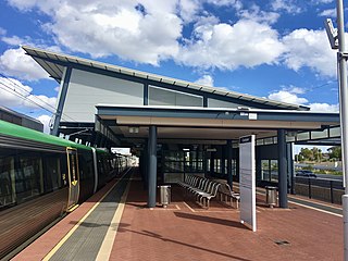
Perth Stadium railway station is a railway station in Burswood, Western Australia, next to Perth Stadium. With six platforms, the station is the second largest on the Transperth network, after Perth railway station.
Train reporting numbers are used on Australian railway networks to help network operators, and other users, coordinate train movements and identify trains. The numbers are used similarly to airline flight numbers, and enable a train to be identified to network controllers and other relevant authorities, and are also used by train operators for internal train management purposes.