National Places of Scenic Beauty
As of 1 July 2014, three Places have been designated at a national level; Sanbaseki Gorge spans the prefectural borders with Gunma and Landscape of Oku no Hosomichi is a serial designation spanning ten prefectures. [2] [3] [4]
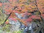
| Site | Municipality | Comments | Image | Coordinates | Type | Ref. |
|---|---|---|---|---|---|---|
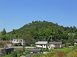
| Nagatoro Valley 長瀞 Nagatoro | Nagatoro/Minano | also a Natural Monument | 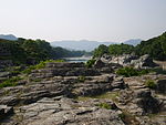 | 36°05′46″N139°06′54″E / 36.09618973°N 139.11491542°E | 6 | |
| Sanbaseki Gorge 三波石峡 Sanbasekkyō | Kamikawa | also a Natural Monument; designation includes an area of Fujioka in Gunma Prefecture |  | 36°07′46″N139°01′46″E / 36.12935391°N 139.02935467°E | 5, 6 | |
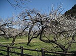
| Landscape of Oku no Hosomichi - Sōka-matsubara おくのほそ道の風景地 草加松原 Oku no Hosomichi no fūkei-chi Sōka-matsubara | Sōka | designation spans ten prefectures |  | 35°50′11″N139°48′27″E / 35.836342°N 139.807549°E | ||