National Places of Scenic Beauty
As of 27 January 2025, seven Places have been designated at a national level. [2] [3] [4]
| Site | Municipality | Comments | Image | Coordinates | Type | Ref. |
|---|---|---|---|---|---|---|
| Former Kurushima Family Gardens 旧久留島氏庭園 Kyū-Kurushima-shi teien | Kusu | 33°16′50″N131°09′12″E / 33.280530°N 131.153262°E | 1 | |||
| Hells of Beppu 別府の地獄 Beppu-no-jigoku | Beppu |  | 33°18′55″N131°28′27″E / 33.31530184°N 131.47412123°E | 9 | ||
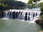
| Yabakei 耶馬渓 Yabakei | Hita, Usa, Nakatsu | within Yaba-Hita-Hikosan Quasi-National Park |  | 33°26′18″N131°14′19″E / 33.43834121°N 131.23874812°E | 5, 6 | |
| Tennen-ji Yaba - Mudō-ji Yaba 天念寺耶馬及び無動寺耶馬 Tennen-ji Yaba oyobi Mudō-ji Yaba | Bungotakada |  | 33°33′26″N131°26′41″E / 33.557220°N 131.444700°E | |||
| Nakayama Senkyō (Ebisu-dani) 中山仙境(夷谷) Nakayama-senkyō (Ebisu-dani) | Bungotakada |  | 33°36′55″N131°33′38″E / 33.615248°N 131.560603°E | |||
| Monju Yaba 文殊耶馬 Monju Yaba | Kunisaki |  | 33°36′09″N131°36′50″E / 33.602469°N 131.613875°E | |||
| Noike 納池 Noike | Taketa | 33°02′44″N131°17′57″E / 33.045467°N 131.299164°E | ||||