Related Research Articles

Chile, officially the Republic of Chile, is a country in the western part of South America. It occupies a long, narrow strip of land between the Andes to the east and the Pacific Ocean to the west. Chile covers an area of 756,096 square kilometers (291,930 sq mi), with a population of 17.5 million as of 2017. Chile is the southernmost country in the world, the closest to Antarctica, and share land borders with Peru to the north, Bolivia to the north-east, Argentina to the east, and the Drake Passage in the far south. Chile also controls the Pacific islands of Juan Fernández, Isla Salas y Gómez, Desventuradas, and Easter Island in Oceania. It also claims about 1,250,000 square kilometers (480,000 sq mi) of Antarctica under the Chilean Antarctic Territory. The country's capital and largest city is Santiago, and its national language is Spanish.

Tierra del Fuego is an archipelago off the southernmost tip of the South American mainland, across the Strait of Magellan. The archipelago consists of the main island, Isla Grande de Tierra del Fuego, with an area of 48,100 km2 (18,572 sq mi), and a group of many islands, including Cape Horn and Diego Ramírez Islands. Tierra del Fuego is divided between Chile and Argentina, with the latter controlling the eastern half of the main island and the former the western half plus the islands south of Beagle Channel and the southernmost islands. The southernmost extent of the archipelago is just north of latitude 56°S.

Easter Island is an island and special territory of Chile in the southeastern Pacific Ocean, at the southeasternmost point of the Polynesian Triangle in Oceania. The island is most famous for its nearly 1,000 extant monumental statues, called moai, which were created by the early Rapa Nui people. In 1995, UNESCO named Easter Island a World Heritage Site, with much of the island protected within Rapa Nui National Park.
The Valparaíso Region is one of Chile's 16 first order administrative divisions. With the country's second highest population of 1,790,219 in 2017, and fourth smallest area of 16,396.1 km2 (6,331 sq mi), the region is Chile's second most densely populated after the Santiago Metropolitan Region to the southeast. The region also includes the remote Easter Island in the Pacific Ocean.

The Desventuradas Islands is a group of four small islands located 850 kilometres (530 mi) off the coast of Chile, northwest of Santiago in the Pacific Ocean. They are considered part of Insular Chile.

Chiloé Island also known as Greater Island of Chiloé, is the largest island of the Chiloé Archipelago off the west coast of Chile, in the Pacific Ocean. The island is located in southern Chile, in the Los Lagos Region.

Elephant Island is an ice-covered, mountainous island off the coast of Antarctica in the outer reaches of the South Shetland Islands, in the Southern Ocean. The island is situated 245 kilometres north-northeast of the tip of the Antarctic Peninsula, 1,253 kilometres west-southwest of South Georgia, 935 kilometres south of the Falkland Islands, and 885 kilometres southeast of Cape Horn. It is within the Antarctic claims of Argentina, Chile and the United Kingdom.

Beagle Channel is a strait in the Tierra del Fuego Archipelago, on the extreme southern tip of South America between Chile and Argentina. The channel separates the larger main island of Isla Grande de Tierra del Fuego from various smaller islands including the islands of Picton, Lennox and Nueva; Navarino; Hoste; Londonderry; and Stewart. The channel's eastern area forms part of the border between Chile and Argentina and the western area is entirely within Chile.

Mataveri International Airport or Isla de Pascua Airport is at Hanga Roa on Rapa Nui /. The most remote airport in the world, it is 2,336 miles (3,759 km) from Santiago, Chile (SCL) which has scheduled flights to it on the Chilean carrier LATAM Chile. The runway starts just inland from the island's southeast coast at Mataveri, and nearly reaches the west coast, almost separating the mountain of Rano Kau from the rest of the island. The airport is the main point of entry for visitors to Easter Island. It has a transit lounge that was formerly used by passengers continuing to or returning from Papeete, Tahiti, which was serviced by LATAM until June 2020.

Discovery Bay is a bay 5 km (3 mi) long and 3 km (2 mi) wide, indenting the north side of Greenwich Island, in the South Shetland Islands of Antarctica. It had been known to sealers in the area since about 1821. It was charted and named in 1935 by Discovery Investigations personnel on the Discovery II.

The Chilean Antarctic Territory or Chilean Antarctica is the territory in Antarctica claimed by Chile. The Chilean Antarctic Territory ranges from 53° West to 90° West and from the South Pole to the 60° South parallel, partially overlapping the Argentine and British Antarctic claims. It is administered by the Cabo de Hornos municipality in the South American mainland.
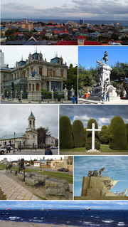
Punta Arenas is the capital city of Chile's southernmost region, Magallanes and Antarctica Chilena. The city was officially renamed as Magallanes in 1927, but in 1938 it was changed back to "Punta Arenas". It is the largest city south of the 46th parallel south, and at the same time the most populous southernmost city in Chile and in the Americas, and due to its location, the coldest coastal city with more than 100,000 inhabitants in Latin America. It is one of the most southerly ports in the world, serving as an Antarctic gateway city.

The Chiloé Archipelago is a group of islands lying off the coast of Chile, in the Los Lagos Region. It is separated from mainland Chile by the Chacao Channel in the north, the Sea of Chiloé in the east and the Gulf of Corcovado in the southeast. All islands except the Desertores Islands form Chiloé Province. The main island is Chiloé Island. Of roughly rectangular shape, the southwestern half of this island is a wilderness of contiguous forests, wetlands and, in some places, mountains. The landscape of the northeastern sectors of Chiloé Island and the islands to the east is dominated by rolling hills, with a mosaic of pastures, forests and cultivated fields.

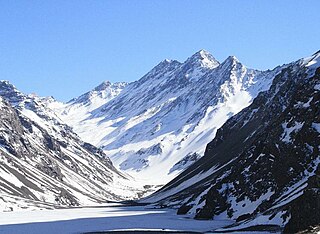
The geology of Chile is a characterized by processes linked to subduction such as volcanism, earthquakes and orogeny. The buildings blocks of Chile's geology assembled during the Paleozoic Era. Chile was by then the southwestern margin of the supercontinent Gondwana. In the Jurassic Gondwana began to split and the ongoing period of crustal deformation and mountain building known as the Andean orogeny began. In the Late Cenozoic Chile definitely separated from Antarctica, the Andes experienced a great rise accomplained by a cooling climate and the onset of glaciations.
Pendulum Cove is a cove at the north-east side of Port Foster, Deception Island, in the South Shetland Islands of Antarctica. The name of the cove derives from the pendulum and magnetic observations made there by the British expedition under Henry Foster in 1829.
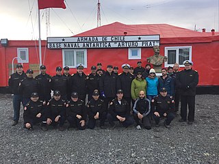
Captain Arturo Prat Base is a Chilean Antarctic research station located at Iquique Cove, Greenwich Island in the South Shetland Islands, Antarctica.
The following outline is provided as an overview of and topical guide to Chile:

Since the mid-1990s, tourism in Chile has become one of the main sources of income for the country, especially in its most extreme areas. In 2005, this sector grew by 13.6%, generating more than US$500 million, equivalent to 1.33% of the national GDP.

Barrientos Island is a small, ice-free island in the Aitcho group on the west side of English Strait in the South Shetland Islands, Antarctica. Extending 1.71 by 0.54 km, surface area 65 hectares. The area was visited by early 19th century sealers. Barrientos Island is a popular tourist site frequented by Antarctic cruise ships.
The prehispanic history of Chile refers to the period from the first human populations in the territory of Chile until the first European exploration of the region, by Spaniard Diego de Almagro in 1535-36.
References
- ↑ Pino, Mario; Chávez-Hoffmeister, Martín; Navarro-Harris, Ximena; Labarca, Rafael (2013), "The late Pleistocene Pilauco site, Osorno, south-central Chile", Quaternary International