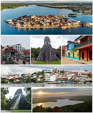
Petén is a department of Guatemala. It is geographically the northernmost department of Guatemala, as well as the largest by area – at 35,854 km2 (13,843 sq mi) it accounts for about one third of Guatemala's area. The capital is Flores. The population at the mid-2018 official estimate was 595,548.

Santa Rosa is a department in Guatemala. The capital is Cuilapa.
Huarijio is a Uto-Aztecan language of the states of Chihuahua and Sonora in northwestern Mexico. It is spoken by around 2,100 Huarijio people, most of whom are monolinguals.
Isthmus Nahuatl is a Nahuatl dialect cluster spoken by about 30,000 people in Veracruz, Mexico. According to Ethnologue 16, the Cosoleacaque dialect is 84% intelligible with Pajapan, and 83% intelligible with Mecayapan.

Almoloya de Juárez is a town in the State of Mexico and the seat of the municipality of Almoloya de Juárez. The name Almoloya comes from the Nahuatl, that is properly Almoloyan, composed of: atl, "water"; molo "impersonal voice of moloni, to flow the source" and yan, "place"; that it means "place where flows the water source".
Pima Bajo is a Mexican indigenous language of the Piman branch of the Uto-Aztecan language family, spoken by around 1,000 speakers in northern Mexico. The language is called O'ob No'ok by its speakers. The closest related languages are O'odham and the O'othams.

San Juan Bautista Tuxtepec, or simply referred to as Tuxtepec, is the head of the municipality by the same name and is the second most populous city of the Mexican state of Oaxaca. It is part of the Tuxtepec District of the Papaloapan Region. As of the 2020 census, the city is home to a population of 103,609 and 159,452 in the municipality, though census data are often under reported for various reasons.

Jerécuaro is a Mexican city located in the lowlands of the state of Guanajuato. The municipality has an area of 828.3 square kilometres and is bordered to the north by Apaseo el Alto, to the east by Coroneo and the state of Querétaro, to the south by Tarandacuao, to the southwest with Acámbaro, and to the northwest with Tarimoro. The municipality had 55,311 inhabitants according to the 2005 census. The municipal president of Jerécuaro and its many smaller outlying communities is C.Jaime García Cardona.
Tlatlaya is one of 125 municipalities of the State of Mexico in Mexico. The municipal seat is the town of Tlatlaya which is the eleventh largest town in the municipality. The word “Tlatlaya” means when the hearth is black and red.
San Jose Villa de Allende is a town and municipal seat of the municipality of Villa de Allende. It is the fifth largest town in the municipality. It is located 70 kilometers to the west of the city of Toluca. Villa de Allende was named in honor of Ignacio Allende, a hero of the Mexican War of Independence.
Otzoloapan Municipality is a municipality located at the southeast of the State of Mexico. The name is from the Náhuatl 'Oceloapan' which means "river of lynxes". It is located in the southwest part of the state bordering the state of Michoacán.
Tejupilco is a municipality in the State of Mexico, Mexico, located approximately 100 kilometres (62 mi) southwest of the state capital Toluca, along Federal Highway 134. Its municipal seat is Tejupilco de Hidalgo. The municipality has a total area of about 1,327 km2 (512 sq mi), with a contrasting topography ranging from deep ravines and canyons to high ridges; the highest elevation within the municipality reaches some 1,117 metres (3,660 ft) asl. The 2005 census recorded a population of 62,547 inhabitants.

Pinotepa Nacional is a city and seat of the municipality of the same name, in the Mexican state of Oaxaca. It is located in the Jamiltepec District in the west of the Costa Region. The name Pinotepa means "toward the crumbling hill" in Náhuatl.
Temascal is a town in the Mexican state of Oaxaca which is the seat of the municipality of San Miguel Soyaltepec. It is part of the Tuxtepec District of the Papaloapan Region. The name Soyaltepec means "hill of palm trees" in Náhuatl but the area also carries the Mazatec name of Naxhingee which means “ragged hill”.
Luvianos is a small town and municipality located in the southwest of the State of Mexico. It gained municipal status in 2000. People can access Luvianos by driving Federal Road 134 south from Toluca, and then take a detour about 25 minutes north of Tejupilco. The name is derived from a hacienda what was established during colonial times.

Santiago Papasquiaro is a municipality in the Mexican state of Durango. The municipal seat lies at Santiago Papasquiaro. The municipality covers an area of 7,238.4 km². Santiago Papasquiaro municipality is at an average height of 1,730 m (5,675 ft) over the sea level. The municipality lies east of Sierra Madre Occidental Mountain Range. It neighbors with other municipalities: Canelas and Tepehuanes municipalities at the north; San Dimas and Otáez, south; Nuevo Ideal to the east, Tamazula to the west and El Oro located northeast.

San Luis Acatlán is one of the 81 municipalities of Guerrero, in south-western Mexico. The municipal seat lies at San Luis Acatlán. The municipality covers an area of 704.4 km².

Apaxco is a municipality located in the Zumpango Region in Mexico. The municipal territory is located at a southern pass leading out of the Mezquital Valley about 288 km (179 mi) northeast of the state capital of Toluca. The name Apaxco comes from Nahuatl.
Under UNESCO’s Man and the Biosphere Programme, there are 125 biosphere reserves recognized as part of the World Network of Biosphere Reserves in Latin America and the Caribbean. These are distributed across 21 countries in the region.


